Property Record
1828 Cedar Ave, Bronx, NY 10453

Save to a Folder
{{folder.Name}}
{{folder.ListingIds.length}} Properties
{{folder.ListingIds.length}} Property
Create a New Folder
Property Detail
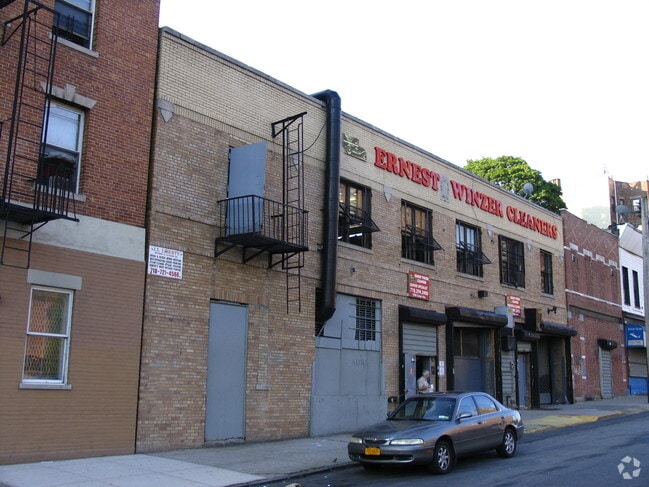
1828 Cedar Ave
02881-0012
Bronx
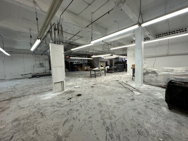
Lightindustrial
New York
R6
12
B and X Area of moderate flood hazard, usually the area between the limits of the 100-year and 500-year floods.
0.17 AC
2025
Bronx
2026
Westchester/So Connecticut
020502
New York-Jersey City-White Plains, NY-NJ
15,000 SF
NEARBY LISTINGS FOR SALE OR LEASE
-
-
-
-
-
-
-
-
-
-
-
-
-
-
No Photo
-
-
View all Bronx listings for sale on LoopNet.com
DEMOGRAPHICS near 1828 Cedar Ave
1 mile
3 mile
5 mile
2025 Total Population
250,015
1,239,333
2,140,706
2030 Population
252,078
1,244,843
2,143,291
Pop Growth 2025-2030
+ 0.83%
+ 0.44%
+ 0.12%
Average Age
39
39
40
2025 Total Households
87,306
448,855
792,672
HH Growth 2025-2030
+ 0.92%
+ 0.46%
+ 0.22%
Median Household Inc
$47,548
$47,256
$54,259
Avg Household Size
2.70
2.60
2.50
2025 Avg HH Vehicles
.00
.00
1.00
Median Home Value
$481,090
$481,560
$611,406
Median Year Built
1948
1949
1952
Nearby Places
Map Layers
Map Styles
 Street
 Aerial
Layers
 Traffic
 Biking
Places
Listings with unknown addresses are not visible on the map
- Restaurants
- Banks
- Shops
- Fitness
- Groceries
PUBLIC TRANSPORTATION
TRANSIT/SUBWAY
Morris Heights Station (Hudson Line - Metro-North Commuter Railroad Company (Metro-North))
Drive
Walk
Distance
Morris Heights Station (Hudson Line - Metro-North Commuter Railroad Company (Metro-North))
1 min
2 min
0.1 mi
176 Street (4 - New York MTA Subway (The Subway))
Drive
Walk
Distance
176 Street (4 - New York MTA Subway (The Subway))
3 min
13 min
0.7 mi
Mt Eden Avenue (4 - New York MTA Subway (The Subway))
Drive
Walk
Distance
Mt Eden Avenue (4 - New York MTA Subway (The Subway))
4 min
17 min
0.9 mi
COMMUTER RAIL
Morris Heights Station (Hudson Line - Metro-North Commuter Railroad Company (Metro-North))
Drive
Walk
Distance
Morris Heights Station (Hudson Line - Metro-North Commuter Railroad Company (Metro-North))
4 min
2 min
0.1 mi
University Heights Station (Hudson Line - Metro-North Commuter Railroad Company (Metro-North))
Drive
Walk
Distance
University Heights Station (Hudson Line - Metro-North Commuter Railroad Company (Metro-North))
3 min
18 min
0.9 mi
AIRPORT
LaGuardia
Drive
Walk
Distance
LaGuardia
19 min
9.6 mi
John F Kennedy International
Drive
Walk
Distance
John F Kennedy International
34 min
20.8 mi
Newark Liberty International
Drive
Walk
Distance
Newark Liberty International
29 min
22.3 mi
Freight Ports
NY - Red Hook Container Terminal
Drive
Walk
Distance
NY - Red Hook Container Terminal
32 min
17.7 mi
SALE & LEASE HISTORY
LISTING DATE
SALE/LEASE

Sep 27, 2023
For Sale
Apr 29, 2022
For Sale
Nearby Properties
Address
Land Use
TOTAL SIZE
Lot Size
Zoning
Address
Land Use
TOTAL SIZE
Lot Size
Zoning
1,290,000 SF
14.56 AC
PARK
Address
Land Use
TOTAL SIZE
Lot Size
Zoning
3,533,539 SF
8.37 AC
R8
Address
Land Use
TOTAL SIZE
Lot Size
Zoning
400,160 SF
10.96 AC
R7-2
Address
Land Use
TOTAL SIZE
Lot Size
Zoning
1,299,700 SF
29.82 AC
R6
Address
Land Use
TOTAL SIZE
Lot Size
Zoning
1,743,584 SF
77.87 AC
R6
Address
Land Use
TOTAL SIZE
Lot Size
Zoning
26.93 AC
R8
Address
Land Use
TOTAL SIZE
Lot Size
Zoning
2,278,432 SF
5.99 AC
R7-2
Address
Land Use
TOTAL SIZE
Lot Size
Zoning
24.08 AC
B2-A
Address
Land Use
TOTAL SIZE
Lot Size
Zoning
873,000 SF
9.95 AC
R7-2
Address
Land Use
TOTAL SIZE
Lot Size
Zoning
4.87 AC
R11
Address
Land Use
TOTAL SIZE
Lot Size
Zoning
1,651,267 SF
1.23 AC
R8
Address
Land Use
TOTAL SIZE
Lot Size
Zoning
Address
Land Use
TOTAL SIZE
Lot Size
Zoning
72 AC
P1
Address
Land Use
TOTAL SIZE
Lot Size
Zoning
2.61 AC
D5
Address
Land Use
TOTAL SIZE
Lot Size
Zoning
481,172 SF
205.58 AC
PARK
Address
Land Use
TOTAL SIZE
Lot Size
Zoning
895,256 SF
8.32 AC
R7-1
Address
Land Use
TOTAL SIZE
Lot Size
Zoning
891,040 SF
5.63 AC
R8
Address
Land Use
TOTAL SIZE
Lot Size
Zoning
1,311,800 SF
9.89 AC
C4-4
Address
Land Use
TOTAL SIZE
Lot Size
Zoning
1,237,424 SF
21.25 AC
R6
Address
Land Use
TOTAL SIZE
Lot Size
Zoning
204,200 SF
1.68 AC
R7-1
Address
Land Use
TOTAL SIZE
Lot Size
Zoning
42.68 AC
P1
Address
Land Use
TOTAL SIZE
Lot Size
Zoning
807,327 SF
0.60 AC
R8
Address
Land Use
TOTAL SIZE
Lot Size
Zoning
13.09 AC
C3
Address
Land Use
TOTAL SIZE
Lot Size
Zoning
2 AC
R11
Address
Land Use
TOTAL SIZE
Lot Size
Zoning
2,531,670 SF
17.15 AC
R7-2
Address
Land Use
TOTAL SIZE
Lot Size
Zoning
390,750 SF
265 AC
PARK
Address
Land Use
TOTAL SIZE
Lot Size
Zoning
598,815 SF
1.64 AC
R8
Address
Land Use
TOTAL SIZE
Lot Size
Zoning
39 AC
P1
Address
Land Use
TOTAL SIZE
Lot Size
Zoning
5.87 AC
R10
Address
Land Use
TOTAL SIZE
Lot Size
Zoning
2.55 AC
D5
The World's #1 Commercial Real Estate Marketplace
Connect with us
© 2026 CoStar Group
The information above has been obtained from sources believed reliable. While we do not doubt its accuracy we have not verified it and make no guarantee, warranty or representation about it. It is your responsibility to independently confirm its accuracy and completeness. Any projections, opinions, assumptions, or estimates used are for example only and do not represent the current or future performance of the property. The value of this transaction to you depends on tax and other factors which should be evaluated by your tax, financial, and legal advisors. You and your advisors should conduct a careful, independent investigation of the property to determine to your satisfaction the suitability of the property for your needs.