Property Record
18307 E Hampden Ave, Aurora, CO 80013
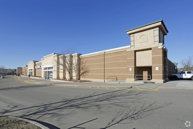

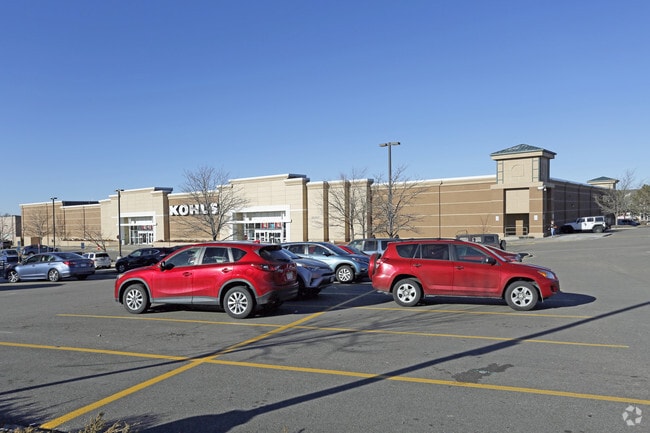
Property Detail
18307 E Hampden Ave
Denver-Aurora-Centennial, CO
SUBDIVISIONCD 035655 SUBDIVISIONNAME HUTCHINSON HEIGHTS SUB 25TH FLG BLOCK 001 LOT 002 LOT 2 BLK 1 HUTCHINSON HEIGHTS SUB 25TH FLG
1975-33-4-16-002
Arapahoe
Miscellaneous
Colorado
B and X Area of moderate flood hazard, usually the area between the limits of the 100-year and 500-year floods.
002
2024
8.55 AC
2025
Aurora
083300
Denver
89,225 SF
NEARBY LISTINGS FOR SALE OR LEASE
DEMOGRAPHICS near 18307 E Hampden Ave
1 mile
3 mile
5 mile
2024 Total Population
21,839
156,938
293,839
2029 Population
21,952
158,288
297,879
Pop Growth 2024-2029
+ 0.52%
+ 0.86%
+ 1.37%
Average Age
38
39
39
2024 Total Households
7,759
55,736
106,734
HH Growth 2024-2029
+ 0.62%
+ 0.93%
+ 1.45%
Median Household Inc
$96,870
$104,211
$99,222
Avg Household Size
2.70
2.70
2.70
2024 Avg HH Vehicles
2.00
2.00
2.00
Median Home Value
$478,886
$488,630
$513,040
Median Year Built
1984
1986
1987
Nearby Places
Map Layers
Map Styles
 Street
 Aerial
Transit
 Traffic
 Biking
Places
Listings with unknown addresses are not visible on the map
- Restaurants
- Banks
- Shops
- Fitness
- Groceries
PUBLIC TRANSPORTATION
COMMUTER RAIL
40Th Ave & Airport Blvd - Gateway Park Station Track 2 (Union Station to Denver Airport Station - Regional Transportation District)
Drive
Walk
Distance
40Th Ave & Airport Blvd - Gateway Park Station Track 2 (Union Station to Denver Airport Station - Regional Transportation District)
19 min
9.7 mi
AIRPORT
Denver International
Drive
Walk
Distance
Denver International
27 min
21.1 mi
Freight Ports
Tulsa Port Of Catoosa
Drive
Walk
Distance
Tulsa Port Of Catoosa
719 min
700.9 mi
Nearby Properties
Address
Land Use
TOTAL SIZE
Lot Size
Zoning
Address
Land Use
TOTAL SIZE
Lot Size
Zoning
525,600 SF
57.90 AC
Address
Land Use
TOTAL SIZE
Lot Size
Zoning
277,940 SF
31.61 AC
Address
Land Use
TOTAL SIZE
Lot Size
Zoning
328,000 SF
33.52 AC
PUD
Address
Land Use
TOTAL SIZE
Lot Size
Zoning
55,662 SF
3.71 AC
Address
Land Use
TOTAL SIZE
Lot Size
Zoning
142,378 SF
14.64 AC
Address
Land Use
TOTAL SIZE
Lot Size
Zoning
168,500 SF
24.03 AC
Address
Land Use
TOTAL SIZE
Lot Size
Zoning
368,462 SF
11.68 AC
RZMF
Address
Land Use
TOTAL SIZE
Lot Size
Zoning
462,048 SF
5.34 AC
RB3
Address
Land Use
TOTAL SIZE
Lot Size
Zoning
105,809 SF
48.79 AC
Address
Land Use
TOTAL SIZE
Lot Size
Zoning
376,563 SF
12.17 AC
AMU
Address
Land Use
TOTAL SIZE
Lot Size
Zoning
345,688 SF
15.15 AC
PUD
Address
Land Use
TOTAL SIZE
Lot Size
Zoning
135,050 SF
19.38 AC
Address
Land Use
TOTAL SIZE
Lot Size
Zoning
105,244 SF
12.64 AC
RPCZD
Address
Land Use
TOTAL SIZE
Lot Size
Zoning
26,880 SF
20.44 AC
Address
Land Use
TOTAL SIZE
Lot Size
Zoning
206,064 SF
25.38 AC
AMU
Address
Land Use
TOTAL SIZE
Lot Size
Zoning
172,715 SF
4.23 AC
Address
Land Use
TOTAL SIZE
Lot Size
Zoning
126,087 SF
13.17 AC
Address
Land Use
TOTAL SIZE
Lot Size
Zoning
96,480 SF
9.51 AC
PUD
Address
Land Use
TOTAL SIZE
Lot Size
Zoning
344,071 SF
17.10 AC
Address
Land Use
TOTAL SIZE
Lot Size
Zoning
307,372 SF
7.15 AC
Address
Land Use
TOTAL SIZE
Lot Size
Zoning
114,838 SF
12.50 AC
Address
Land Use
TOTAL SIZE
Lot Size
Zoning
303,614 SF
15.49 AC
RR2
Address
Land Use
TOTAL SIZE
Lot Size
Zoning
84,662 SF
8.14 AC
PUD
Address
Land Use
TOTAL SIZE
Lot Size
Zoning
299,289 SF
13.49 AC
Address
Land Use
TOTAL SIZE
Lot Size
Zoning
255,676 SF
13.97 AC
PUD
Address
Land Use
TOTAL SIZE
Lot Size
Zoning
262,202 SF
5.91 AC
Address
Land Use
TOTAL SIZE
Lot Size
Zoning
254,752 SF
14.71 AC
RZMF
Address
Land Use
TOTAL SIZE
Lot Size
Zoning
70,715 SF
13.57 AC
Address
Land Use
TOTAL SIZE
Lot Size
Zoning
44.65 AC
Address
Land Use
TOTAL SIZE
Lot Size
Zoning
36.34 AC
The World's #1 Commercial Real Estate Marketplace
Connect with us
© 2026 CoStar Group
The information above has been obtained from sources believed reliable. While we do not doubt its accuracy we have not verified it and make no guarantee, warranty or representation about it. It is your responsibility to independently confirm its accuracy and completeness. Any projections, opinions, assumptions, or estimates used are for example only and do not represent the current or future performance of the property. The value of this transaction to you depends on tax and other factors which should be evaluated by your tax, financial, and legal advisors. You and your advisors should conduct a careful, independent investigation of the property to determine to your satisfaction the suitability of the property for your needs.