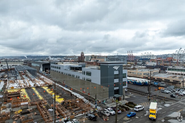
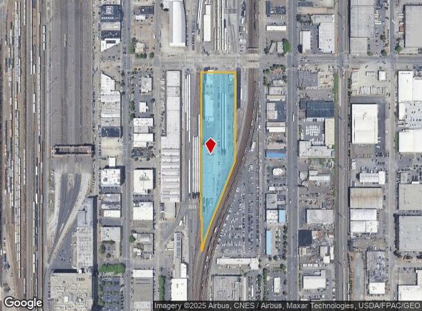
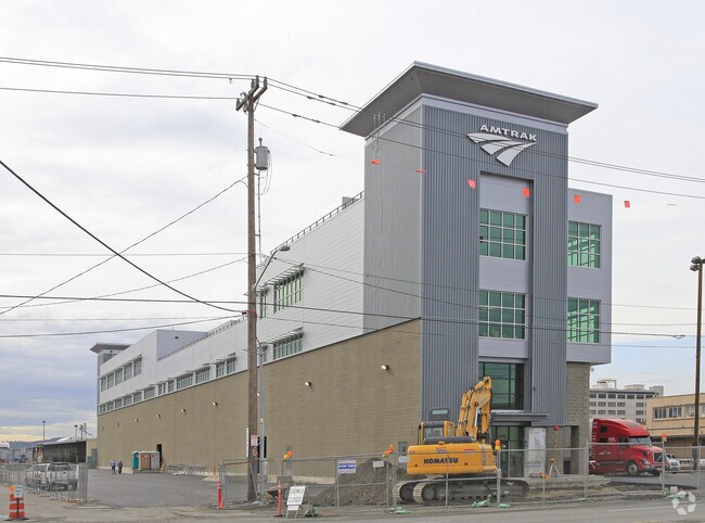
Property Record
185 S Holgate St, Seattle, WA 98134
NEARBY LISTINGS FOR SALE OR LEASE
Property Detail
185 S Holgate St
Seattle-Tacoma-Bellevue, WA
Seattle Tide Lds Bl 01-376
766620-5100
SEATTLE TIDE LANDS PARCEL B SEATTLE LOT BDRY ADJUSTMENT NO 2207829 REC NUMBER 20040527900005 BEING A POR OF BLOCKS 291-294- 316 AND 319 OF SEATTLE TIDE LANDS UNREC PLAT LY IN THE WEST 1/2 OF STR 08-24-04
Transportnec
King
X
Washington
53033C0630G
14
2021
6.04 AC
2024
SoDo
009300
Seattle/Puget Sound
63,420 SF
DEMOGRAPHICS near 185 S Holgate St
1 Mile
3 Mile
5 Mile
2024 Total Population
11,084
239,393
448,776
2029 Population
11,387
245,139
456,715
Pop Growth 2024-2029
+ 2.73%
+ 2.40%
+ 1.77%
Average Age
41
38
39
2024 Total Households
5,683
129,775
220,429
HH Growth 2024-2029
+ 2.60%
+ 2.44%
+ 1.85%
Median Household Inc
$78,088
$108,259
$112,951
Avg Household Size
1.80
1.70
1.90
2024 Avg HH Vehicles
1.00
1.00
1.00
Median Home Value
$717,292
$842,900
$880,560
Median Year Built
1983
1995
1984
Nearby Places
Map Layers
Map Styles
 Street
 Aerial
- Restaurants
- Banks
- Shops
- Fitness
- Groceries
PUBLIC TRANSPORTATION
TRANSIT/SUBWAY
St Light Rail & Sodo Station (Sb) (LINK to Sea-Tac - Sound Transit, Lynnwood - Angle Lake - Sound Transit)
DRIVE
WALK
Distance
St Light Rail & Sodo Station (Sb) (LINK to Sea-Tac - Sound Transit, Lynnwood - Angle Lake - Sound Transit)
2 min
13 min
0.7 mi
Stadium (Central Link - Central Puget Sound Regional Transit Authority Rail (Link Light Rail/Sounder))
DRIVE
WALK
Distance
Stadium (Central Link - Central Puget Sound Regional Transit Authority Rail (Link Light Rail/Sounder))
2 min
16 min
0.7 mi
Sodo (Central Link - Central Puget Sound Regional Transit Authority Rail (Link Light Rail/Sounder))
DRIVE
WALK
Distance
Sodo (Central Link - Central Puget Sound Regional Transit Authority Rail (Link Light Rail/Sounder))
3 min
13 min
0.7 mi
St Light Rail & Sodo Station (Nb) (LINK to Sea-Tac - Central Puget Sound Regional Transit Authority Rail (Link Light Rail/Sounder))
DRIVE
WALK
Distance
St Light Rail & Sodo Station (Nb) (LINK to Sea-Tac - Central Puget Sound Regional Transit Authority Rail (Link Light Rail/Sounder))
3 min
13 min
0.7 mi
St Light Rail & Stadium Station (Sb) (LINK to Sea-Tac - Sound Transit, Lynnwood - Angle Lake - Sound Transit)
DRIVE
WALK
Distance
St Light Rail & Stadium Station (Sb) (LINK to Sea-Tac - Sound Transit, Lynnwood - Angle Lake - Sound Transit)
2 min
15 min
0.7 mi
COMMUTER RAIL
King Street (Seattle) Station (Everett - Seattle - Sound Transit, Seattle - Tacoma/Lakewood - Sound Transit, Sounder South Line - Sound Transit)
DRIVE
WALK
Distance
King Street (Seattle) Station (Everett - Seattle - Sound Transit, Seattle - Tacoma/Lakewood - Sound Transit, Sounder South Line - Sound Transit)
3 min
1.1 mi
AIRPORT
Seattle-Tacoma International
DRIVE
WALK
Distance
Seattle-Tacoma International
23 min
13.9 mi
Seattle Paine Field International
DRIVE
WALK
Distance
Seattle Paine Field International
38 min
25.7 mi
Freight Ports
Port of Seattle
DRIVE
WALK
Distance
Port of Seattle
7 min
2.3 mi
Nearby Properties
Address
Land Use
TOTAL SIZE
Lot Size
Zoning
Address
Land Use
TOTAL SIZE
Lot Size
Zoning
800,000 SF
8.57 AC
SM-UP 95 (
Address
Land Use
TOTAL SIZE
Lot Size
Zoning
2.84 AC
DMC 340/29
Address
Land Use
TOTAL SIZE
Lot Size
Zoning
793,990 SF
30.81 AC
UI U/85
Address
Land Use
TOTAL SIZE
Lot Size
Zoning
946,212 SF
1.58 AC
DMC 340/29
Address
Land Use
TOTAL SIZE
Lot Size
Zoning
686,722 SF
1.26 AC
SM-SLU 240
Address
Land Use
TOTAL SIZE
Lot Size
Zoning
36,864 SF
8.02 AC
SM-UP 95 (
Address
Land Use
TOTAL SIZE
Lot Size
Zoning
992,925 SF
4.28 AC
MIO-240-HR
Address
Land Use
TOTAL SIZE
Lot Size
Zoning
1,526,621 SF
1.36 AC
DOC1 U/450
Address
Land Use
TOTAL SIZE
Lot Size
Zoning
716,128 SF
1.41 AC
SM-SLU 175
Address
Land Use
TOTAL SIZE
Lot Size
Zoning
1,062,251 SF
1.47 AC
DOC2 500/3
Address
Land Use
TOTAL SIZE
Lot Size
Zoning
763,898 SF
2.03 AC
DOC2 500/3
Address
Land Use
TOTAL SIZE
Lot Size
Zoning
1,137,666 SF
2.07 AC
DOC1 U/450
Address
Land Use
TOTAL SIZE
Lot Size
Zoning
7,930 SF
4.14 AC
MIO-240-HR
Address
Land Use
TOTAL SIZE
Lot Size
Zoning
6,379 SF
127.60 AC
MML U/85
Address
Land Use
TOTAL SIZE
Lot Size
Zoning
1,128,575 SF
1.30 AC
DOC1 U/450
Address
Land Use
TOTAL SIZE
Lot Size
Zoning
615,000 SF
0.88 AC
DOC2 500/3
Address
Land Use
TOTAL SIZE
Lot Size
Zoning
861,221 SF
1.30 AC
DMC 340/29
Address
Land Use
TOTAL SIZE
Lot Size
Zoning
377,813 SF
1.65 AC
DOC2 500/3
Address
Land Use
TOTAL SIZE
Lot Size
Zoning
1,011,547 SF
0.35 AC
DOC1 U/450
Address
Land Use
TOTAL SIZE
Lot Size
Zoning
1,478,612 SF
0.80 AC
DOC2 500/3
Address
Land Use
TOTAL SIZE
Lot Size
Zoning
67,235 SF
0.45 AC
DOC2 500/3
Address
Land Use
TOTAL SIZE
Lot Size
Zoning
922,344 SF
1.33 AC
DRC 85-170
Address
Land Use
TOTAL SIZE
Lot Size
Zoning
413,982 SF
0.58 AC
DMC 340/29
Address
Land Use
TOTAL SIZE
Lot Size
Zoning
412,000 SF
1.27 AC
DOC1 U/450
Address
Land Use
TOTAL SIZE
Lot Size
Zoning
943,610 SF
1.24 AC
DOC1 U/450
Address
Land Use
TOTAL SIZE
Lot Size
Zoning
155,795 SF
7.89 AC
SM-UP 95 (
Address
Land Use
TOTAL SIZE
Lot Size
Zoning
411,654 SF
0.59 AC
DMC 240/29
Address
Land Use
TOTAL SIZE
Lot Size
Zoning
436,497 SF
1.64 AC
SM-SLU 175
The World's #1 Commercial Real Estate Marketplace
Connect with us
© 2025 CoStar Group
The information above has been obtained from sources believed reliable. While we do not doubt its accuracy we have not verified it and make no guarantee, warranty or representation about it. It is your responsibility to independently confirm its accuracy and completeness. Any projections, opinions, assumptions, or estimates used are for example only and do not represent the current or future performance of the property. The value of this transaction to you depends on tax and other factors which should be evaluated by your tax, financial, and legal advisors. You and your advisors should conduct a careful, independent investigation of the property to determine to your satisfaction the suitability of the property for your needs.