Property Record
18680 E Iliff Ave, Aurora, CO 80013
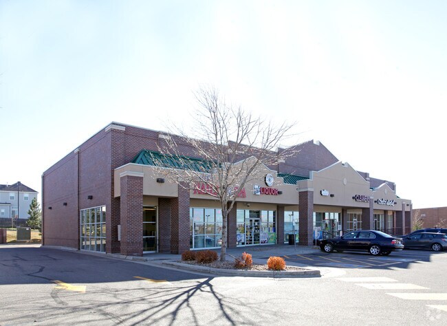

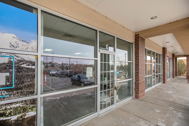
Property Detail
18680 E Iliff Ave
1975-27-2-31-001
SUBDIVISIONCD 055509 SUBDIVISIONNAME THE SHOPPES AT ILIFF SUB 1ST FLG BLOCK 001 LOT 001 LOT 1 BLK 1 THE SHOPPES AT ILIFF SUB 1ST FLG EX M/RS
Storebuilding
Arapahoe
RPCZD
Colorado
B and X Area of moderate flood hazard, usually the area between the limits of the 100-year and 500-year floods.
001
2024
1.54 AC
2025
Aurora
083100
Denver
8,378 SF
Denver-Aurora-Centennial, CO
NEARBY LISTINGS FOR SALE OR LEASE
DEMOGRAPHICS near 18680 E Iliff Ave
1 mile
3 mile
5 mile
2024 Total Population
21,969
133,143
308,491
2029 Population
22,184
134,766
313,255
Pop Growth 2024-2029
+ 0.98%
+ 1.22%
+ 1.54%
Average Age
38
38
38
2024 Total Households
7,859
47,946
111,649
HH Growth 2024-2029
+ 1.13%
+ 1.33%
+ 1.62%
Median Household Inc
$98,174
$92,039
$93,628
Avg Household Size
2.70
2.70
2.70
2024 Avg HH Vehicles
2.00
2.00
2.00
Median Home Value
$470,068
$460,135
$483,587
Median Year Built
1992
1985
1985
Nearby Places
Map Layers
Map Styles
 Street
 Aerial
Transit
 Traffic
 Biking
Places
Listings with unknown addresses are not visible on the map
- Restaurants
- Banks
- Shops
- Fitness
- Groceries
PUBLIC TRANSPORTATION
COMMUTER RAIL
Drive
Walk
Distance
17 min
8.3 mi
AIRPORT
Denver International
Drive
Walk
Distance
Denver International
24 min
19.4 mi
SALE & LEASE HISTORY
LISTING DATE
SALE/LEASE

Mar 31, 2020
For Lease
Jan 14, 2021
For Lease
Dec 23, 2022
For Lease
Nearby Properties
Address
Land Use
TOTAL SIZE
Lot Size
Zoning
Address
Land Use
TOTAL SIZE
Lot Size
Zoning
140,419 SF
8.37 AC
Address
Land Use
TOTAL SIZE
Lot Size
Zoning
201,600 SF
44.67 AC
R1
Address
Land Use
TOTAL SIZE
Lot Size
Zoning
277,940 SF
31.61 AC
Address
Land Use
TOTAL SIZE
Lot Size
Zoning
47,616 SF
140.42 AC
PUD
Address
Land Use
TOTAL SIZE
Lot Size
Zoning
43,568 SF
1.53 AC
Address
Land Use
TOTAL SIZE
Lot Size
Zoning
55,662 SF
3.71 AC
Address
Land Use
TOTAL SIZE
Lot Size
Zoning
142,378 SF
14.64 AC
Address
Land Use
TOTAL SIZE
Lot Size
Zoning
168,500 SF
24.03 AC
Address
Land Use
TOTAL SIZE
Lot Size
Zoning
186,088 SF
10.15 AC
RZIND
Address
Land Use
TOTAL SIZE
Lot Size
Zoning
368,462 SF
11.68 AC
RZMF
Address
Land Use
TOTAL SIZE
Lot Size
Zoning
364,024 SF
23.23 AC
PUD
Address
Land Use
TOTAL SIZE
Lot Size
Zoning
215,175 SF
28.07 AC
Address
Land Use
TOTAL SIZE
Lot Size
Zoning
462,048 SF
5.34 AC
RB3
Address
Land Use
TOTAL SIZE
Lot Size
Zoning
105,809 SF
48.79 AC
Address
Land Use
TOTAL SIZE
Lot Size
Zoning
345,688 SF
15.15 AC
PUD
Address
Land Use
TOTAL SIZE
Lot Size
Zoning
135,050 SF
19.38 AC
Address
Land Use
TOTAL SIZE
Lot Size
Zoning
105,244 SF
12.64 AC
RPCZD
Address
Land Use
TOTAL SIZE
Lot Size
Zoning
119,650 SF
10.60 AC
Address
Land Use
TOTAL SIZE
Lot Size
Zoning
126,087 SF
13.17 AC
Address
Land Use
TOTAL SIZE
Lot Size
Zoning
96,480 SF
9.51 AC
PUD
Address
Land Use
TOTAL SIZE
Lot Size
Zoning
325,111 SF
18.13 AC
PUD
Address
Land Use
TOTAL SIZE
Lot Size
Zoning
307,372 SF
7.15 AC
Address
Land Use
TOTAL SIZE
Lot Size
Zoning
114,838 SF
12.50 AC
Address
Land Use
TOTAL SIZE
Lot Size
Zoning
156,944 SF
27.45 AC
Address
Land Use
TOTAL SIZE
Lot Size
Zoning
146,784 SF
10.58 AC
Address
Land Use
TOTAL SIZE
Lot Size
Zoning
84,662 SF
8.14 AC
PUD
Address
Land Use
TOTAL SIZE
Lot Size
Zoning
299,289 SF
13.49 AC
Address
Land Use
TOTAL SIZE
Lot Size
Zoning
255,676 SF
13.97 AC
PUD
Address
Land Use
TOTAL SIZE
Lot Size
Zoning
104,233 SF
8.14 AC
The World's #1 Commercial Real Estate Marketplace
Connect with us
© 2026 CoStar Group
The information above has been obtained from sources believed reliable. While we do not doubt its accuracy we have not verified it and make no guarantee, warranty or representation about it. It is your responsibility to independently confirm its accuracy and completeness. Any projections, opinions, assumptions, or estimates used are for example only and do not represent the current or future performance of the property. The value of this transaction to you depends on tax and other factors which should be evaluated by your tax, financial, and legal advisors. You and your advisors should conduct a careful, independent investigation of the property to determine to your satisfaction the suitability of the property for your needs.