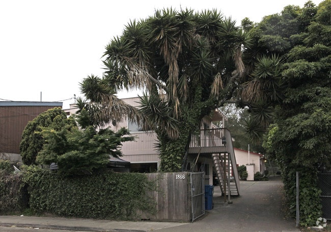
Property Record
1879 Woodland Ave, East Palo Alto, CA 94303


NEARBY LISTINGS FOR SALE OR LEASE
Property Detail
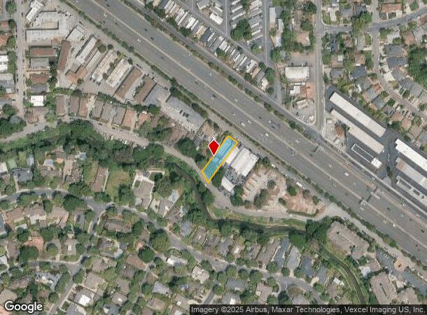
1879 Woodland Ave
San Francisco-Redwood City-South San Francisco, CA
Bayshore Freeway
063-501-040
ON SLY LINE OF BAYSHORE FREEWAY COM 452.96 FT WLY FR PULGAS AVE PTN LOT 15 FABER SUB RSM 8/31
Multifamilydwelling
San Mateo
A
California
06081C0309F
15
2024
0.24 AC
2025
East Palo Alto
612102
San Francisco
3,892 SF
DEMOGRAPHICS near 1879 Woodland Ave
1 Mile
3 Mile
5 Mile
2024 Total Population
22,645
122,851
242,446
2029 Population
21,621
118,222
234,497
Pop Growth 2024-2029
(4.52%)
(3.77%)
(3.28%)
Average Age
38
39
39
2024 Total Households
6,903
41,493
85,045
HH Growth 2024-2029
(4.65%)
(3.63%)
(3.19%)
Median Household Inc
$137,936
$152,103
$154,517
Avg Household Size
3.20
2.60
2.60
2024 Avg HH Vehicles
2.00
2.00
2.00
Median Home Value
$1,128,846
$1,133,545
$1,131,180
Median Year Built
1961
1963
1968
Nearby Places
Map Layers
Map Styles
 Street
 Aerial
- Restaurants
- Banks
- Shops
- Fitness
- Groceries
PUBLIC TRANSPORTATION
COMMUTER RAIL
California Avenue (Caltrain - Caltrain (Caltrain))
DRIVE
WALK
Distance
California Avenue (Caltrain - Caltrain (Caltrain))
7 min
2.5 mi
California Avenue Caltrain Station Southbound (Limited - Caltrain (Caltrain), Local Weekday - Caltrain (Caltrain), Local Weekend - Caltrain (Caltrain))
DRIVE
WALK
Distance
California Avenue Caltrain Station Southbound (Limited - Caltrain (Caltrain), Local Weekday - Caltrain (Caltrain), Local Weekend - Caltrain (Caltrain))
8 min
3.1 mi
AIRPORT
Norman Y Mineta San Jose International
DRIVE
WALK
Distance
Norman Y Mineta San Jose International
20 min
13.9 mi
San Francisco International
DRIVE
WALK
Distance
San Francisco International
27 min
19.9 mi
Metro Oakland International
DRIVE
WALK
Distance
Metro Oakland International
40 min
27.9 mi
Freight Ports
Port of Redwood City
DRIVE
WALK
Distance
Port of Redwood City
12 min
6.7 mi
Nearby Properties
Address
Land Use
TOTAL SIZE
Lot Size
Zoning
Address
Land Use
TOTAL SIZE
Lot Size
Zoning
719,052 SF
56.03 AC
Address
Land Use
TOTAL SIZE
Lot Size
Zoning
999,999 SF
56.91 AC
Address
Land Use
TOTAL SIZE
Lot Size
Zoning
1,395,540 SF
51.72 AC
C3
Address
Land Use
TOTAL SIZE
Lot Size
Zoning
22.07 AC
Address
Land Use
TOTAL SIZE
Lot Size
Zoning
Address
Land Use
TOTAL SIZE
Lot Size
Zoning
265,341 SF
13.53 AC
RP
Address
Land Use
TOTAL SIZE
Lot Size
Zoning
918,926 SF
17.54 AC
PC442
Address
Land Use
TOTAL SIZE
Lot Size
Zoning
4.13 AC
P39
Address
Land Use
TOTAL SIZE
Lot Size
Zoning
Address
Land Use
TOTAL SIZE
Lot Size
Zoning
210,000 SF
10.79 AC
Address
Land Use
TOTAL SIZE
Lot Size
Zoning
212,924 SF
1.83 AC
Address
Land Use
TOTAL SIZE
Lot Size
Zoning
164,853 SF
3.89 AC
Address
Land Use
TOTAL SIZE
Lot Size
Zoning
145,617 SF
8.24 AC
EA00C1
Address
Land Use
TOTAL SIZE
Lot Size
Zoning
652,964 SF
14.99 AC
GM
Address
Land Use
TOTAL SIZE
Lot Size
Zoning
516,963 SF
36.46 AC
RP
Address
Land Use
TOTAL SIZE
Lot Size
Zoning
190,389 SF
11.20 AC
M20000
Address
Land Use
TOTAL SIZE
Lot Size
Zoning
143,429 SF
2.12 AC
Address
Land Use
TOTAL SIZE
Lot Size
Zoning
149,700 SF
2.28 AC
Address
Land Use
TOTAL SIZE
Lot Size
Zoning
113,964 SF
6.28 AC
RP
Address
Land Use
TOTAL SIZE
Lot Size
Zoning
222,234 SF
6.39 AC
Address
Land Use
TOTAL SIZE
Lot Size
Zoning
184,142 SF
10.29 AC
RP
Address
Land Use
TOTAL SIZE
Lot Size
Zoning
190,000 SF
3.37 AC
Address
Land Use
TOTAL SIZE
Lot Size
Zoning
129,678 SF
7.17 AC
LMS
Address
Land Use
TOTAL SIZE
Lot Size
Zoning
128,051 SF
4.26 AC
P39
Address
Land Use
TOTAL SIZE
Lot Size
Zoning
161,432 SF
13.72 AC
RP
Address
Land Use
TOTAL SIZE
Lot Size
Zoning
224,852 SF
9.86 AC
GMB
Address
Land Use
TOTAL SIZE
Lot Size
Zoning
97,203 SF
5.91 AC
RP
Address
Land Use
TOTAL SIZE
Lot Size
Zoning
259,586 SF
17.92 AC
LMD
Address
Land Use
TOTAL SIZE
Lot Size
Zoning
102,690 SF
6.71 AC
Address
Land Use
TOTAL SIZE
Lot Size
Zoning
216,472 SF
8.73 AC
GM
The World's #1 Commercial Real Estate Marketplace
Connect with us
© 2025 CoStar Group
The information above has been obtained from sources believed reliable. While we do not doubt its accuracy we have not verified it and make no guarantee, warranty or representation about it. It is your responsibility to independently confirm its accuracy and completeness. Any projections, opinions, assumptions, or estimates used are for example only and do not represent the current or future performance of the property. The value of this transaction to you depends on tax and other factors which should be evaluated by your tax, financial, and legal advisors. You and your advisors should conduct a careful, independent investigation of the property to determine to your satisfaction the suitability of the property for your needs.