Property Record
1880 57Th Ct S, Boulder, CO 80301
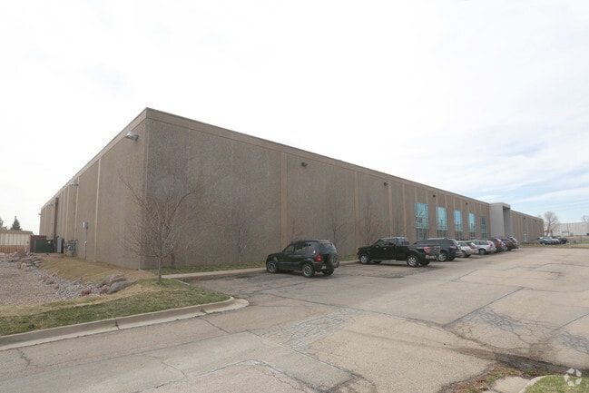


Property Detail
1880 57Th Ct S
Boulder, CO
LOTS 3 & 4 BLK 1 FLATIRONS INDUSTRIAL PARK
1463270-03-008
Boulder
Industrialgeneral
Colorado
AE The base floodplain where base flood elevations are provided. AE Zones are now used on new format FIRMs instead of A1-A30 Zones.
3
2024
4.20 AC
2025
Boulder
012707
Denver
80,000 SF
NEARBY LISTINGS FOR SALE OR LEASE
DEMOGRAPHICS near 1880 57Th Ct S
1 mile
3 mile
5 mile
2025 Total Population
3,907
75,161
138,892
2030 Population
3,953
75,197
138,381
Pop Growth 2025-2030
+ 1.18%
+ 0.05%
(0.37%)
Average Age
43
36
38
2025 Total Households
1,588
30,075
56,166
HH Growth 2025-2030
+ 1.20%
+ 0.13%
(0.36%)
Median Household Inc
$125,583
$68,418
$90,728
Avg Household Size
2.30
2.00
2.20
2025 Avg HH Vehicles
2.00
2.00
2.00
Median Home Value
$1,054,733
$871,256
$967,535
Median Year Built
1983
1980
1979
Nearby Places
Map Layers
Map Styles
 Street
 Aerial
Transit
 Traffic
 Biking
Places
Listings with unknown addresses are not visible on the map
- Restaurants
- Banks
- Shops
- Fitness
- Groceries
PUBLIC TRANSPORTATION
AIRPORT
Denver International
Drive
Walk
Distance
Denver International
53 min
43.2 mi
Nearby Properties
Address
Land Use
TOTAL SIZE
Lot Size
Zoning
Address
Land Use
TOTAL SIZE
Lot Size
Zoning
1,285,025 SF
17.46 AC
Address
Land Use
TOTAL SIZE
Lot Size
Zoning
30.08 AC
Address
Land Use
TOTAL SIZE
Lot Size
Zoning
14.66 AC
Address
Land Use
TOTAL SIZE
Lot Size
Zoning
171.91 AC
Address
Land Use
TOTAL SIZE
Lot Size
Zoning
1,892,750 SF
200 AC
Address
Land Use
TOTAL SIZE
Lot Size
Zoning
941,000 SF
44 SF
Address
Land Use
TOTAL SIZE
Lot Size
Zoning
329,080 SF
16.41 AC
Address
Land Use
TOTAL SIZE
Lot Size
Zoning
244,999 SF
2.24 AC
Address
Land Use
TOTAL SIZE
Lot Size
Zoning
599,605 SF
4.46 AC
Address
Land Use
TOTAL SIZE
Lot Size
Zoning
842,665 SF
59.42 AC
Address
Land Use
TOTAL SIZE
Lot Size
Zoning
520,605 SF
42.57 AC
C
Address
Land Use
TOTAL SIZE
Lot Size
Zoning
385,761 SF
19.07 AC
Address
Land Use
TOTAL SIZE
Lot Size
Zoning
161,616 SF
8 AC
Address
Land Use
TOTAL SIZE
Lot Size
Zoning
186.43 AC
RR
Address
Land Use
TOTAL SIZE
Lot Size
Zoning
518,974 SF
65.71 AC
Address
Land Use
TOTAL SIZE
Lot Size
Zoning
25.41 AC
GI
Address
Land Use
TOTAL SIZE
Lot Size
Zoning
38.79 AC
RR
Address
Land Use
TOTAL SIZE
Lot Size
Zoning
48.98 AC
A
Address
Land Use
TOTAL SIZE
Lot Size
Zoning
117,540 SF
Address
Land Use
TOTAL SIZE
Lot Size
Zoning
69.99 AC
ER
Address
Land Use
TOTAL SIZE
Lot Size
Zoning
161,761 SF
4.79 AC
Address
Land Use
TOTAL SIZE
Lot Size
Zoning
276,166 SF
2.98 AC
Address
Land Use
TOTAL SIZE
Lot Size
Zoning
173,205 SF
3.35 AC
Address
Land Use
TOTAL SIZE
Lot Size
Zoning
161,711 SF
20.40 AC
MH
Address
Land Use
TOTAL SIZE
Lot Size
Zoning
159,270 SF
9.52 AC
Address
Land Use
TOTAL SIZE
Lot Size
Zoning
107.31 AC
A
Address
Land Use
TOTAL SIZE
Lot Size
Zoning
27.92 AC
RR
Address
Land Use
TOTAL SIZE
Lot Size
Zoning
29.20 AC
RR
Address
Land Use
TOTAL SIZE
Lot Size
Zoning
234,050 SF
30.93 AC
Address
Land Use
TOTAL SIZE
Lot Size
Zoning
1,008 SF
16.27 AC
The World's #1 Commercial Real Estate Marketplace
Connect with us
© 2026 CoStar Group
The information above has been obtained from sources believed reliable. While we do not doubt its accuracy we have not verified it and make no guarantee, warranty or representation about it. It is your responsibility to independently confirm its accuracy and completeness. Any projections, opinions, assumptions, or estimates used are for example only and do not represent the current or future performance of the property. The value of this transaction to you depends on tax and other factors which should be evaluated by your tax, financial, and legal advisors. You and your advisors should conduct a careful, independent investigation of the property to determine to your satisfaction the suitability of the property for your needs.