Property Record
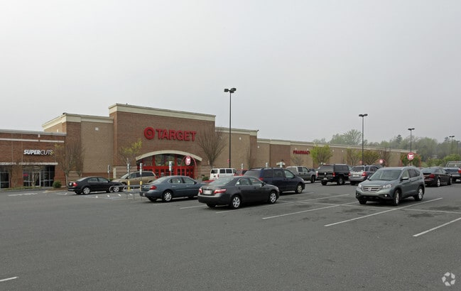
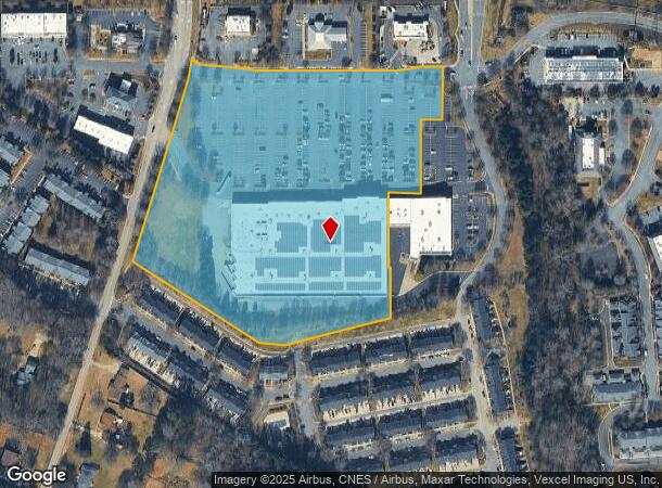
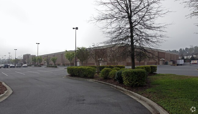
1884 Springsteen Rd, Rock Hill, SC 29730
NEARBY LISTINGS FOR SALE OR LEASE
Property Detail
1884 Springsteen Rd
6670101076
Wds
Commercialnec
TARGET OFF DAVE LYLE 12.84 AC LANDSCAPE MAINTENANCE DISTRICT
X
York
45091C0328F
South Carolina
2025
11.33 AC
2025
York County
060300
Charlotte
129,679 SF
Charlotte-Concord-Gastonia, NC-SC
DEMOGRAPHICS near 1884 Springsteen Rd
1 Mile
3 Mile
5 Mile
2024 Total Population
5,682
40,486
99,987
2029 Population
6,405
45,414
112,563
Pop Growth 2024-2029
+ 12.72%
+ 12.17%
+ 12.58%
Average Age
37
37
38
2024 Total Households
2,525
16,340
39,496
HH Growth 2024-2029
+ 13.07%
+ 13.02%
+ 13.13%
Median Household Inc
$53,795
$51,401
$58,764
Avg Household Size
2.20
2.30
2.40
2024 Avg HH Vehicles
2.00
2.00
2.00
Median Home Value
$219,788
$198,873
$240,276
Median Year Built
2005
1989
1993
Nearby Places
Map Layers
Map Styles
 Street
 Aerial
- Restaurants
- Banks
- Shops
- Fitness
- Groceries
PUBLIC TRANSPORTATION
AIRPORT
Charlotte/Douglas International
DRIVE
WALK
Distance
Charlotte/Douglas International
36 min
22.2 mi
Freight Ports
North Charleston Terminal
DRIVE
WALK
Distance
North Charleston Terminal
198 min
177.2 mi
Nearby Properties
Address
Land Use
TOTAL SIZE
Lot Size
Zoning
Address
Land Use
TOTAL SIZE
Lot Size
Zoning
28,104 SF
11.84 AC
NMU
Address
Land Use
TOTAL SIZE
Lot Size
Zoning
18,192 SF
17.98 AC
MF15
Address
Land Use
TOTAL SIZE
Lot Size
Zoning
13,486 SF
14.27 AC
GC
Address
Land Use
TOTAL SIZE
Lot Size
Zoning
216,000 SF
23.16 AC
Address
Land Use
TOTAL SIZE
Lot Size
Zoning
191,882 SF
24.95 AC
IG
Address
Land Use
TOTAL SIZE
Lot Size
Zoning
215.20 AC
UD
Address
Land Use
TOTAL SIZE
Lot Size
Zoning
10,448 SF
12.95 AC
PUD
Address
Land Use
TOTAL SIZE
Lot Size
Zoning
8,512 SF
7.73 AC
MF15
Address
Land Use
TOTAL SIZE
Lot Size
Zoning
24,164 SF
9.50 AC
GC
Address
Land Use
TOTAL SIZE
Lot Size
Zoning
108,597 SF
14.55 AC
Address
Land Use
TOTAL SIZE
Lot Size
Zoning
252,312 SF
1.25 AC
Address
Land Use
TOTAL SIZE
Lot Size
Zoning
74,880 SF
6.52 AC
Address
Land Use
TOTAL SIZE
Lot Size
Zoning
498,580 SF
51.95 AC
Address
Land Use
TOTAL SIZE
Lot Size
Zoning
28,660 SF
19.95 AC
OI
Address
Land Use
TOTAL SIZE
Lot Size
Zoning
163,085 SF
6.84 AC
Address
Land Use
TOTAL SIZE
Lot Size
Zoning
68,486 SF
8.88 AC
IG
Address
Land Use
TOTAL SIZE
Lot Size
Zoning
Address
Land Use
TOTAL SIZE
Lot Size
Zoning
45.20 AC
Address
Land Use
TOTAL SIZE
Lot Size
Zoning
29,196 SF
28.01 AC
Address
Land Use
TOTAL SIZE
Lot Size
Zoning
113,490 SF
7 AC
Address
Land Use
TOTAL SIZE
Lot Size
Zoning
851,500 SF
72.70 AC
Address
Land Use
TOTAL SIZE
Lot Size
Zoning
57,670 SF
6.48 AC
IG
Address
Land Use
TOTAL SIZE
Lot Size
Zoning
84,995 SF
5.09 AC
DTWN
Address
Land Use
TOTAL SIZE
Lot Size
Zoning
57,420 SF
4.72 AC
IG
Address
Land Use
TOTAL SIZE
Lot Size
Zoning
36,432 SF
17.92 AC
Address
Land Use
TOTAL SIZE
Lot Size
Zoning
225,936 SF
2.87 AC
Address
Land Use
TOTAL SIZE
Lot Size
Zoning
219,972 SF
29.74 AC
IG
Address
Land Use
TOTAL SIZE
Lot Size
Zoning
471,456 SF
26 AC
ID
Address
Land Use
TOTAL SIZE
Lot Size
Zoning
40,060 SF
4.01 AC
IG
Address
Land Use
TOTAL SIZE
Lot Size
Zoning
47,896 SF
10.66 AC
The World's #1 Commercial Real Estate Marketplace
Connect with us
© 2025 CoStar Group
The information above has been obtained from sources believed reliable. While we do not doubt its accuracy we have not verified it and make no guarantee, warranty or representation about it. It is your responsibility to independently confirm its accuracy and completeness. Any projections, opinions, assumptions, or estimates used are for example only and do not represent the current or future performance of the property. The value of this transaction to you depends on tax and other factors which should be evaluated by your tax, financial, and legal advisors. You and your advisors should conduct a careful, independent investigation of the property to determine to your satisfaction the suitability of the property for your needs.