Property Record
1890 Adams St, Mankato, MN 56001
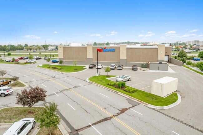
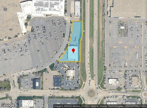
Property Detail
1890 Adams St
Mankato, MN
River Hills Mall Addition
R01.09.09.426.047
RIVER HILLS MALL ADD, PT LOT 6 BLOCK 1 BEG NW COR, SE120.44', S260.72', W238.33', NW31.8', NE ALG CURVE TO BEG & LOT 7 BLOCK
Storebuilding
Blue Earth
X
Minnesota
27013C0115F
6-7
2025
1.66 AC
2025
East Mankato
170400
Other Market Areas
18,485 SF
NEARBY LISTINGS FOR SALE OR LEASE
DEMOGRAPHICS near 1890 Adams St
1 mile
3 mile
5 mile
2024 Total Population
2,908
37,521
63,770
2029 Population
2,998
38,481
65,045
Pop Growth 2024-2029
+ 3.09%
+ 2.56%
+ 2.00%
Average Age
39
36
36
2024 Total Households
1,342
15,762
25,371
HH Growth 2024-2029
+ 3.20%
+ 2.65%
+ 2.11%
Median Household Inc
$67,446
$59,771
$65,974
Avg Household Size
2.10
2.20
2.30
2024 Avg HH Vehicles
2.00
2.00
2.00
Median Home Value
$280,962
$214,807
$222,352
Median Year Built
2000
1985
1981
Nearby Places
Map Layers
Map Styles
 Street
 Aerial
Transit
 Traffic
 Biking
Places
Listings with unknown addresses are not visible on the map
- Restaurants
- Banks
- Shops
- Fitness
- Groceries
SALE & LEASE HISTORY
LISTING DATE
SALE/LEASE

May 30, 2023
For Sale
Apr 17, 2024
For Sale
Nearby Properties
Address
Land Use
TOTAL SIZE
Lot Size
Zoning
Address
Land Use
TOTAL SIZE
Lot Size
Zoning
666,816 SF
6.31 AC
Address
Land Use
TOTAL SIZE
Lot Size
Zoning
184,270 SF
79.30 AC
Address
Land Use
TOTAL SIZE
Lot Size
Zoning
616,099 SF
4.06 AC
Address
Land Use
TOTAL SIZE
Lot Size
Zoning
178,201 SF
64.49 AC
Address
Land Use
TOTAL SIZE
Lot Size
Zoning
191,916 SF
37.68 AC
Address
Land Use
TOTAL SIZE
Lot Size
Zoning
12.37 AC
Address
Land Use
TOTAL SIZE
Lot Size
Zoning
17.90 AC
Address
Land Use
TOTAL SIZE
Lot Size
Zoning
13.43 AC
Address
Land Use
TOTAL SIZE
Lot Size
Zoning
481,569 SF
31.57 AC
Address
Land Use
TOTAL SIZE
Lot Size
Zoning
458,428 SF
138.79 AC
Address
Land Use
TOTAL SIZE
Lot Size
Zoning
11.75 AC
Address
Land Use
TOTAL SIZE
Lot Size
Zoning
287,085 SF
38 AC
Address
Land Use
TOTAL SIZE
Lot Size
Zoning
329,820 SF
18.94 AC
Address
Land Use
TOTAL SIZE
Lot Size
Zoning
101,602 SF
20 AC
Address
Land Use
TOTAL SIZE
Lot Size
Zoning
331,604 SF
35.88 AC
Address
Land Use
TOTAL SIZE
Lot Size
Zoning
47,274 SF
17.47 AC
Address
Land Use
TOTAL SIZE
Lot Size
Zoning
157,216 SF
31.67 AC
Address
Land Use
TOTAL SIZE
Lot Size
Zoning
137,968 SF
11.96 AC
Address
Land Use
TOTAL SIZE
Lot Size
Zoning
4.26 AC
Address
Land Use
TOTAL SIZE
Lot Size
Zoning
3.73 AC
Address
Land Use
TOTAL SIZE
Lot Size
Zoning
83,917 SF
10.08 AC
Address
Land Use
TOTAL SIZE
Lot Size
Zoning
168,908 SF
5.71 AC
Address
Land Use
TOTAL SIZE
Lot Size
Zoning
144,504 SF
3.87 AC
Address
Land Use
TOTAL SIZE
Lot Size
Zoning
97,508 SF
44.54 AC
Address
Land Use
TOTAL SIZE
Lot Size
Zoning
63,880 SF
9.19 AC
Address
Land Use
TOTAL SIZE
Lot Size
Zoning
6.91 AC
Address
Land Use
TOTAL SIZE
Lot Size
Zoning
6.44 AC
Address
Land Use
TOTAL SIZE
Lot Size
Zoning
58,604 SF
1.19 AC
Address
Land Use
TOTAL SIZE
Lot Size
Zoning
The World's #1 Commercial Real Estate Marketplace
Connect with us
© 2026 CoStar Group
The information above has been obtained from sources believed reliable. While we do not doubt its accuracy we have not verified it and make no guarantee, warranty or representation about it. It is your responsibility to independently confirm its accuracy and completeness. Any projections, opinions, assumptions, or estimates used are for example only and do not represent the current or future performance of the property. The value of this transaction to you depends on tax and other factors which should be evaluated by your tax, financial, and legal advisors. You and your advisors should conduct a careful, independent investigation of the property to determine to your satisfaction the suitability of the property for your needs.