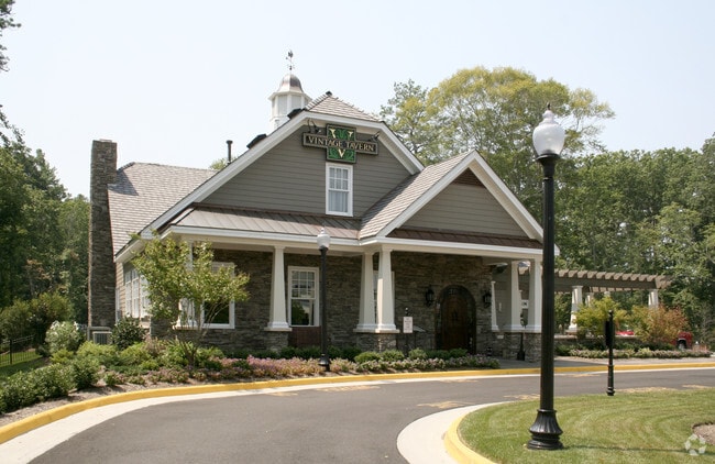
Property Record
1900 Governors Pointe Dr, Suffolk, VA 23436


NEARBY LISTINGS FOR SALE OR LEASE
Property Detail
1900 Governors Pointe Dr
253500700
Governors Pointe
Commercialnec
TRACT 2,GOVERNORS POINTE
AE
Suffolk City
5101560038E
Virginia
2025
2.70 AC
2025
Northern Suffolk
075301
Hampton Roads
5,817 SF
Virginia Beach-Norfolk-Newport News, VA-NC
DEMOGRAPHICS near 1900 Governors Pointe Dr
1 Mile
3 Mile
5 Mile
2024 Total Population
1,653
10,088
45,980
2029 Population
1,842
11,256
50,844
Pop Growth 2024-2029
+ 11.43%
+ 11.58%
+ 10.58%
Average Age
48
44
39
2024 Total Households
673
3,879
17,498
HH Growth 2024-2029
+ 11.89%
+ 11.81%
+ 10.78%
Median Household Inc
$148,181
$127,988
$103,499
Avg Household Size
2.40
2.60
2.60
2024 Avg HH Vehicles
2.00
2.00
2.00
Median Home Value
$484,070
$445,245
$352,692
Median Year Built
1981
1999
2000
Nearby Places
Map Layers
Map Styles
 Street
 Aerial
- Restaurants
- Banks
- Shops
- Fitness
- Groceries
PUBLIC TRANSPORTATION
AIRPORT
Newport News/Williamsburg International
DRIVE
WALK
Distance
Newport News/Williamsburg International
37 min
20.9 mi
Norfolk International
DRIVE
WALK
Distance
Norfolk International
37 min
21.0 mi
Freight Ports
Virginia Port Authority - Portsmouth
DRIVE
WALK
Distance
Virginia Port Authority - Portsmouth
24 min
13.2 mi
Nearby Properties
Address
Land Use
TOTAL SIZE
Lot Size
Zoning
Address
Land Use
TOTAL SIZE
Lot Size
Zoning
681,685 SF
52.59 AC
LIGHT INDU
Address
Land Use
TOTAL SIZE
Lot Size
Zoning
11.83 AC
OFFICE-INS
Address
Land Use
TOTAL SIZE
Lot Size
Zoning
1,018 SF
8.03 AC
GC
Address
Land Use
TOTAL SIZE
Lot Size
Zoning
11,246 SF
7.88 AC
RESIDENTIA
Address
Land Use
TOTAL SIZE
Lot Size
Zoning
20,175 SF
12.35 AC
GENERAL CO
Address
Land Use
TOTAL SIZE
Lot Size
Zoning
28,470 SF
5.46 AC
GENERAL CO
Address
Land Use
TOTAL SIZE
Lot Size
Zoning
2,464 SF
54.58 AC
RURAL RESI
Address
Land Use
TOTAL SIZE
Lot Size
Zoning
39,414 SF
7.90 AC
RESIDENTIA
Address
Land Use
TOTAL SIZE
Lot Size
Zoning
1,100 SF
190.54 AC
RESIDENTIA
Address
Land Use
TOTAL SIZE
Lot Size
Zoning
17,655 SF
5.42 AC
GENERAL CO
Address
Land Use
TOTAL SIZE
Lot Size
Zoning
8,936 SF
7.64 AC
GENERAL CO
Address
Land Use
TOTAL SIZE
Lot Size
Zoning
12,708 SF
1 AC
01
Address
Land Use
TOTAL SIZE
Lot Size
Zoning
5,854 SF
9.47 AC
OFFICE-INS
Address
Land Use
TOTAL SIZE
Lot Size
Zoning
3,504 SF
1 AC
GENERAL CO
Address
Land Use
TOTAL SIZE
Lot Size
Zoning
261 SF
1.30 AC
GENERAL CO
Address
Land Use
TOTAL SIZE
Lot Size
Zoning
11,562 SF
2.75 AC
RAC
Address
Land Use
TOTAL SIZE
Lot Size
Zoning
4,843 SF
3.41 AC
GENERAL CO
Address
Land Use
TOTAL SIZE
Lot Size
Zoning
5,753 SF
43.07 AC
RURAL ESTA
Address
Land Use
TOTAL SIZE
Lot Size
Zoning
9,632 SF
1.42 AC
01
Address
Land Use
TOTAL SIZE
Lot Size
Zoning
3,828 SF
4.63 AC
05
Address
Land Use
TOTAL SIZE
Lot Size
Zoning
5,346 SF
120 AC
AGRICULTUR
Address
Land Use
TOTAL SIZE
Lot Size
Zoning
4,920 SF
2.02 AC
NEIGHBORHO
Address
Land Use
TOTAL SIZE
Lot Size
Zoning
8,371 SF
1.04 AC
GENERAL CO
Address
Land Use
TOTAL SIZE
Lot Size
Zoning
13,050 SF
2.45 AC
01
The World's #1 Commercial Real Estate Marketplace
Connect with us
© 2025 CoStar Group
The information above has been obtained from sources believed reliable. While we do not doubt its accuracy we have not verified it and make no guarantee, warranty or representation about it. It is your responsibility to independently confirm its accuracy and completeness. Any projections, opinions, assumptions, or estimates used are for example only and do not represent the current or future performance of the property. The value of this transaction to you depends on tax and other factors which should be evaluated by your tax, financial, and legal advisors. You and your advisors should conduct a careful, independent investigation of the property to determine to your satisfaction the suitability of the property for your needs.