Property Record
1900 N Interstate 35E, Carrollton, TX 75006
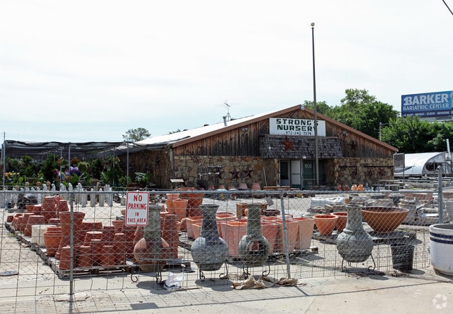

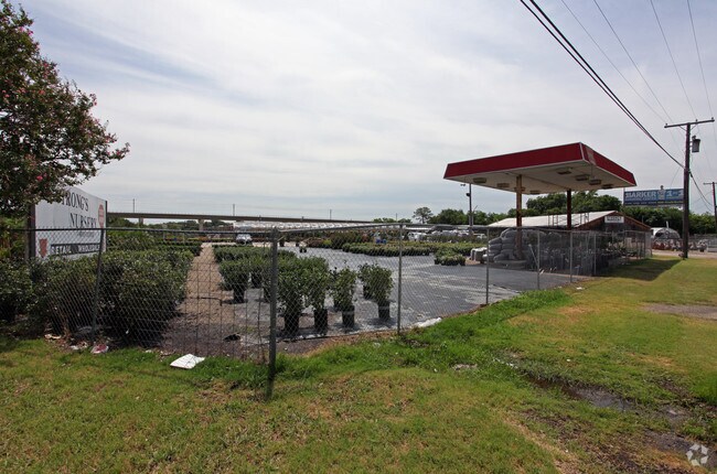
Property Detail
1900 N Interstate 35E
65051923010170000
MARTHA P GREEN ABST 519 PG 230 TR 17 ACS 1.0 VOL97118/4125 DD121394 CO-DALLAS 0519230101700 11405192301
Storebuilding
DALLAS
Z84
Texas
B and X Area of moderate flood hazard, usually the area between the limits of the 100-year and 500-year floods.
0.89 AC
2025
South Carrollton
2025
Dallas/Ft Worth
013716
Dallas-Fort Worth-Arlington, TX
5,400 SF
NEARBY LISTINGS FOR SALE OR LEASE
DEMOGRAPHICS near 1900 N Interstate 35E
1 mile
3 mile
5 mile
2025 Total Population
5,429
91,224
317,142
2030 Population
5,662
95,400
337,653
Pop Growth 2025-2030
+ 4.29%
+ 4.58%
+ 6.47%
Average Age
37
38
38
2025 Total Households
1,841
32,843
128,349
HH Growth 2025-2030
+ 4.40%
+ 4.68%
+ 6.60%
Median Household Inc
$87,885
$98,969
$97,098
Avg Household Size
2.90
2.70
2.40
2025 Avg HH Vehicles
2.00
2.00
2.00
Median Home Value
$295,293
$374,198
$422,692
Median Year Built
1977
1985
1991
Nearby Places
Map Layers
Map Styles
 Street
 Aerial
Layers
 Traffic
 Biking
Places
Listings with unknown addresses are not visible on the map
- Restaurants
- Banks
- Shops
- Fitness
- Groceries
PUBLIC TRANSPORTATION
COMMUTER RAIL
Trinity Mills Station (Green Line - Dallas Area Rapid Transit (DART))
Drive
Walk
Distance
Trinity Mills Station (Green Line - Dallas Area Rapid Transit (DART))
3 min
1.4 mi
Drive
Walk
Distance
9 min
4.4 mi
AIRPORT
Dallas Love Field
Drive
Walk
Distance
Dallas Love Field
23 min
13.9 mi
Dallas-Fort Worth International
Drive
Walk
Distance
Dallas-Fort Worth International
20 min
14.2 mi
Nearby Properties
Address
Land Use
TOTAL SIZE
Lot Size
Zoning
Address
Land Use
TOTAL SIZE
Lot Size
Zoning
660,180 SF
29.95 AC
Address
Land Use
TOTAL SIZE
Lot Size
Zoning
513,871 SF
3.63 AC
Z235
Address
Land Use
TOTAL SIZE
Lot Size
Zoning
242,707 SF
27.63 AC
Z343
Address
Land Use
TOTAL SIZE
Lot Size
Zoning
368,845 SF
20.96 AC
Z172
Address
Land Use
TOTAL SIZE
Lot Size
Zoning
544,650 SF
26.03 AC
Z177
Address
Land Use
TOTAL SIZE
Lot Size
Zoning
321,732 SF
4.05 AC
Z235
Address
Land Use
TOTAL SIZE
Lot Size
Zoning
345,320 SF
20.50 AC
Z172
Address
Land Use
TOTAL SIZE
Lot Size
Zoning
266,871 SF
87 SF
Address
Land Use
TOTAL SIZE
Lot Size
Zoning
725,972 SF
4 AC
Address
Land Use
TOTAL SIZE
Lot Size
Zoning
189,500 SF
53.90 AC
Address
Land Use
TOTAL SIZE
Lot Size
Zoning
364,670 SF
13.72 AC
Z393
Address
Land Use
TOTAL SIZE
Lot Size
Zoning
283,285 SF
16.80 AC
Z172
Address
Land Use
TOTAL SIZE
Lot Size
Zoning
292,049 SF
11.44 AC
Z243
Address
Land Use
TOTAL SIZE
Lot Size
Zoning
270,915 SF
3.91 AC
Z84
Address
Land Use
TOTAL SIZE
Lot Size
Zoning
374,093 SF
21.54 AC
Z268
Address
Land Use
TOTAL SIZE
Lot Size
Zoning
711,360 SF
32.62 AC
Address
Land Use
TOTAL SIZE
Lot Size
Zoning
350,002 SF
21.01 AC
Z172
Address
Land Use
TOTAL SIZE
Lot Size
Zoning
294,764 SF
18 AC
Address
Land Use
TOTAL SIZE
Lot Size
Zoning
242,280 SF
13.61 AC
Z176
Address
Land Use
TOTAL SIZE
Lot Size
Zoning
227,032 SF
11 AC
Z243
Address
Land Use
TOTAL SIZE
Lot Size
Zoning
188,928 SF
10.63 AC
Z243
Address
Land Use
TOTAL SIZE
Lot Size
Zoning
231,628 SF
12.21 AC
RMR2
Address
Land Use
TOTAL SIZE
Lot Size
Zoning
399,880 SF
25.21 AC
Z236
Address
Land Use
TOTAL SIZE
Lot Size
Zoning
218,630 SF
10.42 AC
Z393
Address
Land Use
TOTAL SIZE
Lot Size
Zoning
219,057 SF
12.63 AC
2B
Address
Land Use
TOTAL SIZE
Lot Size
Zoning
205,902 SF
10 AC
Z177
Address
Land Use
TOTAL SIZE
Lot Size
Zoning
232,109 SF
4.38 AC
Address
Land Use
TOTAL SIZE
Lot Size
Zoning
223,391 SF
10.90 AC
RMR2
Address
Land Use
TOTAL SIZE
Lot Size
Zoning
214,033 SF
10.39 AC
RMR2
Address
Land Use
TOTAL SIZE
Lot Size
Zoning
185,998 SF
10.68 AC
Z243
The World's #1 Commercial Real Estate Marketplace
Connect with us
© 2026 CoStar Group
The information above has been obtained from sources believed reliable. While we do not doubt its accuracy we have not verified it and make no guarantee, warranty or representation about it. It is your responsibility to independently confirm its accuracy and completeness. Any projections, opinions, assumptions, or estimates used are for example only and do not represent the current or future performance of the property. The value of this transaction to you depends on tax and other factors which should be evaluated by your tax, financial, and legal advisors. You and your advisors should conduct a careful, independent investigation of the property to determine to your satisfaction the suitability of the property for your needs.