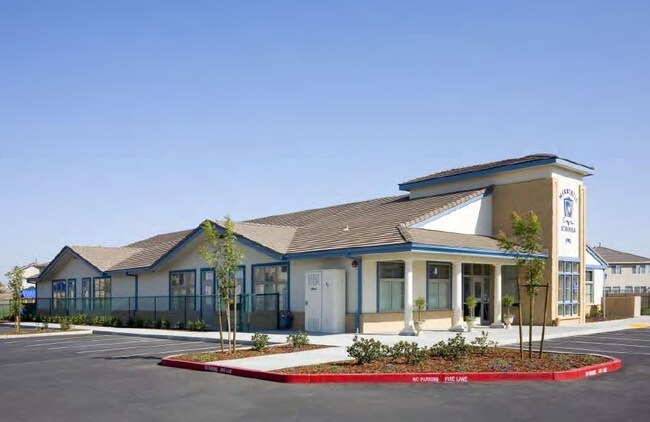
Property Record
1901 Danbrook Dr, Sacramento, CA 95835

NEARBY LISTINGS FOR SALE OR LEASE
Property Detail
1901 Danbrook Dr
Sacramento
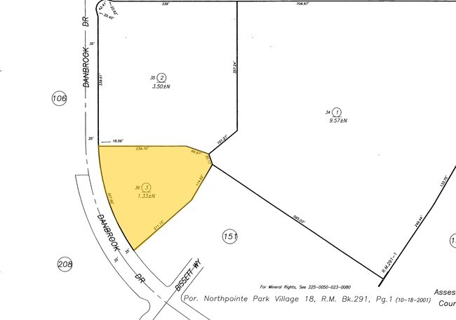
Northpointe Park Vlg 18
Sacramento--Roseville--Arden-Arcade, CA
NORTHPOINTE PARK VLG 18, LOT 36
225-1730-003
Sacramento
Daycare
California
2024
36
2025
1.33 AC
007106
Natomas
8,475 SF
DEMOGRAPHICS near 1901 Danbrook Dr
1 Mile
3 Mile
5 Mile
2024 Total Population
21,036
92,748
192,526
2029 Population
21,114
93,974
194,455
Pop Growth 2024-2029
+ 0.37%
+ 1.32%
+ 1.00%
Average Age
38
37
37
2024 Total Households
7,286
31,932
64,086
HH Growth 2024-2029
+ 0.40%
+ 1.34%
+ 1.03%
Median Household Inc
$104,015
$99,807
$85,305
Avg Household Size
2.90
2.90
2.90
2024 Avg HH Vehicles
2.00
2.00
2.00
Median Home Value
$486,396
$480,776
$445,260
Median Year Built
2004
2003
1995
Nearby Places
Map Layers
Map Styles
 Street
 Aerial
- Restaurants
- Banks
- Shops
- Fitness
- Groceries
PUBLIC TRANSPORTATION
COMMUTER RAIL
DRIVE
WALK
Distance
14 min
8.5 mi
AIRPORT
Sacramento International
DRIVE
WALK
Distance
Sacramento International
15 min
7.8 mi
Freight Ports
Port of Stockton
DRIVE
WALK
Distance
Port of Stockton
65 min
54.4 mi
Nearby Properties
Address
Land Use
TOTAL SIZE
Lot Size
Zoning
Address
Land Use
TOTAL SIZE
Lot Size
Zoning
363,761 SF
10.34 AC
SC-PUD
Address
Land Use
TOTAL SIZE
Lot Size
Zoning
522,025 SF
65.80 AC
SC-PUD EC-
Address
Land Use
TOTAL SIZE
Lot Size
Zoning
9.74 AC
EC-50-PUD
Address
Land Use
TOTAL SIZE
Lot Size
Zoning
153,090 SF
7.77 AC
MP
Address
Land Use
TOTAL SIZE
Lot Size
Zoning
343,500 SF
12.68 AC
R-2B-R-PUD
Address
Land Use
TOTAL SIZE
Lot Size
Zoning
100.41 AC
C-2-PUD
Address
Land Use
TOTAL SIZE
Lot Size
Zoning
241,321 SF
14.43 AC
R-3-PUD
Address
Land Use
TOTAL SIZE
Lot Size
Zoning
388,609 SF
14.67 AC
R-3-PUD
Address
Land Use
TOTAL SIZE
Lot Size
Zoning
6.43 AC
EC-50-PUD
Address
Land Use
TOTAL SIZE
Lot Size
Zoning
429,346 SF
18.88 AC
R-2B-PUD E
Address
Land Use
TOTAL SIZE
Lot Size
Zoning
298,493 SF
18.56 AC
EC-40-PUD
Address
Land Use
TOTAL SIZE
Lot Size
Zoning
195,928 SF
8.62 AC
EC-40-PUD
Address
Land Use
TOTAL SIZE
Lot Size
Zoning
164,061 SF
8.15 AC
R-3-PUD
Address
Land Use
TOTAL SIZE
Lot Size
Zoning
282,292 SF
14.42 AC
R-3-PUD
Address
Land Use
TOTAL SIZE
Lot Size
Zoning
327,278 SF
20.63 AC
R-2A
Address
Land Use
TOTAL SIZE
Lot Size
Zoning
6.23 AC
EC-50-PUD
Address
Land Use
TOTAL SIZE
Lot Size
Zoning
9.01 AC
EC-80-PUD
Address
Land Use
TOTAL SIZE
Lot Size
Zoning
4.29 AC
EC-50-PUD
Address
Land Use
TOTAL SIZE
Lot Size
Zoning
217,682 SF
9.57 AC
R-3-PUD
Address
Land Use
TOTAL SIZE
Lot Size
Zoning
92,240 SF
5.59 AC
MP
Address
Land Use
TOTAL SIZE
Lot Size
Zoning
209,376 SF
9.14 AC
MP M-1
Address
Land Use
TOTAL SIZE
Lot Size
Zoning
13.90 AC
SC-PUD
Address
Land Use
TOTAL SIZE
Lot Size
Zoning
Address
Land Use
TOTAL SIZE
Lot Size
Zoning
1,784 SF
15.07 AC
M-1
Address
Land Use
TOTAL SIZE
Lot Size
Zoning
222,792 SF
12.50 AC
MP
Address
Land Use
TOTAL SIZE
Lot Size
Zoning
204,999 SF
8.32 AC
R-3-PUD
Address
Land Use
TOTAL SIZE
Lot Size
Zoning
343,355 SF
19.10 AC
MP M-1
Address
Land Use
TOTAL SIZE
Lot Size
Zoning
4.55 AC
EC-50-PUD
Address
Land Use
TOTAL SIZE
Lot Size
Zoning
264,620 SF
0.68 AC
R-4-PUD
Address
Land Use
TOTAL SIZE
Lot Size
Zoning
4.19 AC
EC-65-PUD
The World's #1 Commercial Real Estate Marketplace
Connect with us
© 2025 CoStar Group
The information above has been obtained from sources believed reliable. While we do not doubt its accuracy we have not verified it and make no guarantee, warranty or representation about it. It is your responsibility to independently confirm its accuracy and completeness. Any projections, opinions, assumptions, or estimates used are for example only and do not represent the current or future performance of the property. The value of this transaction to you depends on tax and other factors which should be evaluated by your tax, financial, and legal advisors. You and your advisors should conduct a careful, independent investigation of the property to determine to your satisfaction the suitability of the property for your needs.