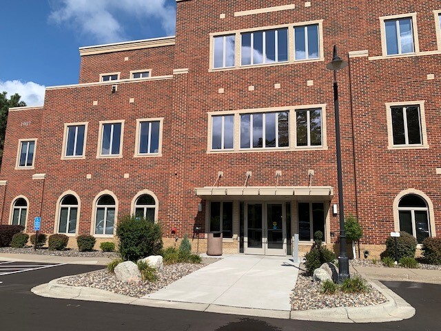
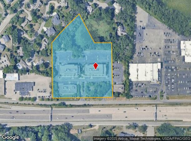
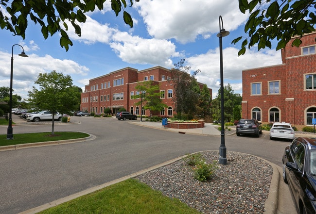
Property Record
1907 Wayzata Blvd, Wayzata, MN 55391
Current Lease Availabilities
NEARBY LISTINGS FOR SALE OR LEASE
Property Detail
1907 Wayzata Blvd
Minneapolis-St. Paul-Bloomington, MN-WI
Wayzata Executive Park
05-117-22-13-0034
LOT 001 BLOCK 001 T WAYZATA EXECUTIVE PARK IRREGULAR
Commercialnec
Hennepin
X
Minnesota
27053C0326F
1
2024
7.04 AC
2024
I-394 Corridor
027300
Minneapolis/St Paul
DEMOGRAPHICS near 1907 Wayzata Blvd
1 Mile
3 Mile
5 Mile
2024 Total Population
4,998
40,879
121,874
2029 Population
4,961
40,442
120,118
Pop Growth 2024-2029
(0.74%)
(1.07%)
(1.44%)
Average Age
45
44
43
2024 Total Households
2,313
17,223
50,823
HH Growth 2024-2029
(0.61%)
(1.10%)
(1.56%)
Median Household Inc
$116,183
$120,562
$112,861
Avg Household Size
2.10
2.30
2.30
2024 Avg HH Vehicles
2.00
2.00
2.00
Median Home Value
$612,339
$472,515
$437,335
Median Year Built
1988
1980
1980
Nearby Places
Map Layers
Map Styles
 Street
 Aerial
- Restaurants
- Banks
- Shops
- Fitness
- Groceries
PUBLIC TRANSPORTATION
AIRPORT
Minneapolis-St Paul International/Wold-Chamberlain
DRIVE
WALK
Distance
Minneapolis-St Paul International/Wold-Chamberlain
32 min
21.2 mi
Nearby Properties
Address
Land Use
TOTAL SIZE
Lot Size
Zoning
Address
Land Use
TOTAL SIZE
Lot Size
Zoning
324,564 SF
32.54 AC
PID
Address
Land Use
TOTAL SIZE
Lot Size
Zoning
18.27 AC
Address
Land Use
TOTAL SIZE
Lot Size
Zoning
20,710 SF
7.69 AC
PID
Address
Land Use
TOTAL SIZE
Lot Size
Zoning
20,710 SF
7.69 AC
PID
Address
Land Use
TOTAL SIZE
Lot Size
Zoning
6.47 AC
Address
Land Use
TOTAL SIZE
Lot Size
Zoning
19.46 AC
PUD
Address
Land Use
TOTAL SIZE
Lot Size
Zoning
202,718 SF
14.37 AC
PID
Address
Land Use
TOTAL SIZE
Lot Size
Zoning
196,498 SF
13.13 AC
PID
Address
Land Use
TOTAL SIZE
Lot Size
Zoning
11.93 AC
PID
Address
Land Use
TOTAL SIZE
Lot Size
Zoning
2.58 AC
Address
Land Use
TOTAL SIZE
Lot Size
Zoning
15.86 AC
Address
Land Use
TOTAL SIZE
Lot Size
Zoning
2.38 AC
Address
Land Use
TOTAL SIZE
Lot Size
Zoning
171,900 SF
39.17 AC
B1
Address
Land Use
TOTAL SIZE
Lot Size
Zoning
2.18 AC
Address
Land Use
TOTAL SIZE
Lot Size
Zoning
40.17 AC
Address
Land Use
TOTAL SIZE
Lot Size
Zoning
94,155 SF
2.06 AC
PUD
Address
Land Use
TOTAL SIZE
Lot Size
Zoning
2.12 AC
Address
Land Use
TOTAL SIZE
Lot Size
Zoning
14.36 AC
PID
Address
Land Use
TOTAL SIZE
Lot Size
Zoning
43,180 SF
10.28 AC
PID
Address
Land Use
TOTAL SIZE
Lot Size
Zoning
43,180 SF
10.94 AC
PID
Address
Land Use
TOTAL SIZE
Lot Size
Zoning
14,239 SF
4.44 AC
PID
Address
Land Use
TOTAL SIZE
Lot Size
Zoning
0.07 AC
Address
Land Use
TOTAL SIZE
Lot Size
Zoning
16.11 AC
Address
Land Use
TOTAL SIZE
Lot Size
Zoning
81,834 SF
16.20 AC
PID
Address
Land Use
TOTAL SIZE
Lot Size
Zoning
7.51 AC
Address
Land Use
TOTAL SIZE
Lot Size
Zoning
3.08 AC
Address
Land Use
TOTAL SIZE
Lot Size
Zoning
18.65 AC
Address
Land Use
TOTAL SIZE
Lot Size
Zoning
12.96 AC
Address
Land Use
TOTAL SIZE
Lot Size
Zoning
0.48 AC
Address
Land Use
TOTAL SIZE
Lot Size
Zoning
0.88 AC
The World's #1 Commercial Real Estate Marketplace
Connect with us
© 2025 CoStar Group
The information above has been obtained from sources believed reliable. While we do not doubt its accuracy we have not verified it and make no guarantee, warranty or representation about it. It is your responsibility to independently confirm its accuracy and completeness. Any projections, opinions, assumptions, or estimates used are for example only and do not represent the current or future performance of the property. The value of this transaction to you depends on tax and other factors which should be evaluated by your tax, financial, and legal advisors. You and your advisors should conduct a careful, independent investigation of the property to determine to your satisfaction the suitability of the property for your needs.