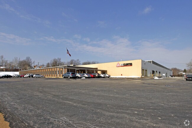
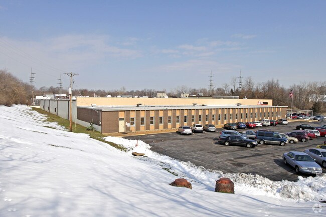
Property Record
1907 Kienlen Ave, Saint Louis, MO 63133
Property Detail
1907 Kienlen Ave
16H-34-1122
MARIA L KIENLENS LOT PTS 4 & 6 16H340976 9 16 8
Autorepair
ST. LOUIS
68COMCL
Missouri
B and X Area of moderate flood hazard, usually the area between the limits of the 100-year and 500-year floods.
4,6
2024
5.63 AC
2025
Innerbelt E of 170
213900
St. Louis
142,597 SF
St. Louis, MO-IL
NEARBY LISTINGS FOR SALE OR LEASE
DEMOGRAPHICS near 1907 Kienlen Ave
1 mile
3 mile
5 mile
2025 Total Population
12,954
129,250
310,768
2030 Population
13,473
130,414
310,356
Pop Growth 2025-2030
+ 4.01%
+ 0.90%
(0.13%)
Average Age
39
39
40
2025 Total Households
5,079
54,644
136,550
HH Growth 2025-2030
+ 3.86%
+ 0.54%
(0.58%)
Median Household Inc
$34,878
$47,747
$53,772
Avg Household Size
2.40
2.20
2.10
2025 Avg HH Vehicles
1.00
1.00
1.00
Median Home Value
$59,162
$114,964
$153,187
Median Year Built
1948
1948
1950
Nearby Places
Map Layers
Map Styles
 Street
 Aerial
Layers
 Traffic
 Biking
Places
Listings with unknown addresses are not visible on the map
- Restaurants
- Banks
- Shops
- Fitness
- Groceries
PUBLIC TRANSPORTATION
COMMUTER RAIL
Wellston (Lambert Airport Shiloh-Scott - St. Louis MetroLink (MetroLink))
Drive
Walk
Distance
Wellston (Lambert Airport Shiloh-Scott - St. Louis MetroLink (MetroLink))
3 min
1.4 mi
Rock Road (Lambert Airport Shiloh-Scott - St. Louis MetroLink (MetroLink))
Drive
Walk
Distance
Rock Road (Lambert Airport Shiloh-Scott - St. Louis MetroLink (MetroLink))
3 min
1.6 mi
AIRPORT
St Louis Lambert International
Drive
Walk
Distance
St Louis Lambert International
13 min
7.5 mi
Scott AFB/Midamerica St Louis
Drive
Walk
Distance
Scott AFB/Midamerica St Louis
49 min
32.1 mi
Freight Ports
Port Milwaukee
Drive
Walk
Distance
Port Milwaukee
427 min
373.9 mi
Nearby Properties
Address
Land Use
TOTAL SIZE
Lot Size
Zoning
Address
Land Use
TOTAL SIZE
Lot Size
Zoning
684,846 SF
90.65 AC
R6
Address
Land Use
TOTAL SIZE
Lot Size
Zoning
Address
Land Use
TOTAL SIZE
Lot Size
Zoning
124.96 AC
J
Address
Land Use
TOTAL SIZE
Lot Size
Zoning
558,158 SF
45.66 AC
14R-2
Address
Land Use
TOTAL SIZE
Lot Size
Zoning
152.07 AC
L
Address
Land Use
TOTAL SIZE
Lot Size
Zoning
72,612 SF
118.34 AC
3INSTU
Address
Land Use
TOTAL SIZE
Lot Size
Zoning
390,010 SF
13.25 AC
R6
Address
Land Use
TOTAL SIZE
Lot Size
Zoning
7.94 AC
D
Address
Land Use
TOTAL SIZE
Lot Size
Zoning
225,920 SF
2.02 AC
H
Address
Land Use
TOTAL SIZE
Lot Size
Zoning
15.27 AC
A
Address
Land Use
TOTAL SIZE
Lot Size
Zoning
248,809 SF
3.23 AC
H
Address
Land Use
TOTAL SIZE
Lot Size
Zoning
19.40 AC
57PA
Address
Land Use
TOTAL SIZE
Lot Size
Zoning
348,233 SF
23.68 AC
Address
Land Use
TOTAL SIZE
Lot Size
Zoning
101,200 SF
1.10 AC
E
Address
Land Use
TOTAL SIZE
Lot Size
Zoning
46.18 AC
A
Address
Land Use
TOTAL SIZE
Lot Size
Zoning
121,418 SF
1.28 AC
H
Address
Land Use
TOTAL SIZE
Lot Size
Zoning
18.32 AC
PA
Address
Land Use
TOTAL SIZE
Lot Size
Zoning
151,640 SF
5.38 AC
D
Address
Land Use
TOTAL SIZE
Lot Size
Zoning
94,364 SF
0.44 AC
H
Address
Land Use
TOTAL SIZE
Lot Size
Zoning
0.73 AC
B
Address
Land Use
TOTAL SIZE
Lot Size
Zoning
5,640 SF
10.42 AC
A
Address
Land Use
TOTAL SIZE
Lot Size
Zoning
223,395 SF
1.41 AC
H
Address
Land Use
TOTAL SIZE
Lot Size
Zoning
167,174 SF
1.23 AC
E
Address
Land Use
TOTAL SIZE
Lot Size
Zoning
19.94 AC
39SFR
Address
Land Use
TOTAL SIZE
Lot Size
Zoning
15,149 SF
120.85 AC
A
Address
Land Use
TOTAL SIZE
Lot Size
Zoning
51,460 SF
101.96 AC
K
Address
Land Use
TOTAL SIZE
Lot Size
Zoning
3.79 AC
PA
Address
Land Use
TOTAL SIZE
Lot Size
Zoning
148,683 SF
2.58 AC
57HDR
Address
Land Use
TOTAL SIZE
Lot Size
Zoning
27.96 AC
NU
Address
Land Use
TOTAL SIZE
Lot Size
Zoning
255,332 SF
1.26 AC
E
The World's #1 Commercial Real Estate Marketplace
Connect with us
© 2026 CoStar Group
The information above has been obtained from sources believed reliable. While we do not doubt its accuracy we have not verified it and make no guarantee, warranty or representation about it. It is your responsibility to independently confirm its accuracy and completeness. Any projections, opinions, assumptions, or estimates used are for example only and do not represent the current or future performance of the property. The value of this transaction to you depends on tax and other factors which should be evaluated by your tax, financial, and legal advisors. You and your advisors should conduct a careful, independent investigation of the property to determine to your satisfaction the suitability of the property for your needs.