Property Record
1915 60Th Pl E, Bradenton, FL 34203
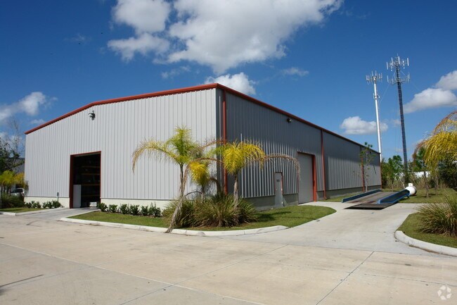


Property Detail
1915 60Th Pl E
18471-4040-9
UNIT 7 PINES INDUSTRIAL PARK, PI#18471.4040/9
Warehouse
Manatee
HM HEAVY M
Florida
C and X Area of minimal flood hazard, usually depicted on FIRMs as above the 500-year flood level.
7
2024
0.37 AC
2025
Manatee
000805
Tampa/St Petersburg
9,750 SF
North Port-Bradenton-Sarasota, FL
NEARBY LISTINGS FOR SALE OR LEASE
DEMOGRAPHICS near 1915 60Th Pl E
1 mile
3 mile
5 mile
2025 Total Population
7,327
85,480
208,834
2030 Population
8,032
94,866
231,830
Pop Growth 2025-2030
+ 9.62%
+ 10.98%
+ 11.01%
Average Age
36
45
45
2025 Total Households
2,333
35,600
90,335
HH Growth 2025-2030
+ 9.90%
+ 11.33%
+ 11.38%
Median Household Inc
$44,454
$58,614
$61,671
Avg Household Size
2.80
2.30
2.20
2025 Avg HH Vehicles
2.00
2.00
2.00
Median Home Value
$264,874
$272,573
$313,275
Median Year Built
1981
1982
1984
Nearby Places
Map Layers
Map Styles
 Street
 Aerial
Layers
 Traffic
 Biking
Places
Listings with unknown addresses are not visible on the map
- Restaurants
- Banks
- Shops
- Fitness
- Groceries
PUBLIC TRANSPORTATION
AIRPORT
Sarasota/Bradenton International
Drive
Walk
Distance
Sarasota/Bradenton International
13 min
5.7 mi
St Pete-Clearwater International
Drive
Walk
Distance
St Pete-Clearwater International
57 min
41.7 mi
Freight Ports
Port Manatee
Drive
Walk
Distance
Port Manatee
30 min
17.8 mi
Nearby Properties
Address
Land Use
TOTAL SIZE
Lot Size
Zoning
Address
Land Use
TOTAL SIZE
Lot Size
Zoning
1,023,770 SF
76.55 AC
Address
Land Use
TOTAL SIZE
Lot Size
Zoning
385,610 SF
32.65 AC
RMF-6 MULT
Address
Land Use
TOTAL SIZE
Lot Size
Zoning
331,241 SF
44.24 AC
Address
Land Use
TOTAL SIZE
Lot Size
Zoning
507,194 SF
8.49 AC
Address
Land Use
TOTAL SIZE
Lot Size
Zoning
331,816 SF
574.64 AC
Address
Land Use
TOTAL SIZE
Lot Size
Zoning
296,612 SF
576.25 AC
PD-MU
Address
Land Use
TOTAL SIZE
Lot Size
Zoning
294,609 SF
19.15 AC
RMF9
Address
Land Use
TOTAL SIZE
Lot Size
Zoning
375,171 SF
20 AC
PD-MU
Address
Land Use
TOTAL SIZE
Lot Size
Zoning
397,863 SF
21.60 AC
GC GENERA
Address
Land Use
TOTAL SIZE
Lot Size
Zoning
238,774 SF
15.56 AC
A-1 SUBURB
Address
Land Use
TOTAL SIZE
Lot Size
Zoning
115,400 SF
22.55 AC
LM LIGHT M
Address
Land Use
TOTAL SIZE
Lot Size
Zoning
359,950 SF
34.91 AC
LM LIGHT M
Address
Land Use
TOTAL SIZE
Lot Size
Zoning
187,000 SF
8.93 AC
Address
Land Use
TOTAL SIZE
Lot Size
Zoning
214,350 SF
16.07 AC
LM LIGHT M
Address
Land Use
TOTAL SIZE
Lot Size
Zoning
296,983 SF
34.84 AC
PD-MU
Address
Land Use
TOTAL SIZE
Lot Size
Zoning
485,150 SF
56.44 AC
HC,GC
Address
Land Use
TOTAL SIZE
Lot Size
Zoning
163,394 SF
15.49 AC
PD-MU
Address
Land Use
TOTAL SIZE
Lot Size
Zoning
179,042 SF
6.60 AC
PD-MU
Address
Land Use
TOTAL SIZE
Lot Size
Zoning
318,009 SF
34.60 AC
LM LIGHT M
Address
Land Use
TOTAL SIZE
Lot Size
Zoning
901,196 SF
48.54 AC
LM LIGHT M
Address
Land Use
TOTAL SIZE
Lot Size
Zoning
271,970 SF
31.11 AC
PD-I
Address
Land Use
TOTAL SIZE
Lot Size
Zoning
145,200 SF
8.66 AC
Address
Land Use
TOTAL SIZE
Lot Size
Zoning
126,505 SF
20 AC
RSF-2
Address
Land Use
TOTAL SIZE
Lot Size
Zoning
112,857 SF
10.12 AC
GC GENERA
Address
Land Use
TOTAL SIZE
Lot Size
Zoning
419,956 SF
18.46 AC
LM LIGHT M
Address
Land Use
TOTAL SIZE
Lot Size
Zoning
145,200 SF
8.99 AC
Address
Land Use
TOTAL SIZE
Lot Size
Zoning
157,713 SF
12.84 AC
GC GENERA
Address
Land Use
TOTAL SIZE
Lot Size
Zoning
124,129 SF
23.29 AC
PDC
Address
Land Use
TOTAL SIZE
Lot Size
Zoning
143,582 SF
14.42 AC
LM LIGHT M
Address
Land Use
TOTAL SIZE
Lot Size
Zoning
231,364 SF
27.50 AC
PD-PI
The World's #1 Commercial Real Estate Marketplace
Connect with us
© 2026 CoStar Group
The information above has been obtained from sources believed reliable. While we do not doubt its accuracy we have not verified it and make no guarantee, warranty or representation about it. It is your responsibility to independently confirm its accuracy and completeness. Any projections, opinions, assumptions, or estimates used are for example only and do not represent the current or future performance of the property. The value of this transaction to you depends on tax and other factors which should be evaluated by your tax, financial, and legal advisors. You and your advisors should conduct a careful, independent investigation of the property to determine to your satisfaction the suitability of the property for your needs.