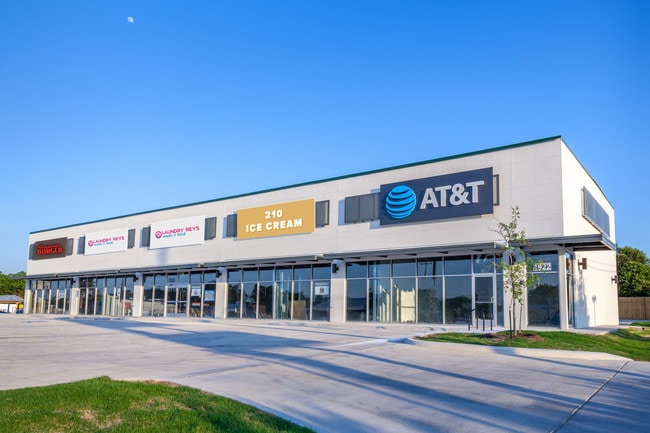
Property Record
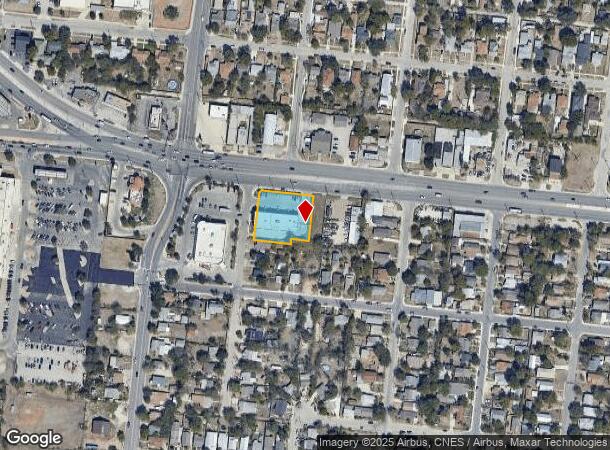
1922 Culebra Rd, San Antonio, TX 78201
NEARBY LISTINGS FOR SALE OR LEASE
Property Detail
1922 Culebra Rd
San Antonio-New Braunfels, TX
Ncb 6589 (Two Fools)
06589-006-0110
NCB 6589 (TWO FOOLS), BLOCK 6 LOT 11 2019 - CREATED PER PLAT 20001/157 FILED 06/08/2018.
Regionalshoppingcenterormallwithanchorstore
Bexar
X
Texas
48029C0383H
11
2024
0.70 AC
2025
Northwest
170401
San Antonio
6,964 SF
DEMOGRAPHICS near 1922 Culebra Rd
1 Mile
3 Mile
5 Mile
2024 Total Population
18,051
161,709
360,451
2029 Population
19,094
171,143
383,567
Pop Growth 2024-2029
+ 5.78%
+ 5.83%
+ 6.41%
Average Age
38
38
38
2024 Total Households
6,150
56,587
135,151
HH Growth 2024-2029
+ 5.89%
+ 6.14%
+ 6.84%
Median Household Inc
$40,695
$36,267
$41,482
Avg Household Size
2.80
2.70
2.50
2024 Avg HH Vehicles
2.00
2.00
2.00
Median Home Value
$113,021
$127,070
$152,079
Median Year Built
1953
1956
1963
Nearby Places
Map Layers
Map Styles
 Street
 Aerial
- Restaurants
- Banks
- Shops
- Fitness
- Groceries
PUBLIC TRANSPORTATION
COMMUTER RAIL
San Antonio Amtrak Station (Sunset Limited - Amtrak, Texas Eagle - Amtrak)
DRIVE
WALK
Distance
San Antonio Amtrak Station (Sunset Limited - Amtrak, Texas Eagle - Amtrak)
9 min
4.9 mi
AIRPORT
San Antonio International
DRIVE
WALK
Distance
San Antonio International
15 min
9.7 mi
Freight Ports
Calhoun Port
DRIVE
WALK
Distance
Calhoun Port
186 min
152.3 mi
SALE & LEASE HISTORY
LISTING DATE
SALE/LEASE

Jun 20, 2019
For Sale
Aug 17, 2022
For Lease
Apr 15, 2017
For Lease
Nearby Properties
Address
Land Use
TOTAL SIZE
Lot Size
Zoning
Address
Land Use
TOTAL SIZE
Lot Size
Zoning
443,560 SF
2.77 AC
Address
Land Use
TOTAL SIZE
Lot Size
Zoning
31,334 SF
14.11 AC
Address
Land Use
TOTAL SIZE
Lot Size
Zoning
50.69 AC
Address
Land Use
TOTAL SIZE
Lot Size
Zoning
7,542 SF
1.30 AC
Address
Land Use
TOTAL SIZE
Lot Size
Zoning
122,292 SF
12.83 AC
Address
Land Use
TOTAL SIZE
Lot Size
Zoning
12.06 AC
Address
Land Use
TOTAL SIZE
Lot Size
Zoning
245,371 SF
20.50 AC
Address
Land Use
TOTAL SIZE
Lot Size
Zoning
Address
Land Use
TOTAL SIZE
Lot Size
Zoning
98,208 SF
0.94 AC
Address
Land Use
TOTAL SIZE
Lot Size
Zoning
317,878 SF
3.14 AC
Address
Land Use
TOTAL SIZE
Lot Size
Zoning
Address
Land Use
TOTAL SIZE
Lot Size
Zoning
5,330 SF
2.53 AC
Address
Land Use
TOTAL SIZE
Lot Size
Zoning
27,517 SF
27.66 AC
Address
Land Use
TOTAL SIZE
Lot Size
Zoning
Address
Land Use
TOTAL SIZE
Lot Size
Zoning
223,148 SF
19.15 AC
Address
Land Use
TOTAL SIZE
Lot Size
Zoning
99,538 SF
11.89 AC
Address
Land Use
TOTAL SIZE
Lot Size
Zoning
102,456 SF
7.35 AC
Address
Land Use
TOTAL SIZE
Lot Size
Zoning
173,363 SF
10.29 AC
Address
Land Use
TOTAL SIZE
Lot Size
Zoning
315,630 SF
10.19 AC
Address
Land Use
TOTAL SIZE
Lot Size
Zoning
369,600 SF
1.71 AC
Address
Land Use
TOTAL SIZE
Lot Size
Zoning
153,244 SF
2.04 AC
Address
Land Use
TOTAL SIZE
Lot Size
Zoning
75,670 SF
2.48 AC
Address
Land Use
TOTAL SIZE
Lot Size
Zoning
125,776 SF
6.98 AC
Address
Land Use
TOTAL SIZE
Lot Size
Zoning
148,206 SF
7.69 AC
Address
Land Use
TOTAL SIZE
Lot Size
Zoning
179,276 SF
20.19 AC
Address
Land Use
TOTAL SIZE
Lot Size
Zoning
143,212 SF
14.85 AC
Address
Land Use
TOTAL SIZE
Lot Size
Zoning
104,146 SF
4.20 AC
Address
Land Use
TOTAL SIZE
Lot Size
Zoning
70,685 SF
1.64 AC
Address
Land Use
TOTAL SIZE
Lot Size
Zoning
245,574 SF
19.65 AC
Address
Land Use
TOTAL SIZE
Lot Size
Zoning
133,892 SF
7.41 AC
The World's #1 Commercial Real Estate Marketplace
Connect with us
© 2026 CoStar Group
The information above has been obtained from sources believed reliable. While we do not doubt its accuracy we have not verified it and make no guarantee, warranty or representation about it. It is your responsibility to independently confirm its accuracy and completeness. Any projections, opinions, assumptions, or estimates used are for example only and do not represent the current or future performance of the property. The value of this transaction to you depends on tax and other factors which should be evaluated by your tax, financial, and legal advisors. You and your advisors should conduct a careful, independent investigation of the property to determine to your satisfaction the suitability of the property for your needs.