Property Record
1930 E Brown Rd, Mesa, AZ 85203
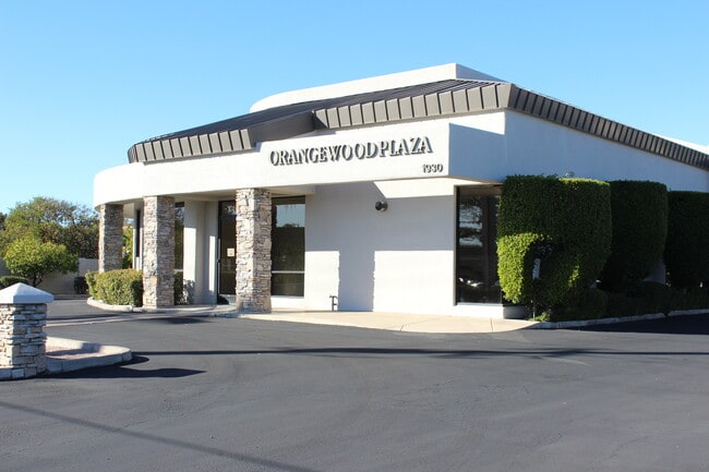

Property Detail
1930 E Brown Rd
136-27-010D
W 154F OF E 502.50F OF S 283F OF SE4 SE4 EX S 65F RD
Officebuilding
Maricopa
C-O
Arizona
C and X Area of minimal flood hazard, usually depicted on FIRMs as above the 500-year flood level.
0.77 AC
2025
Mesa East
2025
Phoenix
420604
Phoenix-Mesa-Chandler, AZ
6,274 SF
NEARBY LISTINGS FOR SALE OR LEASE
DEMOGRAPHICS near 1930 E Brown Rd
1 mile
3 mile
5 mile
2024 Total Population
14,153
144,554
296,747
2029 Population
14,566
150,744
308,512
Pop Growth 2024-2029
+ 2.92%
+ 4.28%
+ 3.96%
Average Age
39
38
39
2024 Total Households
4,664
51,786
111,103
HH Growth 2024-2029
+ 2.85%
+ 4.71%
+ 4.33%
Median Household Inc
$111,230
$72,173
$71,580
Avg Household Size
2.90
2.70
2.60
2024 Avg HH Vehicles
2.00
2.00
2.00
Median Home Value
$474,663
$405,697
$392,580
Median Year Built
1976
1983
1983
Nearby Places
Map Layers
Map Styles
 Street
 Aerial
Transit
 Traffic
 Biking
Places
Listings with unknown addresses are not visible on the map
- Restaurants
- Banks
- Shops
- Fitness
- Groceries
PUBLIC TRANSPORTATION
AIRPORT
Phoenix Sky Harbor International
Drive
Walk
Distance
Phoenix Sky Harbor International
23 min
14.3 mi
Phoenix-Mesa Gateway
Drive
Walk
Distance
Phoenix-Mesa Gateway
26 min
16.1 mi
Freight Ports
Port of San Diego
Drive
Walk
Distance
Port of San Diego
417 min
378.1 mi
SALE & LEASE HISTORY
LISTING DATE
SALE/LEASE

Sep 05, 2017
For Sale
Oct 23, 2025
For Lease
Nov 15, 2019
For Lease
Mar 29, 2018
For Sale
Nearby Properties
Address
Land Use
TOTAL SIZE
Lot Size
Zoning
Address
Land Use
TOTAL SIZE
Lot Size
Zoning
181.80 AC
Address
Land Use
TOTAL SIZE
Lot Size
Zoning
125,356 SF
21.63 AC
R-9
Address
Land Use
TOTAL SIZE
Lot Size
Zoning
11,722 SF
182.53 AC
PS
Address
Land Use
TOTAL SIZE
Lot Size
Zoning
377,442 SF
0.21 AC
C-DT
Address
Land Use
TOTAL SIZE
Lot Size
Zoning
400,798 SF
55.94 AC
PF
Address
Land Use
TOTAL SIZE
Lot Size
Zoning
579,506 SF
17.78 AC
PF
Address
Land Use
TOTAL SIZE
Lot Size
Zoning
20.08 AC
Address
Land Use
TOTAL SIZE
Lot Size
Zoning
161,388 SF
32.52 AC
R-35
Address
Land Use
TOTAL SIZE
Lot Size
Zoning
427,210 SF
38.33 AC
PF
Address
Land Use
TOTAL SIZE
Lot Size
Zoning
1.46 AC
C-G
Address
Land Use
TOTAL SIZE
Lot Size
Zoning
478,411 SF
4.07 AC
CDT
Address
Land Use
TOTAL SIZE
Lot Size
Zoning
199,472 SF
4.79 AC
C-DT
Address
Land Use
TOTAL SIZE
Lot Size
Zoning
79,452 SF
37.59 AC
PF
Address
Land Use
TOTAL SIZE
Lot Size
Zoning
169,128 SF
27.30 AC
R-9
Address
Land Use
TOTAL SIZE
Lot Size
Zoning
147,408 SF
34.58 AC
PF
Address
Land Use
TOTAL SIZE
Lot Size
Zoning
536,470 SF
28.81 AC
M-H
Address
Land Use
TOTAL SIZE
Lot Size
Zoning
349,318 SF
18.47 AC
M-H
Address
Land Use
TOTAL SIZE
Lot Size
Zoning
160,843 SF
22.07 AC
PF
Address
Land Use
TOTAL SIZE
Lot Size
Zoning
266,240 SF
9.75 AC
M-H
Address
Land Use
TOTAL SIZE
Lot Size
Zoning
321,591 SF
15.68 AC
M-H
Address
Land Use
TOTAL SIZE
Lot Size
Zoning
108,672 SF
1.59 AC
CDT
Address
Land Use
TOTAL SIZE
Lot Size
Zoning
81,000 SF
15.70 AC
AG
Address
Land Use
TOTAL SIZE
Lot Size
Zoning
403,809 SF
9.68 AC
C-DT
Address
Land Use
TOTAL SIZE
Lot Size
Zoning
203,299 SF
3.63 AC
C-DT
Address
Land Use
TOTAL SIZE
Lot Size
Zoning
103,086 SF
31.49 AC
PF
Address
Land Use
TOTAL SIZE
Lot Size
Zoning
301,051 SF
6.89 AC
M-H
Address
Land Use
TOTAL SIZE
Lot Size
Zoning
113,276 SF
1.25 AC
C-DT
Address
Land Use
TOTAL SIZE
Lot Size
Zoning
918 SF
2.22 AC
R-TC
Address
Land Use
TOTAL SIZE
Lot Size
Zoning
89,043 SF
1.97 AC
M-H
Address
Land Use
TOTAL SIZE
Lot Size
Zoning
10 SF
0.91 AC
AG
The World's #1 Commercial Real Estate Marketplace
Connect with us
© 2026 CoStar Group
The information above has been obtained from sources believed reliable. While we do not doubt its accuracy we have not verified it and make no guarantee, warranty or representation about it. It is your responsibility to independently confirm its accuracy and completeness. Any projections, opinions, assumptions, or estimates used are for example only and do not represent the current or future performance of the property. The value of this transaction to you depends on tax and other factors which should be evaluated by your tax, financial, and legal advisors. You and your advisors should conduct a careful, independent investigation of the property to determine to your satisfaction the suitability of the property for your needs.