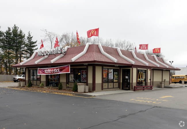
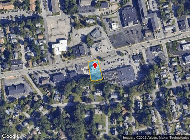
Property Record
1930 Mineral Spring Ave, Providence, RI 02904

NEARBY LISTINGS FOR SALE OR LEASE
Property Detail
1930 Mineral Spring Ave
NPRO-000018-000000-000482
Providence
Commercialbuilding
Rhode Island
X
482
44007C0301H
0.42 AC
2025
North Providence
2025
Providence
002802
Providence-Warwick, RI-MA
3,240 SF
DEMOGRAPHICS near 1930 Mineral Spring Ave
1 Mile
3 Mile
5 Mile
2024 Total Population
18,849
124,961
326,118
2029 Population
18,857
124,054
323,157
Pop Growth 2024-2029
+ 0.04%
(0.73%)
(0.91%)
Average Age
44
39
38
2024 Total Households
8,606
49,560
128,080
HH Growth 2024-2029
+ 0.05%
(0.80%)
(0.84%)
Median Household Inc
$72,349
$68,416
$63,283
Avg Household Size
2.10
2.40
2.40
2024 Avg HH Vehicles
2.00
2.00
1.00
Median Home Value
$295,299
$281,208
$308,816
Median Year Built
1971
1958
1953
Nearby Places
Map Layers
Map Styles
 Street
 Aerial
- Restaurants
- Banks
- Shops
- Fitness
- Groceries
PUBLIC TRANSPORTATION
COMMUTER RAIL
DRIVE
WALK
Distance
8 min
4.5 mi
Providence (Providence/Stoughton Line - Massachusetts Bay Transportation Authority Commuter Rail (Purple Line))
DRIVE
WALK
Distance
Providence (Providence/Stoughton Line - Massachusetts Bay Transportation Authority Commuter Rail (Purple Line))
9 min
5.1 mi
AIRPORT
Rhode Island Tf Green International
DRIVE
WALK
Distance
Rhode Island Tf Green International
24 min
13.3 mi
Worcester Regional
DRIVE
WALK
Distance
Worcester Regional
57 min
42.9 mi
Nearby Properties
Address
Land Use
TOTAL SIZE
Lot Size
Zoning
Address
Land Use
TOTAL SIZE
Lot Size
Zoning
268,679 SF
8.64 AC
I-1-75
Address
Land Use
TOTAL SIZE
Lot Size
Zoning
12.90 AC
I-2
Address
Land Use
TOTAL SIZE
Lot Size
Zoning
20.05 AC
I-2
Address
Land Use
TOTAL SIZE
Lot Size
Zoning
254,488 SF
17.50 AC
IS
Address
Land Use
TOTAL SIZE
Lot Size
Zoning
28.92 AC
PS
Address
Land Use
TOTAL SIZE
Lot Size
Zoning
53.18 AC
C
Address
Land Use
TOTAL SIZE
Lot Size
Zoning
9.06 AC
PS
Address
Land Use
TOTAL SIZE
Lot Size
Zoning
123.25 AC
R40
Address
Land Use
TOTAL SIZE
Lot Size
Zoning
200.05 AC
RA40
Address
Land Use
TOTAL SIZE
Lot Size
Zoning
301,035 SF
21.69 AC
15
Address
Land Use
TOTAL SIZE
Lot Size
Zoning
1,792 SF
28.46 AC
Address
Land Use
TOTAL SIZE
Lot Size
Zoning
159,028 SF
12.09 AC
RG
Address
Land Use
TOTAL SIZE
Lot Size
Zoning
3.88 AC
M-MU-7
Address
Land Use
TOTAL SIZE
Lot Size
Zoning
288,736 SF
11.99 AC
RG
Address
Land Use
TOTAL SIZE
Lot Size
Zoning
30.14 AC
R40
Address
Land Use
TOTAL SIZE
Lot Size
Zoning
11.43 AC
I-2
Address
Land Use
TOTAL SIZE
Lot Size
Zoning
15.57 AC
M-MU-7
Address
Land Use
TOTAL SIZE
Lot Size
Zoning
63.33 AC
OS
Address
Land Use
TOTAL SIZE
Lot Size
Zoning
8.96 AC
I-2
Address
Land Use
TOTAL SIZE
Lot Size
Zoning
237,440 SF
19.31 AC
IS
Address
Land Use
TOTAL SIZE
Lot Size
Zoning
175,231 SF
9.37 AC
Address
Land Use
TOTAL SIZE
Lot Size
Zoning
5.54 AC
R-4
Address
Land Use
TOTAL SIZE
Lot Size
Zoning
3.07 AC
M-MU-7
Address
Land Use
TOTAL SIZE
Lot Size
Zoning
153,075 SF
I-1-75
Address
Land Use
TOTAL SIZE
Lot Size
Zoning
139,630 SF
5.24 AC
PS
Address
Land Use
TOTAL SIZE
Lot Size
Zoning
21.74 AC
I-2
Address
Land Use
TOTAL SIZE
Lot Size
Zoning
69.31 AC
OS
Address
Land Use
TOTAL SIZE
Lot Size
Zoning
3.40 AC
R-3
Address
Land Use
TOTAL SIZE
Lot Size
Zoning
12.96 AC
R-4
Address
Land Use
TOTAL SIZE
Lot Size
Zoning
58,134 SF
5 AC
I-2
The World's #1 Commercial Real Estate Marketplace
Connect with us
© 2025 CoStar Group
The information above has been obtained from sources believed reliable. While we do not doubt its accuracy we have not verified it and make no guarantee, warranty or representation about it. It is your responsibility to independently confirm its accuracy and completeness. Any projections, opinions, assumptions, or estimates used are for example only and do not represent the current or future performance of the property. The value of this transaction to you depends on tax and other factors which should be evaluated by your tax, financial, and legal advisors. You and your advisors should conduct a careful, independent investigation of the property to determine to your satisfaction the suitability of the property for your needs.