Property Record
1930 State Route 57, Hackettstown, NJ 07840
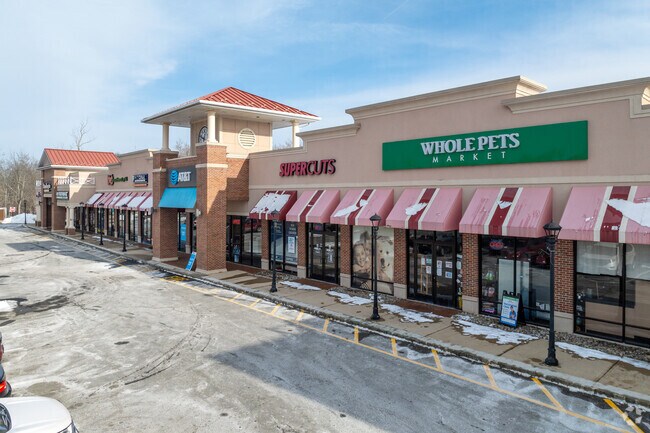

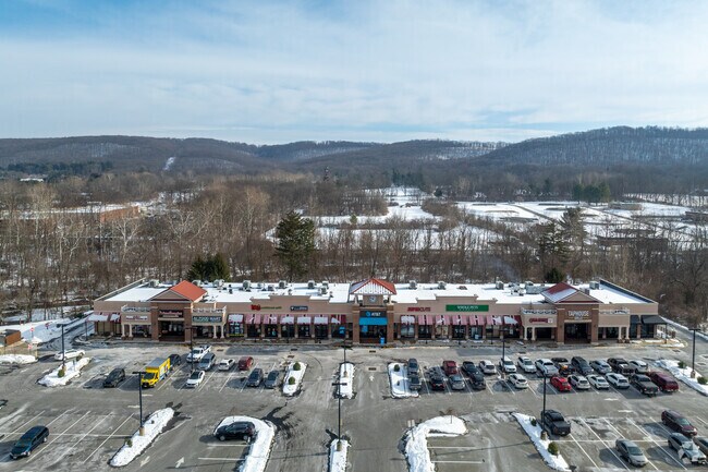
Property Detail
1930 State Route 57
Allentown-Bethlehem-Easton, PA-NJ
Warren
16-01104-0000-00010
New Jersey
Commercialnec
10
AE The base floodplain where base flood elevations are provided. AE Zones are now used on new format FIRMs instead of A1-A30 Zones.
6.72 AC
2024
Warren County
2025
Northern New Jersey
031500
NEARBY LISTINGS FOR SALE OR LEASE
DEMOGRAPHICS near 1930 State Route 57
1 mile
3 mile
5 mile
2025 Total Population
3,890
24,705
41,923
2030 Population
3,898
24,975
42,453
Pop Growth 2025-2030
+ 0.21%
+ 1.09%
+ 1.26%
Average Age
43
42
43
2025 Total Households
1,628
9,265
15,690
HH Growth 2025-2030
+ 0.06%
+ 1.10%
+ 1.30%
Median Household Inc
$107,784
$115,321
$120,599
Avg Household Size
2.30
2.60
2.60
2025 Avg HH Vehicles
2.00
2.00
2.00
Median Home Value
$451,694
$448,239
$454,516
Median Year Built
1982
1976
1978
Nearby Places
Map Layers
Map Styles
 Street
 Aerial
Layers
 Traffic
 Biking
Places
Listings with unknown addresses are not visible on the map
- Restaurants
- Banks
- Shops
- Fitness
- Groceries
PUBLIC TRANSPORTATION
COMMUTER RAIL
Hackettstown (Montclair-Boonton Line - NJ Transit Commuter Rail (NJ Transit), Morris & Essex Morristown Line - NJ Transit Commuter Rail (NJ Transit))
Drive
Walk
Distance
Hackettstown (Montclair-Boonton Line - NJ Transit Commuter Rail (NJ Transit), Morris & Essex Morristown Line - NJ Transit Commuter Rail (NJ Transit))
8 min
3.2 mi
AIRPORT
Lehigh Valley International
Drive
Walk
Distance
Lehigh Valley International
62 min
36.7 mi
Newark Liberty International
Drive
Walk
Distance
Newark Liberty International
64 min
44.0 mi
Freight Ports
Maher Terminal
Drive
Walk
Distance
Maher Terminal
69 min
44.6 mi
SALE & LEASE HISTORY
LISTING DATE
SALE/LEASE

May 02, 2019
For Lease
Jun 26, 2018
For Lease
Feb 19, 2019
For Lease
Nearby Properties
Address
Land Use
TOTAL SIZE
Lot Size
Zoning
Address
Land Use
TOTAL SIZE
Lot Size
Zoning
16,916 SF
39.96 AC
R30
Address
Land Use
TOTAL SIZE
Lot Size
Zoning
Address
Land Use
TOTAL SIZE
Lot Size
Zoning
1,798 SF
46.98 AC
R-1
Address
Land Use
TOTAL SIZE
Lot Size
Zoning
122,877 SF
36.64 AC
B-2
Address
Land Use
TOTAL SIZE
Lot Size
Zoning
255,000 SF
39.57 AC
Address
Land Use
TOTAL SIZE
Lot Size
Zoning
133,042 SF
23.25 AC
HC
Address
Land Use
TOTAL SIZE
Lot Size
Zoning
5.02 AC
R-1
Address
Land Use
TOTAL SIZE
Lot Size
Zoning
Address
Land Use
TOTAL SIZE
Lot Size
Zoning
29.81 AC
OR/I
Address
Land Use
TOTAL SIZE
Lot Size
Zoning
12.60 AC
R1R2
Address
Land Use
TOTAL SIZE
Lot Size
Zoning
6.80 AC
C2
Address
Land Use
TOTAL SIZE
Lot Size
Zoning
156,298 SF
16.96 AC
Address
Land Use
TOTAL SIZE
Lot Size
Zoning
127,307 SF
26.84 AC
C2
Address
Land Use
TOTAL SIZE
Lot Size
Zoning
13.51 AC
RCH
Address
Land Use
TOTAL SIZE
Lot Size
Zoning
1,352 SF
166.25 AC
C
Address
Land Use
TOTAL SIZE
Lot Size
Zoning
116,386 SF
33.90 AC
R125
Address
Land Use
TOTAL SIZE
Lot Size
Zoning
15,760 SF
5.47 AC
APT
Address
Land Use
TOTAL SIZE
Lot Size
Zoning
2,046 SF
13.54 AC
C2
Address
Land Use
TOTAL SIZE
Lot Size
Zoning
1,908 SF
6.35 AC
HC
Address
Land Use
TOTAL SIZE
Lot Size
Zoning
14.40 AC
R-1
Address
Land Use
TOTAL SIZE
Lot Size
Zoning
10 AC
OR/I
Address
Land Use
TOTAL SIZE
Lot Size
Zoning
30.55 AC
OR/I
Address
Land Use
TOTAL SIZE
Lot Size
Zoning
150,942 SF
33.80 AC
Address
Land Use
TOTAL SIZE
Lot Size
Zoning
40,021 SF
3.40 AC
HC
Address
Land Use
TOTAL SIZE
Lot Size
Zoning
90.90 AC
R125
Address
Land Use
TOTAL SIZE
Lot Size
Zoning
27,993 SF
3.81 AC
HC
Address
Land Use
TOTAL SIZE
Lot Size
Zoning
94,420 SF
2.49 AC
R125
Address
Land Use
TOTAL SIZE
Lot Size
Zoning
2,296 SF
10 AC
R-5
Address
Land Use
TOTAL SIZE
Lot Size
Zoning
69,042 SF
7.20 AC
L-I
Address
Land Use
TOTAL SIZE
Lot Size
Zoning
1,512 SF
1.85 AC
CC
The World's #1 Commercial Real Estate Marketplace
Connect with us
© 2026 CoStar Group
The information above has been obtained from sources believed reliable. While we do not doubt its accuracy we have not verified it and make no guarantee, warranty or representation about it. It is your responsibility to independently confirm its accuracy and completeness. Any projections, opinions, assumptions, or estimates used are for example only and do not represent the current or future performance of the property. The value of this transaction to you depends on tax and other factors which should be evaluated by your tax, financial, and legal advisors. You and your advisors should conduct a careful, independent investigation of the property to determine to your satisfaction the suitability of the property for your needs.