Property Record
1940 S Bannock St, Denver, CO 80223
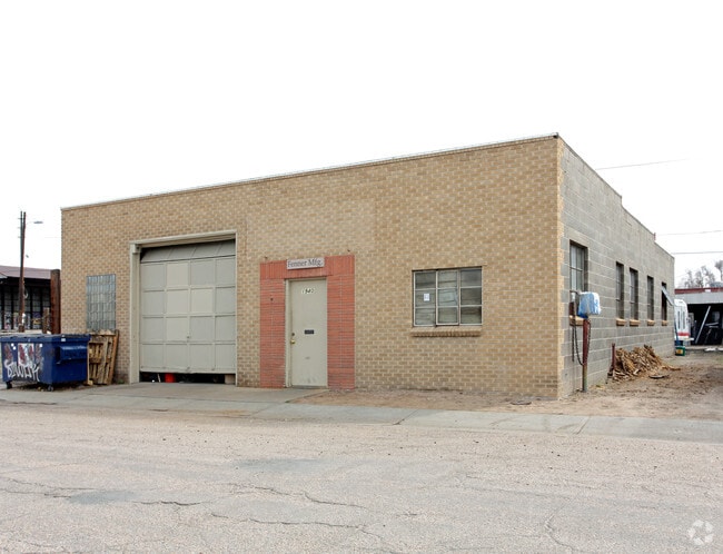
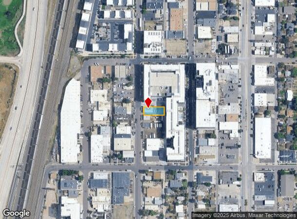
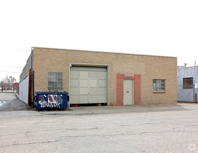
This Property Is For Sale
NEARBY LISTINGS FOR SALE OR LEASE
Property Detail
1940 S Bannock St
Denver-Aurora-Lakewood, CO
Rosedale
5272-02-024
L 11 & 12 BLK 2 ROSEDALE
Industrialgeneral
Denver
AO
Colorado
0800460211J
11,12
2024
0.14 AC
2024
Mid South Central
001403
Denver
2,426 SF
DEMOGRAPHICS near 1940 S Bannock St
1 Mile
3 Mile
5 Mile
2024 Total Population
12,148
163,147
472,926
2029 Population
12,270
164,267
477,409
Pop Growth 2024-2029
+ 1.00%
+ 0.69%
+ 0.95%
Average Age
38
38
39
2024 Total Households
5,551
70,961
219,312
HH Growth 2024-2029
+ 0.88%
+ 0.73%
+ 1.07%
Median Household Inc
$110,126
$80,265
$77,471
Avg Household Size
2.20
2.20
2.10
2024 Avg HH Vehicles
2.00
2.00
2.00
Median Home Value
$754,984
$620,231
$588,506
Median Year Built
1949
1959
1968
Nearby Places
Map Layers
Map Styles
 Street
 Aerial
- Restaurants
- Banks
- Shops
- Fitness
- Groceries
PUBLIC TRANSPORTATION
COMMUTER RAIL
Union Station: LoDo-Coors Field-16th Street Mall (C Line - Denver Regional Transportation District Light Rail (TheRide), E Line - Denver Regional Transportation District Light Rail (TheRide), W Line - Denver Regional Transportation District Light Rail (TheRide))
DRIVE
WALK
Distance
Union Station: LoDo-Coors Field-16th Street Mall (C Line - Denver Regional Transportation District Light Rail (TheRide), E Line - Denver Regional Transportation District Light Rail (TheRide), W Line - Denver Regional Transportation District Light Rail (TheRide))
12 min
6.5 mi
DRIVE
WALK
Distance
12 min
6.5 mi
AIRPORT
Denver International
DRIVE
WALK
Distance
Denver International
42 min
30.6 mi
Nearby Properties
Address
Land Use
TOTAL SIZE
Lot Size
Zoning
Address
Land Use
TOTAL SIZE
Lot Size
Zoning
1,137,044 SF
35.49 AC
CMP-EI
Address
Land Use
TOTAL SIZE
Lot Size
Zoning
117,535 SF
4.76 AC
Address
Land Use
TOTAL SIZE
Lot Size
Zoning
441,643 SF
9.79 AC
H-1-B
Address
Land Use
TOTAL SIZE
Lot Size
Zoning
550,760 SF
13.25 AC
CMP-EI
Address
Land Use
TOTAL SIZE
Lot Size
Zoning
113,932 SF
9.60 AC
I-B
Address
Land Use
TOTAL SIZE
Lot Size
Zoning
543,122 SF
13.43 AC
CMP-EI
Address
Land Use
TOTAL SIZE
Lot Size
Zoning
416,096 SF
5.20 AC
C-MX-20
Address
Land Use
TOTAL SIZE
Lot Size
Zoning
240,545 SF
2.35 AC
C-MX-20
Address
Land Use
TOTAL SIZE
Lot Size
Zoning
505,731 SF
2.46 AC
G-MU-20
Address
Land Use
TOTAL SIZE
Lot Size
Zoning
281,456 SF
36.55 AC
R-5
Address
Land Use
TOTAL SIZE
Lot Size
Zoning
174,244 SF
17.26 AC
E-SU-DX
Address
Land Use
TOTAL SIZE
Lot Size
Zoning
362,988 SF
4.71 AC
T-MU-30
Address
Land Use
TOTAL SIZE
Lot Size
Zoning
68,500 SF
2.14 AC
Address
Land Use
TOTAL SIZE
Lot Size
Zoning
214,192 SF
0.03 AC
Address
Land Use
TOTAL SIZE
Lot Size
Zoning
124,658 SF
2.13 AC
CMP-EI
Address
Land Use
TOTAL SIZE
Lot Size
Zoning
356,004 SF
4.59 AC
C-MX-12
Address
Land Use
TOTAL SIZE
Lot Size
Zoning
341,493 SF
4.22 AC
T-MU-30
Address
Land Use
TOTAL SIZE
Lot Size
Zoning
533,298 SF
3.23 AC
C-MX
Address
Land Use
TOTAL SIZE
Lot Size
Zoning
158,805 SF
3.71 AC
CMP-EI
Address
Land Use
TOTAL SIZE
Lot Size
Zoning
381 SF
66.05 AC
I-B
Address
Land Use
TOTAL SIZE
Lot Size
Zoning
310,910 SF
2.68 AC
C-MX-16
Address
Land Use
TOTAL SIZE
Lot Size
Zoning
205,129 SF
2.94 AC
C-MX-20
Address
Land Use
TOTAL SIZE
Lot Size
Zoning
377,735 SF
1.72 AC
G-RX
Address
Land Use
TOTAL SIZE
Lot Size
Zoning
169,350 SF
19.74 AC
H-1-B
Address
Land Use
TOTAL SIZE
Lot Size
Zoning
67,603 SF
24.89 AC
I-B
Address
Land Use
TOTAL SIZE
Lot Size
Zoning
33,500 SF
53.33 AC
Address
Land Use
TOTAL SIZE
Lot Size
Zoning
288,570 SF
2.57 AC
C-MX-16
Address
Land Use
TOTAL SIZE
Lot Size
Zoning
282,798 SF
3.61 AC
C-MX-5
Address
Land Use
TOTAL SIZE
Lot Size
Zoning
451,335 SF
8.39 AC
B-A-3
Address
Land Use
TOTAL SIZE
Lot Size
Zoning
136,519 SF
1.58 AC
S-MX-8
The World's #1 Commercial Real Estate Marketplace
Connect with us
© 2025 CoStar Group
The information above has been obtained from sources believed reliable. While we do not doubt its accuracy we have not verified it and make no guarantee, warranty or representation about it. It is your responsibility to independently confirm its accuracy and completeness. Any projections, opinions, assumptions, or estimates used are for example only and do not represent the current or future performance of the property. The value of this transaction to you depends on tax and other factors which should be evaluated by your tax, financial, and legal advisors. You and your advisors should conduct a careful, independent investigation of the property to determine to your satisfaction the suitability of the property for your needs.