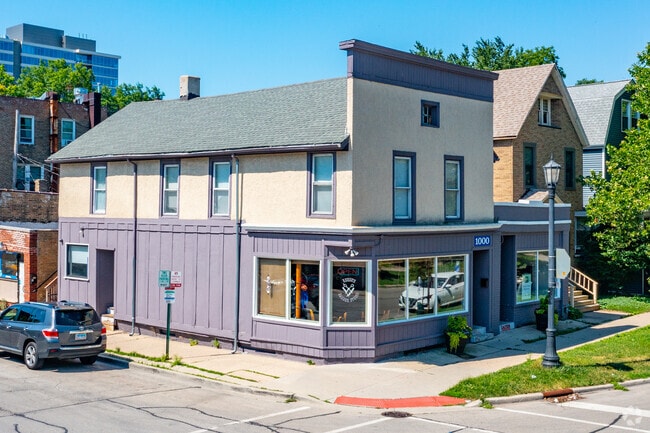
Property Record
1000 Foster St, Evanston, IL 60201

Property Detail
1000 Foster St
Chicago-Naperville-Elgin, IL-IN
J B (HOBBS) SUB OF PT OF THE EH NW NW SEC 18-41-14
11-18-107-020-0000
Cook
Commercialbuilding
Illinois
B and X Area of moderate flood hazard, usually the area between the limits of the 100-year and 500-year floods.
1
2023
0.10 AC
2025
Near North
809300
Chicago
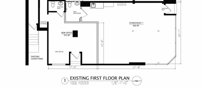
4,762 SF
NEARBY LISTINGS FOR SALE OR LEASE
DEMOGRAPHICS near 1000 Foster St
1 mile
3 mile
5 mile
2025 Total Population
34,240
160,175
402,982
2030 Population
34,796
161,518
406,036
Pop Growth 2025-2030
+ 1.62%
+ 0.84%
+ 0.76%
Average Age
37
41
41
2025 Total Households
13,237
61,474
156,887
HH Growth 2025-2030
+ 1.81%
+ 0.70%
+ 0.59%
Median Household Inc
$73,920
$95,719
$83,754
Avg Household Size
2.00
2.40
2.40
2025 Avg HH Vehicles
1.00
1.00
1.00
Median Home Value
$512,588
$473,004
$417,602
Median Year Built
1962
1952
1952
Nearby Places
Map Layers
Map Styles
 Street
 Aerial
Layers
 Traffic
 Biking
Places
Listings with unknown addresses are not visible on the map
- Restaurants
- Banks
- Shops
- Fitness
- Groceries
PUBLIC TRANSPORTATION
TRANSIT/SUBWAY
Foster Station (Purple Line - Chicago Transit Authority "L" Trains (The "L"))
Drive
Walk
Distance
Foster Station (Purple Line - Chicago Transit Authority "L" Trains (The "L"))
0 min
2 min
0.1 mi
Noyes Station (Purple Line - Chicago Transit Authority "L" Trains (The "L"))
Drive
Walk
Distance
Noyes Station (Purple Line - Chicago Transit Authority "L" Trains (The "L"))
2 min
8 min
0.4 mi
Evanston Davis Street Station (Union Pacific North Line - Northeast Illinois Regional Commuter Railroad (Metra))
Drive
Walk
Distance
Evanston Davis Street Station (Union Pacific North Line - Northeast Illinois Regional Commuter Railroad (Metra))
2 min
8 min
0.4 mi
Davis Station (Purple Line - Chicago Transit Authority "L" Trains (The "L"))
Drive
Walk
Distance
Davis Station (Purple Line - Chicago Transit Authority "L" Trains (The "L"))
1 min
9 min
0.4 mi
Central Station (Purple Line) (Purple Line - Chicago Transit Authority "L" Trains (The "L"))
Drive
Walk
Distance
Central Station (Purple Line) (Purple Line - Chicago Transit Authority "L" Trains (The "L"))
3 min
17 min
0.9 mi
COMMUTER RAIL
Evanston Davis Street Station (Union Pacific North Line - Northeast Illinois Regional Commuter Railroad (Metra))
Drive
Walk
Distance
Evanston Davis Street Station (Union Pacific North Line - Northeast Illinois Regional Commuter Railroad (Metra))
2 min
8 min
0.4 mi
Evanston Central Street Station (Union Pacific North Line - Northeast Illinois Regional Commuter Railroad (Metra))
Drive
Walk
Distance
Evanston Central Street Station (Union Pacific North Line - Northeast Illinois Regional Commuter Railroad (Metra))
3 min
1.3 mi
AIRPORT
Chicago O'Hare International
Drive
Walk
Distance
Chicago O'Hare International
53 min
21.0 mi
Chicago Midway International
Drive
Walk
Distance
Chicago Midway International
44 min
23.1 mi
SALE & LEASE HISTORY
LISTING DATE
SALE/LEASE

Oct 21, 2024
For Lease
Mar 20, 2024
For Lease
Mar 14, 2022
For Lease
Mar 09, 2017
For Lease
Jul 15, 2025
For Lease
Jan 08, 2019
For Lease
Apr 16, 2025
For Lease
Nearby Properties
Address
Land Use
TOTAL SIZE
Lot Size
Zoning
Address
Land Use
TOTAL SIZE
Lot Size
Zoning
180,397 SF
0.78 AC
Address
Land Use
TOTAL SIZE
Lot Size
Zoning
0.63 AC
Address
Land Use
TOTAL SIZE
Lot Size
Zoning
341,698 SF
0.64 AC
Address
Land Use
TOTAL SIZE
Lot Size
Zoning
4,748 SF
0.40 AC
Address
Land Use
TOTAL SIZE
Lot Size
Zoning
303,960 SF
0.98 AC
Address
Land Use
TOTAL SIZE
Lot Size
Zoning
0.84 AC
Address
Land Use
TOTAL SIZE
Lot Size
Zoning
251,409 SF
16.33 AC
Address
Land Use
TOTAL SIZE
Lot Size
Zoning
176,115 SF
1.04 AC
Address
Land Use
TOTAL SIZE
Lot Size
Zoning
218,982 SF
1.97 AC
Address
Land Use
TOTAL SIZE
Lot Size
Zoning
243,781 SF
0.84 AC
Address
Land Use
TOTAL SIZE
Lot Size
Zoning
110,528 SF
3.05 AC
Address
Land Use
TOTAL SIZE
Lot Size
Zoning
0.84 AC
Address
Land Use
TOTAL SIZE
Lot Size
Zoning
Address
Land Use
TOTAL SIZE
Lot Size
Zoning
163,981 SF
4 AC
Address
Land Use
TOTAL SIZE
Lot Size
Zoning
145,548 SF
0.80 AC
Address
Land Use
TOTAL SIZE
Lot Size
Zoning
8,550 SF
0.25 AC
Address
Land Use
TOTAL SIZE
Lot Size
Zoning
1.67 AC
Address
Land Use
TOTAL SIZE
Lot Size
Zoning
2.46 AC
Address
Land Use
TOTAL SIZE
Lot Size
Zoning
208,785 SF
0.61 AC
Address
Land Use
TOTAL SIZE
Lot Size
Zoning
5.65 AC
Address
Land Use
TOTAL SIZE
Lot Size
Zoning
190,350 SF
1.03 AC
Address
Land Use
TOTAL SIZE
Lot Size
Zoning
0.30 AC
Address
Land Use
TOTAL SIZE
Lot Size
Zoning
0.38 AC
Address
Land Use
TOTAL SIZE
Lot Size
Zoning
223,366 SF
0.65 AC
Address
Land Use
TOTAL SIZE
Lot Size
Zoning
117,229 SF
Address
Land Use
TOTAL SIZE
Lot Size
Zoning
1.62 AC
Address
Land Use
TOTAL SIZE
Lot Size
Zoning
119,468 SF
0.57 AC
Address
Land Use
TOTAL SIZE
Lot Size
Zoning
47,283 SF
1.18 AC
Address
Land Use
TOTAL SIZE
Lot Size
Zoning
61,840 SF
0.28 AC
Address
Land Use
TOTAL SIZE
Lot Size
Zoning
122,873 SF
0.57 AC
The World's #1 Commercial Real Estate Marketplace
Connect with us
© 2026 CoStar Group
The information above has been obtained from sources believed reliable. While we do not doubt its accuracy we have not verified it and make no guarantee, warranty or representation about it. It is your responsibility to independently confirm its accuracy and completeness. Any projections, opinions, assumptions, or estimates used are for example only and do not represent the current or future performance of the property. The value of this transaction to you depends on tax and other factors which should be evaluated by your tax, financial, and legal advisors. You and your advisors should conduct a careful, independent investigation of the property to determine to your satisfaction the suitability of the property for your needs.