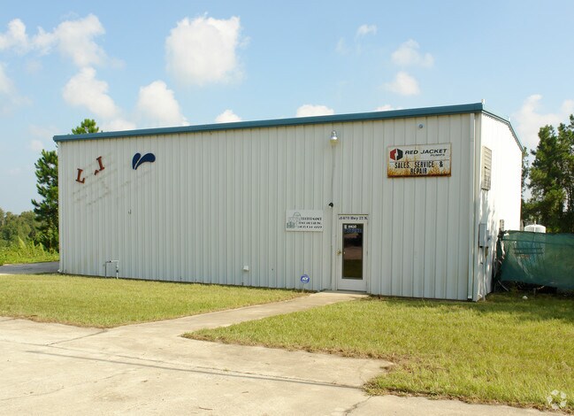
Property Record
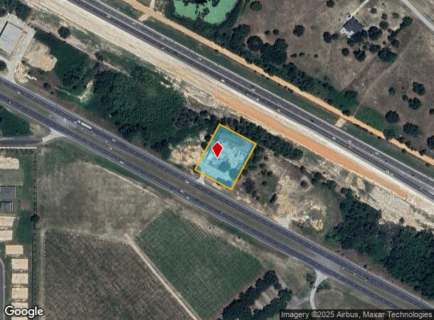
19430 Us Highway 27, Clermont, FL 34715

NEARBY LISTINGS FOR SALE OR LEASE
Property Detail
19430 Us Highway 27
Orlando-Kissimmee-Sanford, FL
Acreage & Unrec
25-21-25-0003-000-02800
FROM SW COR OF NW 1/4 RUN N 89-55-10 E ALONG S LINE OF SAID NW 1/4 TO NELY R/W OF US HWY 27 S 61-59-30 E ALONG SAID R/W 270.94 FT TO POB RUN N 28-0-30 E 249.44 FT TO SWLY R/W OF TURNPIKE S 62-0-32 E ALONG R/W 200 FT S 28-0-30 W 249.50 FT TO NELY R/W
Autorepair
Lake
X
Florida
12069C0495E
28
2024
1.15 AC
2026
Lake County
031208
Orlando
1,500 SF
DEMOGRAPHICS near 19430 Us Highway 27
1 Mile
3 Mile
5 Mile
2024 Total Population
889
14,158
42,301
2029 Population
1,034
16,716
50,043
Pop Growth 2024-2029
+ 16.31%
+ 18.07%
+ 18.30%
Average Age
54
45
41
2024 Total Households
334
5,139
14,945
HH Growth 2024-2029
+ 16.77%
+ 17.86%
+ 18.03%
Median Household Inc
$93,933
$88,035
$83,061
Avg Household Size
2.10
2.50
2.80
2024 Avg HH Vehicles
2.00
2.00
2.00
Median Home Value
$349,127
$317,303
$324,535
Median Year Built
2010
2010
2008
Nearby Places
Map Layers
Map Styles
 Street
 Aerial
- Restaurants
- Banks
- Shops
- Fitness
- Groceries
PUBLIC TRANSPORTATION
AIRPORT
Orlando International
DRIVE
WALK
Distance
Orlando International
50 min
38.2 mi
Orlando Sanford International
DRIVE
WALK
Distance
Orlando Sanford International
70 min
49.3 mi
Freight Ports
Port of Tampa Bay
DRIVE
WALK
Distance
Port of Tampa Bay
105 min
81.9 mi
Nearby Properties
Address
Land Use
TOTAL SIZE
Lot Size
Zoning
Address
Land Use
TOTAL SIZE
Lot Size
Zoning
980,381 SF
89.73 AC
A
Address
Land Use
TOTAL SIZE
Lot Size
Zoning
570,180 SF
45.30 AC
PUD
Address
Land Use
TOTAL SIZE
Lot Size
Zoning
43,769 SF
287.86 AC
C1
Address
Land Use
TOTAL SIZE
Lot Size
Zoning
83.86 AC
Address
Land Use
TOTAL SIZE
Lot Size
Zoning
125,732 SF
20.19 AC
PUD
Address
Land Use
TOTAL SIZE
Lot Size
Zoning
128,174 SF
9.88 AC
B1
Address
Land Use
TOTAL SIZE
Lot Size
Zoning
80,546 SF
6.75 AC
B1
Address
Land Use
TOTAL SIZE
Lot Size
Zoning
116,737 SF
71.77 AC
MP
Address
Land Use
TOTAL SIZE
Lot Size
Zoning
123,387 SF
47.51 AC
R3
Address
Land Use
TOTAL SIZE
Lot Size
Zoning
56.54 AC
PUD
Address
Land Use
TOTAL SIZE
Lot Size
Zoning
46,302 SF
24.06 AC
HM
Address
Land Use
TOTAL SIZE
Lot Size
Zoning
67,562 SF
5.01 AC
Address
Land Use
TOTAL SIZE
Lot Size
Zoning
65,330 SF
3.89 AC
Address
Land Use
TOTAL SIZE
Lot Size
Zoning
71.86 AC
Address
Land Use
TOTAL SIZE
Lot Size
Zoning
64,000 SF
5.31 AC
Address
Land Use
TOTAL SIZE
Lot Size
Zoning
8,030 SF
46.70 AC
C2
Address
Land Use
TOTAL SIZE
Lot Size
Zoning
146,124 SF
10.41 AC
C1
Address
Land Use
TOTAL SIZE
Lot Size
Zoning
51,272 SF
4.91 AC
C2
Address
Land Use
TOTAL SIZE
Lot Size
Zoning
40,348 SF
4.92 AC
Address
Land Use
TOTAL SIZE
Lot Size
Zoning
27,332 SF
15.48 AC
C1
Address
Land Use
TOTAL SIZE
Lot Size
Zoning
50,011 SF
4.35 AC
C1
Address
Land Use
TOTAL SIZE
Lot Size
Zoning
23,504 SF
11.97 AC
CFD
Address
Land Use
TOTAL SIZE
Lot Size
Zoning
14,729 SF
1.95 AC
B1
Address
Land Use
TOTAL SIZE
Lot Size
Zoning
40.73 AC
R1
Address
Land Use
TOTAL SIZE
Lot Size
Zoning
57,187 SF
170.79 AC
HM
Address
Land Use
TOTAL SIZE
Lot Size
Zoning
3.91 AC
Address
Land Use
TOTAL SIZE
Lot Size
Zoning
5,245 SF
8.28 AC
R1
Address
Land Use
TOTAL SIZE
Lot Size
Zoning
13,014 SF
2.09 AC
B1
Address
Land Use
TOTAL SIZE
Lot Size
Zoning
11,364 SF
2.05 AC
B1
Address
Land Use
TOTAL SIZE
Lot Size
Zoning
34.20 AC
A
The World's #1 Commercial Real Estate Marketplace
Connect with us
© 2025 CoStar Group
The information above has been obtained from sources believed reliable. While we do not doubt its accuracy we have not verified it and make no guarantee, warranty or representation about it. It is your responsibility to independently confirm its accuracy and completeness. Any projections, opinions, assumptions, or estimates used are for example only and do not represent the current or future performance of the property. The value of this transaction to you depends on tax and other factors which should be evaluated by your tax, financial, and legal advisors. You and your advisors should conduct a careful, independent investigation of the property to determine to your satisfaction the suitability of the property for your needs.