Property Record
195 W State Road 198, Salem, UT 84653

NEARBY LISTINGS FOR SALE OR LEASE
-
-
View all Salem listings for sale on LoopNet.com
Property Detail
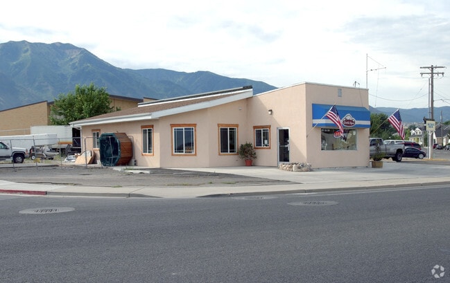
195 W State Road 198
Salt Lake City
Plat A Salem City Survey Of Building Lot
Provo-Orem, UT
COM NW COR LOT 3, BLK 30, PLAT A, SALEM CITY SUR; E 153.5 FT; S 110 FT; W 153.5 FT; N 110 FT TO BEG.
09-030-0005
Utah
Restaurantdrivein
Utah
2024
3
2025
0.39 AC
010407
Utah County
2,125 SF
DEMOGRAPHICS near 195 W State Road 198
1 Mile
3 Mile
5 Mile
2024 Total Population
5,804
26,825
84,786
2029 Population
6,828
31,652
99,289
Pop Growth 2024-2029
+ 17.64%
+ 17.99%
+ 17.11%
Average Age
35
34
33
2024 Total Households
1,631
7,269
23,213
HH Growth 2024-2029
+ 17.96%
+ 18.34%
+ 17.44%
Median Household Inc
$99,581
$100,259
$92,333
Avg Household Size
3.60
3.70
3.60
2024 Avg HH Vehicles
3.00
3.00
3.00
Median Home Value
$503,285
$519,569
$431,960
Median Year Built
1998
2000
1999
Nearby Places
Map Layers
Map Styles
 Street
 Aerial
- Restaurants
- Banks
- Shops
- Fitness
- Groceries
PUBLIC TRANSPORTATION
AIRPORT
Provo Municipal
DRIVE
WALK
Distance
Provo Municipal
23 min
14.8 mi
Freight Ports
Port of Stockton
DRIVE
WALK
Distance
Port of Stockton
772 min
751.3 mi
SALE & LEASE HISTORY
LISTING DATE
SALE/LEASE

Mar 13, 2017
For Sale
Aug 03, 2018
For Sale
Nearby Properties
Address
Land Use
TOTAL SIZE
Lot Size
Zoning
Address
Land Use
TOTAL SIZE
Lot Size
Zoning
169,938 SF
8.96 AC
Address
Land Use
TOTAL SIZE
Lot Size
Zoning
92,323 SF
8.96 AC
Address
Land Use
TOTAL SIZE
Lot Size
Zoning
64,375 SF
25.19 AC
Address
Land Use
TOTAL SIZE
Lot Size
Zoning
729,831 SF
66.60 AC
RA5
Address
Land Use
TOTAL SIZE
Lot Size
Zoning
138,990 SF
6.57 AC
Address
Land Use
TOTAL SIZE
Lot Size
Zoning
122,808 SF
6.61 AC
Address
Land Use
TOTAL SIZE
Lot Size
Zoning
99,114 SF
3.67 AC
Address
Land Use
TOTAL SIZE
Lot Size
Zoning
90,004 SF
5.64 AC
Address
Land Use
TOTAL SIZE
Lot Size
Zoning
43,845 SF
4.95 AC
Address
Land Use
TOTAL SIZE
Lot Size
Zoning
125,459 SF
10 AC
Address
Land Use
TOTAL SIZE
Lot Size
Zoning
89,829 SF
5.04 AC
Address
Land Use
TOTAL SIZE
Lot Size
Zoning
17.20 AC
Address
Land Use
TOTAL SIZE
Lot Size
Zoning
221,351 SF
13.25 AC
Address
Land Use
TOTAL SIZE
Lot Size
Zoning
39,168 SF
3.54 AC
Address
Land Use
TOTAL SIZE
Lot Size
Zoning
33.17 AC
Address
Land Use
TOTAL SIZE
Lot Size
Zoning
36,173 SF
3.93 AC
RA5
Address
Land Use
TOTAL SIZE
Lot Size
Zoning
12,930 SF
5.54 AC
Address
Land Use
TOTAL SIZE
Lot Size
Zoning
21,396 SF
1.68 AC
Address
Land Use
TOTAL SIZE
Lot Size
Zoning
14,437 SF
1.10 AC
Address
Land Use
TOTAL SIZE
Lot Size
Zoning
87,029 SF
4.18 AC
Address
Land Use
TOTAL SIZE
Lot Size
Zoning
19,203 SF
0.82 AC
Address
Land Use
TOTAL SIZE
Lot Size
Zoning
35,637 SF
1.94 AC
Address
Land Use
TOTAL SIZE
Lot Size
Zoning
3,671 SF
11.44 AC
Address
Land Use
TOTAL SIZE
Lot Size
Zoning
5,885 SF
3.05 AC
Address
Land Use
TOTAL SIZE
Lot Size
Zoning
16,900 SF
15.54 AC
Address
Land Use
TOTAL SIZE
Lot Size
Zoning
3,982 SF
2.67 AC
Address
Land Use
TOTAL SIZE
Lot Size
Zoning
17,152 SF
0.75 AC
Address
Land Use
TOTAL SIZE
Lot Size
Zoning
15,025 SF
1 AC
Address
Land Use
TOTAL SIZE
Lot Size
Zoning
8.25 AC
The World's #1 Commercial Real Estate Marketplace
Connect with us
© 2025 CoStar Group
The information above has been obtained from sources believed reliable. While we do not doubt its accuracy we have not verified it and make no guarantee, warranty or representation about it. It is your responsibility to independently confirm its accuracy and completeness. Any projections, opinions, assumptions, or estimates used are for example only and do not represent the current or future performance of the property. The value of this transaction to you depends on tax and other factors which should be evaluated by your tax, financial, and legal advisors. You and your advisors should conduct a careful, independent investigation of the property to determine to your satisfaction the suitability of the property for your needs.