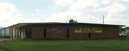
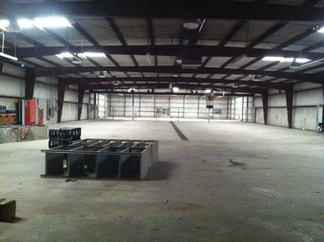
Property Record
195 W Vaughn Rd, Cleburne, TX 76033
NEARBY LISTINGS FOR SALE OR LEASE
Property Detail
195 W Vaughn Rd
Dallas-Fort Worth-Arlington, TX
4P Metals Addition
126-2259-01020
LOT 2 BLK 1 4P METALS ADDITION
Commercialnec
Johnson
X
Texas
48251C0160J
2
2024
4.19 AC
2025
Johnson County
130302
Dallas/Ft Worth
57,408 SF
DEMOGRAPHICS near 195 W Vaughn Rd
1 mile
3 mile
5 mile
2024 Total Population
603
13,572
51,584
2029 Population
710
16,271
61,779
Pop Growth 2024-2029
+ 17.74%
+ 19.89%
+ 19.76%
Average Age
41
38
38
2024 Total Households
224
4,727
18,191
HH Growth 2024-2029
+ 18.30%
+ 20.41%
+ 20.24%
Median Household Inc
$80,000
$51,709
$59,730
Avg Household Size
2.60
2.60
2.70
2024 Avg HH Vehicles
2.00
2.00
2.00
Median Home Value
$265,624
$149,236
$155,111
Median Year Built
1984
1985
1984
Nearby Places
Map Layers
Map Styles
 Street
 Aerial
Transit
 Traffic
 Biking
Places
Listings with unknown addresses are not visible on the map
- Restaurants
- Banks
- Shops
- Fitness
- Groceries
PUBLIC TRANSPORTATION
COMMUTER RAIL
Cleburne Amtrak Station (Texas Eagle - Amtrak)
Drive
Walk
Distance
Cleburne Amtrak Station (Texas Eagle - Amtrak)
9 min
4.6 mi
Freight Ports
Port of Shreveport
Drive
Walk
Distance
Port of Shreveport
264 min
241.4 mi
SALE & LEASE HISTORY
LISTING DATE
SALE/LEASE

Sep 25, 2016
For Lease
Nearby Properties
Address
Land Use
TOTAL SIZE
Lot Size
Zoning
Address
Land Use
TOTAL SIZE
Lot Size
Zoning
1 SF
0.21 AC
Address
Land Use
TOTAL SIZE
Lot Size
Zoning
1.14 AC
Address
Land Use
TOTAL SIZE
Lot Size
Zoning
1.14 AC
Address
Land Use
TOTAL SIZE
Lot Size
Zoning
910,071 SF
0.21 AC
Address
Land Use
TOTAL SIZE
Lot Size
Zoning
1.14 AC
Address
Land Use
TOTAL SIZE
Lot Size
Zoning
11,176 SF
0.08 AC
Address
Land Use
TOTAL SIZE
Lot Size
Zoning
16.56 AC
Address
Land Use
TOTAL SIZE
Lot Size
Zoning
11.04 AC
Address
Land Use
TOTAL SIZE
Lot Size
Zoning
26,932 SF
17.62 AC
Address
Land Use
TOTAL SIZE
Lot Size
Zoning
271,345 SF
0.21 AC
Address
Land Use
TOTAL SIZE
Lot Size
Zoning
69,592 SF
29.56 AC
Address
Land Use
TOTAL SIZE
Lot Size
Zoning
24.44 AC
Address
Land Use
TOTAL SIZE
Lot Size
Zoning
612,261 SF
0.21 AC
Address
Land Use
TOTAL SIZE
Lot Size
Zoning
668,640 SF
0.08 AC
Address
Land Use
TOTAL SIZE
Lot Size
Zoning
221,203 SF
15.60 AC
Address
Land Use
TOTAL SIZE
Lot Size
Zoning
394,274 SF
Address
Land Use
TOTAL SIZE
Lot Size
Zoning
1 SF
35.23 AC
Address
Land Use
TOTAL SIZE
Lot Size
Zoning
70,258 SF
5.50 AC
Address
Land Use
TOTAL SIZE
Lot Size
Zoning
46,839 SF
15.51 AC
Address
Land Use
TOTAL SIZE
Lot Size
Zoning
Address
Land Use
TOTAL SIZE
Lot Size
Zoning
Address
Land Use
TOTAL SIZE
Lot Size
Zoning
14.40 AC
Address
Land Use
TOTAL SIZE
Lot Size
Zoning
143,327 SF
20 AC
Address
Land Use
TOTAL SIZE
Lot Size
Zoning
129,408 SF
16.72 AC
Address
Land Use
TOTAL SIZE
Lot Size
Zoning
42,182 SF
11.19 AC
Address
Land Use
TOTAL SIZE
Lot Size
Zoning
82,669 SF
11.50 AC
Address
Land Use
TOTAL SIZE
Lot Size
Zoning
43,070 SF
7.57 AC
Address
Land Use
TOTAL SIZE
Lot Size
Zoning
8,822 SF
0.42 AC
Address
Land Use
TOTAL SIZE
Lot Size
Zoning
109,045 SF
12.09 AC
Address
Land Use
TOTAL SIZE
Lot Size
Zoning
74,607 SF
12.64 AC
The World's #1 Commercial Real Estate Marketplace
Connect with us
© 2026 CoStar Group
The information above has been obtained from sources believed reliable. While we do not doubt its accuracy we have not verified it and make no guarantee, warranty or representation about it. It is your responsibility to independently confirm its accuracy and completeness. Any projections, opinions, assumptions, or estimates used are for example only and do not represent the current or future performance of the property. The value of this transaction to you depends on tax and other factors which should be evaluated by your tax, financial, and legal advisors. You and your advisors should conduct a careful, independent investigation of the property to determine to your satisfaction the suitability of the property for your needs.