Property Record
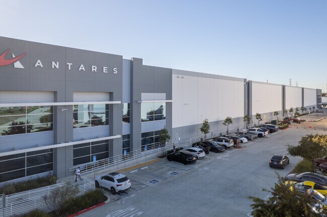
19501 Prairie Ave, Torrance, CA 90503


Current Lease Availabilities
NEARBY LISTINGS FOR SALE OR LEASE
Property Detail
19501 Prairie Ave
Los Angeles-Long Beach-Glendale, CA
PM 418-15-23 LOT 1
7352-001-041
Los Angeles
Warehouse
California
2024
1
2025
15.06 AC
980005
Torrance
321,011 SF
Los Angeles
DEMOGRAPHICS near 19501 Prairie Ave
1 Mile
3 Mile
5 Mile
2024 Total Population
19,105
244,698
590,286
2029 Population
18,989
242,752
586,944
Pop Growth 2024-2029
(0.61%)
(0.80%)
(0.57%)
Average Age
41
42
42
2024 Total Households
7,233
91,235
212,613
HH Growth 2024-2029
(0.80%)
(1.00%)
(0.73%)
Median Household Inc
$98,383
$116,177
$105,846
Avg Household Size
2.60
2.60
2.70
2024 Avg HH Vehicles
2.00
2.00
2.00
Median Home Value
$994,905
$1,015,878
$946,566
Median Year Built
1964
1965
1965
Nearby Places
Map Layers
Map Styles
 Street
 Aerial
- Restaurants
- Banks
- Shops
- Fitness
- Groceries
PUBLIC TRANSPORTATION
AIRPORT
Los Angeles International
DRIVE
WALK
Distance
Los Angeles International
16 min
9.6 mi
Long Beach (Daugherty Field)
DRIVE
WALK
Distance
Long Beach (Daugherty Field)
19 min
12.4 mi
Bob Hope
DRIVE
WALK
Distance
Bob Hope
45 min
33.2 mi
Freight Ports
Port of Los Angeles
DRIVE
WALK
Distance
Port of Los Angeles
26 min
15.5 mi
Nearby Properties
Address
Land Use
TOTAL SIZE
Lot Size
Zoning
Address
Land Use
TOTAL SIZE
Lot Size
Zoning
767,582 SF
13.62 AC
TOHHM
Address
Land Use
TOTAL SIZE
Lot Size
Zoning
997,143 SF
98.35 AC
TOMI-BP
Address
Land Use
TOTAL SIZE
Lot Size
Zoning
267,305 SF
1.59 AC
TOHC-CTR
Address
Land Use
TOTAL SIZE
Lot Size
Zoning
205,797 SF
4.10 AC
HBR3*
Address
Land Use
TOTAL SIZE
Lot Size
Zoning
10,152 SF
140.14 AC
TOMI-HVY
Address
Land Use
TOTAL SIZE
Lot Size
Zoning
422,640 SF
LAM3
Address
Land Use
TOTAL SIZE
Lot Size
Zoning
267,131 SF
12.10 AC
TOHHM
Address
Land Use
TOTAL SIZE
Lot Size
Zoning
718,086 SF
41.24 AC
RBI-1A
Address
Land Use
TOTAL SIZE
Lot Size
Zoning
848,217 SF
36.09 AC
RBI-1A
Address
Land Use
TOTAL SIZE
Lot Size
Zoning
297,420 SF
6.65 AC
TOHC-CTR
Address
Land Use
TOTAL SIZE
Lot Size
Zoning
173,186 SF
2.07 AC
HBR3*
Address
Land Use
TOTAL SIZE
Lot Size
Zoning
604,106 SF
42.72 AC
TOMI-HVY
Address
Land Use
TOTAL SIZE
Lot Size
Zoning
506,189 SF
20.33 AC
LAM2
Address
Land Use
TOTAL SIZE
Lot Size
Zoning
1,504,661 SF
RBCR
Address
Land Use
TOTAL SIZE
Lot Size
Zoning
3,585,714 SF
67.35 AC
LAM3
Address
Land Use
TOTAL SIZE
Lot Size
Zoning
409,522 SF
11.41 AC
LAM3
Address
Land Use
TOTAL SIZE
Lot Size
Zoning
202,924 SF
6.15 AC
TOHC-CTR
Address
Land Use
TOTAL SIZE
Lot Size
Zoning
184,300 SF
8.14 AC
LAM3
Address
Land Use
TOTAL SIZE
Lot Size
Zoning
257,723 SF
4.06 AC
TOCC-GEN
Address
Land Use
TOTAL SIZE
Lot Size
Zoning
405,352 SF
7.70 AC
TOHC-CTR
Address
Land Use
TOTAL SIZE
Lot Size
Zoning
239,992 SF
4.72 AC
RBI-1B
Address
Land Use
TOTAL SIZE
Lot Size
Zoning
103,228 SF
1.19 AC
TORR-HI
Address
Land Use
TOTAL SIZE
Lot Size
Zoning
260,766 SF
10.70 AC
LAM3
Address
Land Use
TOTAL SIZE
Lot Size
Zoning
502,236 SF
11.58 AC
TOMI-LT
Address
Land Use
TOTAL SIZE
Lot Size
Zoning
75,054 SF
1.17 AC
RBRMD
The World's #1 Commercial Real Estate Marketplace
Connect with us
© 2025 CoStar Group
The information above has been obtained from sources believed reliable. While we do not doubt its accuracy we have not verified it and make no guarantee, warranty or representation about it. It is your responsibility to independently confirm its accuracy and completeness. Any projections, opinions, assumptions, or estimates used are for example only and do not represent the current or future performance of the property. The value of this transaction to you depends on tax and other factors which should be evaluated by your tax, financial, and legal advisors. You and your advisors should conduct a careful, independent investigation of the property to determine to your satisfaction the suitability of the property for your needs.