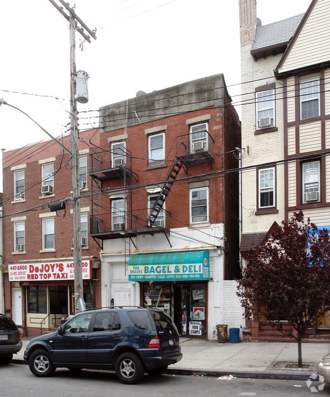
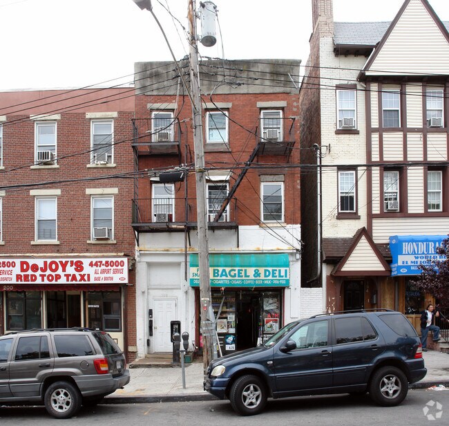
Property Record
196 Bay St, Staten Island, NY 10301
NEARBY LISTINGS FOR SALE OR LEASE
Property Detail
196 Bay St
00498-0061
Staten Island
Commercialofficeresidentialmixeduse
New York
X
61
3604970189F
0.06 AC
2024
Staten Island
2025
Long Island (New York)
002100
New York-Jersey City-White Plains, NY-NJ
2,700 SF
DEMOGRAPHICS near 196 Bay St
1 Mile
3 Mile
5 Mile
2024 Total Population
26,963
226,096
781,834
2029 Population
26,747
220,212
739,855
Pop Growth 2024-2029
(0.80%)
(2.60%)
(5.37%)
Average Age
39
40
39
2024 Total Households
10,057
84,061
268,651
HH Growth 2024-2029
(0.56%)
(2.92%)
(5.54%)
Median Household Inc
$60,383
$72,373
$70,238
Avg Household Size
2.50
2.60
2.80
2024 Avg HH Vehicles
1.00
1.00
1.00
Median Home Value
$541,836
$561,094
$653,748
Median Year Built
1949
1955
1951
Nearby Places
- Restaurants
- Banks
- Shops
- Fitness
- Groceries
PUBLIC TRANSPORTATION
TRANSIT/SUBWAY
Tompkinsville (Staten Island Railway - New York MTA Subway (The Subway))
DRIVE
WALK
Distance
Tompkinsville (Staten Island Railway - New York MTA Subway (The Subway))
1 min
3 min
0.1 mi
St George (Staten Island Railway - New York MTA Subway (The Subway))
DRIVE
WALK
Distance
St George (Staten Island Railway - New York MTA Subway (The Subway))
3 min
11 min
0.6 mi
Stapleton (Staten Island Railway - New York MTA Subway (The Subway))
DRIVE
WALK
Distance
Stapleton (Staten Island Railway - New York MTA Subway (The Subway))
3 min
14 min
0.7 mi
COMMUTER RAIL
Tompkinsville (Staten Island Railway - New York MTA Subway (The Subway))
DRIVE
WALK
Distance
Tompkinsville (Staten Island Railway - New York MTA Subway (The Subway))
1 min
3 min
0.1 mi
St George (Staten Island Railway - New York MTA Subway (The Subway))
DRIVE
WALK
Distance
St George (Staten Island Railway - New York MTA Subway (The Subway))
3 min
11 min
0.6 mi
AIRPORT
Newark Liberty International
DRIVE
WALK
Distance
Newark Liberty International
29 min
15.0 mi
LaGuardia
DRIVE
WALK
Distance
LaGuardia
42 min
22.6 mi
John F Kennedy International
DRIVE
WALK
Distance
John F Kennedy International
44 min
24.9 mi
Freight Ports
New York Container Terminal
DRIVE
WALK
Distance
New York Container Terminal
17 min
8.2 mi
Nearby Properties
Address
Land Use
TOTAL SIZE
Lot Size
Zoning
Address
Land Use
TOTAL SIZE
Lot Size
Zoning
Address
Land Use
TOTAL SIZE
Lot Size
Zoning
22.49 AC
HC
Address
Land Use
TOTAL SIZE
Lot Size
Zoning
460,000 SF
3.21 AC
R6
Address
Land Use
TOTAL SIZE
Lot Size
Zoning
30.92 AC
Address
Land Use
TOTAL SIZE
Lot Size
Zoning
3.27 AC
Address
Land Use
TOTAL SIZE
Lot Size
Zoning
17.60 AC
Address
Land Use
TOTAL SIZE
Lot Size
Zoning
397,354 SF
0.61 AC
C5-2
Address
Land Use
TOTAL SIZE
Lot Size
Zoning
28.47 AC
I-H
Address
Land Use
TOTAL SIZE
Lot Size
Zoning
114.66 AC
BMHO
Address
Land Use
TOTAL SIZE
Lot Size
Zoning
115.33 AC
IH
Address
Land Use
TOTAL SIZE
Lot Size
Zoning
74.35 AC
TDD
Address
Land Use
TOTAL SIZE
Lot Size
Zoning
Address
Land Use
TOTAL SIZE
Lot Size
Zoning
1,502 SF
0.69 AC
C-1
Address
Land Use
TOTAL SIZE
Lot Size
Zoning
Address
Land Use
TOTAL SIZE
Lot Size
Zoning
236,591 SF
207.66 AC
R3-2
Address
Land Use
TOTAL SIZE
Lot Size
Zoning
73.86 AC
IH
Address
Land Use
TOTAL SIZE
Lot Size
Zoning
2.77 AC
Address
Land Use
TOTAL SIZE
Lot Size
Zoning
538,240 SF
12.08 AC
R2
Address
Land Use
TOTAL SIZE
Lot Size
Zoning
5,359,400 SF
59.07 AC
M2-1
Address
Land Use
TOTAL SIZE
Lot Size
Zoning
25.67 AC
Address
Land Use
TOTAL SIZE
Lot Size
Zoning
286,000 SF
12.63 AC
PARK
Address
Land Use
TOTAL SIZE
Lot Size
Zoning
521,405 SF
52.79 AC
R3-1
Address
Land Use
TOTAL SIZE
Lot Size
Zoning
816 SF
1.57 AC
Address
Land Use
TOTAL SIZE
Lot Size
Zoning
Address
Land Use
TOTAL SIZE
Lot Size
Zoning
111,000 SF
186.03 AC
PARK
Address
Land Use
TOTAL SIZE
Lot Size
Zoning
Address
Land Use
TOTAL SIZE
Lot Size
Zoning
48.68 AC
IH
Address
Land Use
TOTAL SIZE
Lot Size
Zoning
Address
Land Use
TOTAL SIZE
Lot Size
Zoning
Address
Land Use
TOTAL SIZE
Lot Size
Zoning
The World's #1 Commercial Real Estate Marketplace
Connect with us
© 2025 CoStar Group
The information above has been obtained from sources believed reliable. While we do not doubt its accuracy we have not verified it and make no guarantee, warranty or representation about it. It is your responsibility to independently confirm its accuracy and completeness. Any projections, opinions, assumptions, or estimates used are for example only and do not represent the current or future performance of the property. The value of this transaction to you depends on tax and other factors which should be evaluated by your tax, financial, and legal advisors. You and your advisors should conduct a careful, independent investigation of the property to determine to your satisfaction the suitability of the property for your needs.