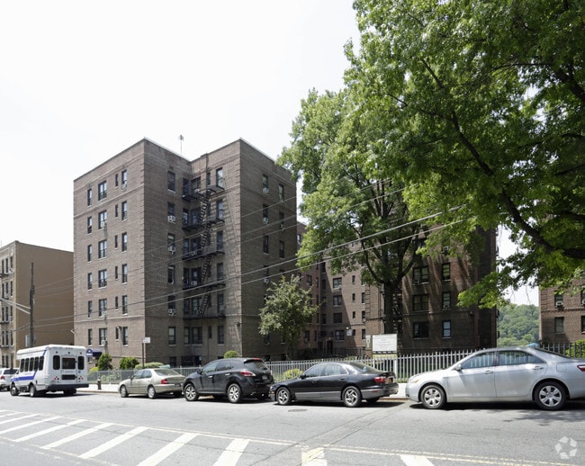
Property Record
1981 Sedgwick Ave, Bronx, NY 10453

NEARBY LISTINGS FOR SALE OR LEASE
Property Detail
1981 Sedgwick Ave
03230-0016
Bronx
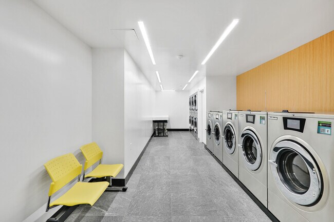
Apartment
New York
X
16
3604970081F
1.66 AC
2024
University Heights
2025
Westchester/So Connecticut
024700
New York-Jersey City-White Plains, NY-NJ
185,000 SF
DEMOGRAPHICS near 1981 Sedgwick Ave
1 mile
3 mile
5 mile
2024 Total Population
238,234
1,174,090
2,049,932
2029 Population
222,431
1,099,349
1,909,170
Pop Growth 2024-2029
(6.63%)
(6.37%)
(6.87%)
Average Age
38
38
39
2024 Total Households
83,810
426,628
760,503
HH Growth 2024-2029
(7.20%)
(6.88%)
(7.31%)
Median Household Inc
$42,805
$42,977
$47,748
Avg Household Size
2.70
2.60
2.50
2024 Avg HH Vehicles
.00
.00
1.00
Median Home Value
$374,908
$464,673
$546,253
Median Year Built
1947
1949
1952
Nearby Places
Map Layers
Map Styles
 Street
 Aerial
Transit
 Traffic
 Biking
Places
Listings with unknown addresses are not visible on the map
- Restaurants
- Banks
- Shops
- Fitness
- Groceries
PUBLIC TRANSPORTATION
TRANSIT/SUBWAY
Morris Heights Station (Hudson Line - Metro-North Commuter Railroad Company (Metro-North))
Drive
Walk
Distance
Morris Heights Station (Hudson Line - Metro-North Commuter Railroad Company (Metro-North))
2 min
9 min
0.5 mi
Burnside Avenue (4 - New York MTA Subway (The Subway))
Drive
Walk
Distance
Burnside Avenue (4 - New York MTA Subway (The Subway))
2 min
15 min
0.8 mi
University Heights Station (Hudson Line - Metro-North Commuter Railroad Company (Metro-North))
Drive
Walk
Distance
University Heights Station (Hudson Line - Metro-North Commuter Railroad Company (Metro-North))
3 min
15 min
0.8 mi
207 Street (1 - New York MTA Subway (The Subway))
Drive
Walk
Distance
207 Street (1 - New York MTA Subway (The Subway))
4 min
20 min
1.0 mi
COMMUTER RAIL
Morris Heights Station (Hudson Line - Metro-North Commuter Railroad Company (Metro-North))
Drive
Walk
Distance
Morris Heights Station (Hudson Line - Metro-North Commuter Railroad Company (Metro-North))
4 min
9 min
0.5 mi
University Heights Station (Hudson Line - Metro-North Commuter Railroad Company (Metro-North))
Drive
Walk
Distance
University Heights Station (Hudson Line - Metro-North Commuter Railroad Company (Metro-North))
3 min
13 min
0.7 mi
AIRPORT
LaGuardia
Drive
Walk
Distance
LaGuardia
18 min
9.7 mi
John F Kennedy International
Drive
Walk
Distance
John F Kennedy International
31 min
20.6 mi
Newark Liberty International
Drive
Walk
Distance
Newark Liberty International
28 min
22.2 mi
Freight Ports
NY - Red Hook Container Terminal
Drive
Walk
Distance
NY - Red Hook Container Terminal
31 min
17.9 mi
SALE & LEASE HISTORY
LISTING DATE
SALE/LEASE

Dec 15, 2017
For Lease
Nearby Properties
Address
Land Use
TOTAL SIZE
Lot Size
Zoning
Address
Land Use
TOTAL SIZE
Lot Size
Zoning
3,693,539 SF
8.37 AC
R8
Address
Land Use
TOTAL SIZE
Lot Size
Zoning
1,299,700 SF
29.82 AC
R6
Address
Land Use
TOTAL SIZE
Lot Size
Zoning
1,743,584 SF
77.87 AC
R6
Address
Land Use
TOTAL SIZE
Lot Size
Zoning
24.08 AC
B2-A
Address
Land Use
TOTAL SIZE
Lot Size
Zoning
4.87 AC
R11
Address
Land Use
TOTAL SIZE
Lot Size
Zoning
1,651,267 SF
1.23 AC
R8
Address
Land Use
TOTAL SIZE
Lot Size
Zoning
Address
Land Use
TOTAL SIZE
Lot Size
Zoning
72 AC
P1
Address
Land Use
TOTAL SIZE
Lot Size
Zoning
2.61 AC
D5
Address
Land Use
TOTAL SIZE
Lot Size
Zoning
481,172 SF
205.58 AC
PARK
Address
Land Use
TOTAL SIZE
Lot Size
Zoning
895,256 SF
8.32 AC
R7-1
Address
Land Use
TOTAL SIZE
Lot Size
Zoning
0.36 AC
R8
Address
Land Use
TOTAL SIZE
Lot Size
Zoning
891,040 SF
5.63 AC
R8
Address
Land Use
TOTAL SIZE
Lot Size
Zoning
1,311,800 SF
9.89 AC
C4-4
Address
Land Use
TOTAL SIZE
Lot Size
Zoning
23.12 AC
PARK
Address
Land Use
TOTAL SIZE
Lot Size
Zoning
1,237,424 SF
21.25 AC
R6
Address
Land Use
TOTAL SIZE
Lot Size
Zoning
204,200 SF
1.68 AC
R7-1
Address
Land Use
TOTAL SIZE
Lot Size
Zoning
42.68 AC
P1
Address
Land Use
TOTAL SIZE
Lot Size
Zoning
13.09 AC
C3
Address
Land Use
TOTAL SIZE
Lot Size
Zoning
2 AC
R11
Address
Land Use
TOTAL SIZE
Lot Size
Zoning
100,151 SF
22.13 AC
B2
Address
Land Use
TOTAL SIZE
Lot Size
Zoning
2.55 AC
D5
Address
Land Use
TOTAL SIZE
Lot Size
Zoning
807,327 SF
0.60 AC
R8
Address
Land Use
TOTAL SIZE
Lot Size
Zoning
39 AC
P1
Address
Land Use
TOTAL SIZE
Lot Size
Zoning
5.87 AC
R10
Address
Land Use
TOTAL SIZE
Lot Size
Zoning
2,531,670 SF
17.15 AC
R7-2
Address
Land Use
TOTAL SIZE
Lot Size
Zoning
390,750 SF
265 AC
PARK
Address
Land Use
TOTAL SIZE
Lot Size
Zoning
890,134 SF
8.79 AC
R7-2
Address
Land Use
TOTAL SIZE
Lot Size
Zoning
317,485 SF
1.57 AC
R8
Address
Land Use
TOTAL SIZE
Lot Size
Zoning
380,920 SF
0.72 AC
R10A
The World's #1 Commercial Real Estate Marketplace
Connect with us
© 2026 CoStar Group
The information above has been obtained from sources believed reliable. While we do not doubt its accuracy we have not verified it and make no guarantee, warranty or representation about it. It is your responsibility to independently confirm its accuracy and completeness. Any projections, opinions, assumptions, or estimates used are for example only and do not represent the current or future performance of the property. The value of this transaction to you depends on tax and other factors which should be evaluated by your tax, financial, and legal advisors. You and your advisors should conduct a careful, independent investigation of the property to determine to your satisfaction the suitability of the property for your needs.