Property Record
1994 Main St, Dunedin, FL 34698

Save to a Folder
{{folder.Name}}
{{folder.ListingIds.length}} Properties
{{folder.ListingIds.length}} Property
Create a New Folder
Property Detail
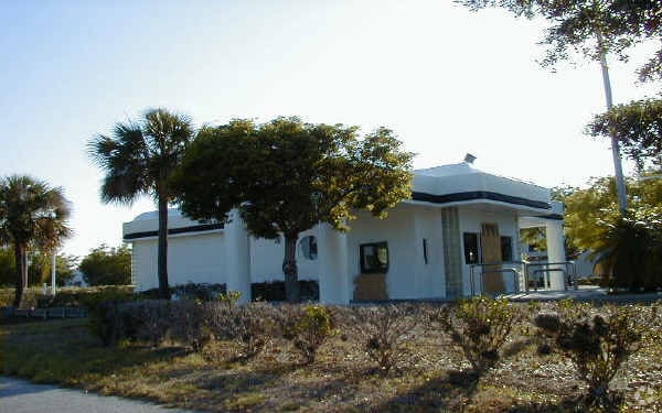
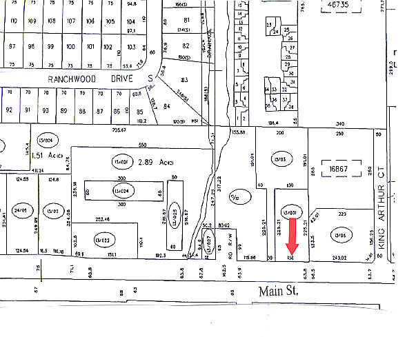
1994 Main St
25-28-15-00000-130-0310
PART OF NE 1/4 OF SEC 25-28-15 DESC AS FROM SE COR OF NE 1/4 OF SEC TH N89D1219W 1622.73FT TH N00D1913W 63.82FT FOR POB TH N89D1110W 130FT TH N00D1913W 225.21FT TH S89D1110E 130FT TH S00D1913E 225.21FT TO POB
Carwash
Pinellas
AE The base floodplain where base flood elevations are provided. AE Zones are now used on new format FIRMs instead of A1-A30 Zones.
Florida
2024
0.67 AC
2025
North Pinellas
026909
Tampa/St Petersburg
4,206 SF
Tampa-St. Petersburg-Clearwater, FL
NEARBY LISTINGS FOR SALE OR LEASE
DEMOGRAPHICS near 1994 Main St
1 mile
3 mile
5 mile
2025 Total Population
12,628
103,386
228,054
2030 Population
12,614
103,627
227,959
Pop Growth 2025-2030
(0.11%)
+ 0.23%
(0.04%)
Average Age
50
49
47
2025 Total Households
6,478
48,855
103,968
HH Growth 2025-2030
(0.46%)
+ 0.13%
(0.15%)
Median Household Inc
$63,343
$69,554
$70,325
Avg Household Size
1.90
2.00
2.10
2025 Avg HH Vehicles
1.00
2.00
2.00
Median Home Value
$356,565
$379,994
$389,397
Median Year Built
1979
1978
1979
Nearby Places
Map Layers
Map Styles
 Street
 Aerial
Layers
 Traffic
 Biking
Places
Listings with unknown addresses are not visible on the map
- Restaurants
- Banks
- Shops
- Fitness
- Groceries
PUBLIC TRANSPORTATION
AIRPORT
St Pete-Clearwater International
Drive
Walk
Distance
St Pete-Clearwater International
18 min
10.9 mi
Tampa International
Drive
Walk
Distance
Tampa International
31 min
18.8 mi
Freight Ports
Port of Tampa Bay
Drive
Walk
Distance
Port of Tampa Bay
45 min
27.3 mi
Nearby Properties
Address
Land Use
TOTAL SIZE
Lot Size
Zoning
Address
Land Use
TOTAL SIZE
Lot Size
Zoning
661,982 SF
19.26 AC
Address
Land Use
TOTAL SIZE
Lot Size
Zoning
513,938 SF
22.84 AC
Address
Land Use
TOTAL SIZE
Lot Size
Zoning
675,202 SF
43.24 AC
Address
Land Use
TOTAL SIZE
Lot Size
Zoning
724,220 SF
22.95 AC
Address
Land Use
TOTAL SIZE
Lot Size
Zoning
460,041 SF
44.28 AC
Address
Land Use
TOTAL SIZE
Lot Size
Zoning
384,016 SF
12.06 AC
Address
Land Use
TOTAL SIZE
Lot Size
Zoning
356,262 SF
15.48 AC
Address
Land Use
TOTAL SIZE
Lot Size
Zoning
167,201 SF
63.11 AC
AE
Address
Land Use
TOTAL SIZE
Lot Size
Zoning
406,729 SF
29.79 AC
CP1
Address
Land Use
TOTAL SIZE
Lot Size
Zoning
412,099 SF
49.21 AC
Address
Land Use
TOTAL SIZE
Lot Size
Zoning
278,505 SF
38.67 AC
Address
Land Use
TOTAL SIZE
Lot Size
Zoning
326,008 SF
53.12 AC
Address
Land Use
TOTAL SIZE
Lot Size
Zoning
662,010 SF
33.76 AC
Address
Land Use
TOTAL SIZE
Lot Size
Zoning
236,972 SF
19.07 AC
Address
Land Use
TOTAL SIZE
Lot Size
Zoning
242,708 SF
26.17 AC
RPD10
Address
Land Use
TOTAL SIZE
Lot Size
Zoning
321,395 SF
25.22 AC
Address
Land Use
TOTAL SIZE
Lot Size
Zoning
362,238 SF
13.80 AC
Address
Land Use
TOTAL SIZE
Lot Size
Zoning
258,472 SF
18.23 AC
Address
Land Use
TOTAL SIZE
Lot Size
Zoning
239,480 SF
18.89 AC
RPD5
Address
Land Use
TOTAL SIZE
Lot Size
Zoning
215,081 SF
16.60 AC
Address
Land Use
TOTAL SIZE
Lot Size
Zoning
367,503 SF
20.34 AC
M2
Address
Land Use
TOTAL SIZE
Lot Size
Zoning
117,024 SF
56.52 AC
Address
Land Use
TOTAL SIZE
Lot Size
Zoning
241,170 SF
17.23 AC
Address
Land Use
TOTAL SIZE
Lot Size
Zoning
151,730 SF
49.66 AC
Address
Land Use
TOTAL SIZE
Lot Size
Zoning
161,404 SF
18.48 AC
CP2
Address
Land Use
TOTAL SIZE
Lot Size
Zoning
191,375 SF
13.58 AC
AE
Address
Land Use
TOTAL SIZE
Lot Size
Zoning
186,967 SF
16.86 AC
Address
Land Use
TOTAL SIZE
Lot Size
Zoning
250,113 SF
39.50 AC
Address
Land Use
TOTAL SIZE
Lot Size
Zoning
196,808 SF
12.70 AC
Address
Land Use
TOTAL SIZE
Lot Size
Zoning
220,640 SF
9.02 AC
The World's #1 Commercial Real Estate Marketplace
Connect with us
© 2026 CoStar Group
The information above has been obtained from sources believed reliable. While we do not doubt its accuracy we have not verified it and make no guarantee, warranty or representation about it. It is your responsibility to independently confirm its accuracy and completeness. Any projections, opinions, assumptions, or estimates used are for example only and do not represent the current or future performance of the property. The value of this transaction to you depends on tax and other factors which should be evaluated by your tax, financial, and legal advisors. You and your advisors should conduct a careful, independent investigation of the property to determine to your satisfaction the suitability of the property for your needs.