Property Record
1998 Bruckner Blvd, Bronx, NY 10473
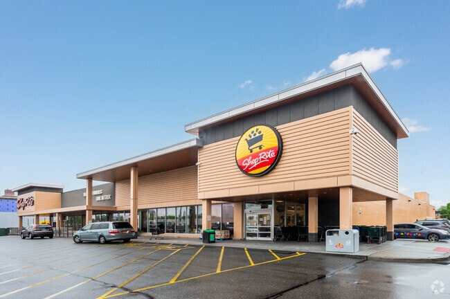


Property Detail
1998 Bruckner Blvd
03673-0002
Bronx
Storebuilding
New York
C4-1
2
B and X Area of moderate flood hazard, usually the area between the limits of the 100-year and 500-year floods.
1.38 AC
0
Bronx
2026
Westchester/So Connecticut
004200
New York-Jersey City-White Plains, NY-NJ
41,840 SF
NEARBY LISTINGS FOR SALE OR LEASE
DEMOGRAPHICS near 1998 Bruckner Blvd
1 mile
3 mile
5 mile
2025 Total Population
102,820
618,993
2,010,497
2030 Population
96,910
597,514
1,988,834
Pop Growth 2025-2030
(5.75%)
(3.47%)
(1.08%)
Average Age
39
38
40
2025 Total Households
35,393
213,166
721,685
HH Growth 2025-2030
(6.09%)
(4.02%)
(1.17%)
Median Household Inc
$46,771
$46,305
$51,466
Avg Household Size
2.80
2.70
2.60
2025 Avg HH Vehicles
1.00
1.00
1.00
Median Home Value
$578,613
$657,067
$601,041
Median Year Built
1955
1956
1953
Nearby Places
Map Layers
Map Styles
 Street
 Aerial
Layers
 Traffic
 Biking
Places
Listings with unknown addresses are not visible on the map
- Restaurants
- Banks
- Shops
- Fitness
- Groceries
PUBLIC TRANSPORTATION
TRANSIT/SUBWAY
Parkchester (6 - New York MTA Subway (The Subway))
Drive
Walk
Distance
Parkchester (6 - New York MTA Subway (The Subway))
5 min
14 min
0.8 mi
St Lawrence Avenue (6 - New York MTA Subway (The Subway))
Drive
Walk
Distance
St Lawrence Avenue (6 - New York MTA Subway (The Subway))
3 min
18 min
0.9 mi
Castle Hill Avenue (6 - New York MTA Subway (The Subway))
Drive
Walk
Distance
Castle Hill Avenue (6 - New York MTA Subway (The Subway))
3 min
18 min
1.0 mi
COMMUTER RAIL
Tremont Station (Harlem Line - Metro-North Commuter Railroad Company (Metro-North))
Drive
Walk
Distance
Tremont Station (Harlem Line - Metro-North Commuter Railroad Company (Metro-North))
7 min
3.4 mi
Melrose Station (Harlem Line - Metro-North Commuter Railroad Company (Metro-North))
Drive
Walk
Distance
Melrose Station (Harlem Line - Metro-North Commuter Railroad Company (Metro-North))
9 min
3.7 mi
AIRPORT
LaGuardia
Drive
Walk
Distance
LaGuardia
17 min
8.6 mi
John F Kennedy International
Drive
Walk
Distance
John F Kennedy International
23 min
16.2 mi
Westchester County
Drive
Walk
Distance
Westchester County
35 min
23.5 mi
Freight Ports
NY - Red Hook Container Terminal
Drive
Walk
Distance
NY - Red Hook Container Terminal
30 min
17.3 mi
SALE & LEASE HISTORY
LISTING DATE
SALE/LEASE

Sep 25, 2016
For Lease
Nearby Properties
Address
Land Use
TOTAL SIZE
Lot Size
Zoning
Address
Land Use
TOTAL SIZE
Lot Size
Zoning
5,519,372 SF
409.21 AC
C8-2
Address
Land Use
TOTAL SIZE
Lot Size
Zoning
550,000 SF
8.75 AC
M1-1
Address
Land Use
TOTAL SIZE
Lot Size
Zoning
1,427,393 SF
39.94 AC
R4
Address
Land Use
TOTAL SIZE
Lot Size
Zoning
5,000 SF
363.58 AC
PARK
Address
Land Use
TOTAL SIZE
Lot Size
Zoning
1,012,000 SF
7.79 AC
R6
Address
Land Use
TOTAL SIZE
Lot Size
Zoning
485,484 SF
39.63 AC
R5
Address
Land Use
TOTAL SIZE
Lot Size
Zoning
667,405 SF
5.51 AC
R6
Address
Land Use
TOTAL SIZE
Lot Size
Zoning
390,750 SF
265 AC
PARK
Address
Land Use
TOTAL SIZE
Lot Size
Zoning
851,821 SF
7.95 AC
R4
Address
Land Use
TOTAL SIZE
Lot Size
Zoning
426,172 SF
14.30 AC
M3-1
Address
Land Use
TOTAL SIZE
Lot Size
Zoning
491,007 SF
11.85 AC
M3-1
Address
Land Use
TOTAL SIZE
Lot Size
Zoning
489,326 SF
19.18 AC
C8-1
Address
Land Use
TOTAL SIZE
Lot Size
Zoning
14,681 SF
97 AC
PARK
Address
Land Use
TOTAL SIZE
Lot Size
Zoning
127,000 SF
16.53 AC
M3-1
Address
Land Use
TOTAL SIZE
Lot Size
Zoning
361,354 SF
C4-2
Address
Land Use
TOTAL SIZE
Lot Size
Zoning
1,172,005 SF
128.83 AC
M1-1
Address
Land Use
TOTAL SIZE
Lot Size
Zoning
510 SF
68.73 AC
PARK
Address
Land Use
TOTAL SIZE
Lot Size
Zoning
601,260 SF
3.27 AC
R4
Address
Land Use
TOTAL SIZE
Lot Size
Zoning
450,879 SF
9.10 AC
M1-1
Address
Land Use
TOTAL SIZE
Lot Size
Zoning
450,000 SF
5.59 AC
R6
Address
Land Use
TOTAL SIZE
Lot Size
Zoning
726,051 SF
33.66 AC
R5
Address
Land Use
TOTAL SIZE
Lot Size
Zoning
674,889 SF
51.55 AC
M3-1
Address
Land Use
TOTAL SIZE
Lot Size
Zoning
312,844 SF
0.44 AC
M14R7X
Address
Land Use
TOTAL SIZE
Lot Size
Zoning
274,840 SF
2.80 AC
M1-1
Address
Land Use
TOTAL SIZE
Lot Size
Zoning
140,000 SF
2.34 AC
M1-4
Address
Land Use
TOTAL SIZE
Lot Size
Zoning
1,214,370 SF
13.09 AC
R6
Address
Land Use
TOTAL SIZE
Lot Size
Zoning
16,300 SF
148.32 AC
PARK
Address
Land Use
TOTAL SIZE
Lot Size
Zoning
1,172,800 SF
19.66 AC
R4
Address
Land Use
TOTAL SIZE
Lot Size
Zoning
464,700 SF
5.07 AC
R4
Address
Land Use
TOTAL SIZE
Lot Size
Zoning
262,716 SF
2.80 AC
M1-1
The World's #1 Commercial Real Estate Marketplace
Connect with us
© 2026 CoStar Group
The information above has been obtained from sources believed reliable. While we do not doubt its accuracy we have not verified it and make no guarantee, warranty or representation about it. It is your responsibility to independently confirm its accuracy and completeness. Any projections, opinions, assumptions, or estimates used are for example only and do not represent the current or future performance of the property. The value of this transaction to you depends on tax and other factors which should be evaluated by your tax, financial, and legal advisors. You and your advisors should conduct a careful, independent investigation of the property to determine to your satisfaction the suitability of the property for your needs.