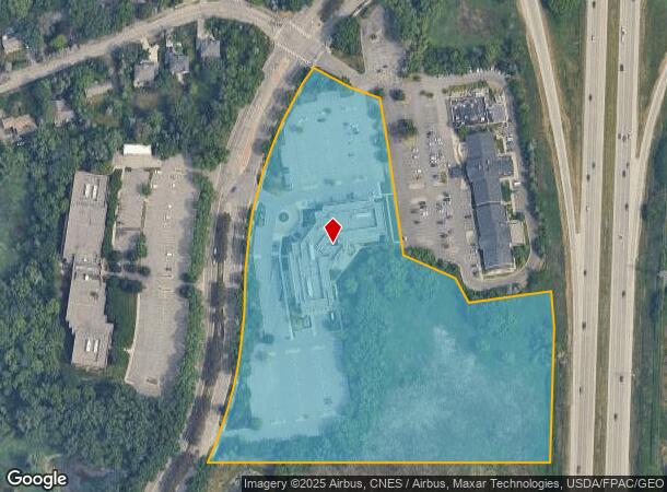
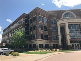
Property Record
2 Carlson Pkwy N, Minneapolis, MN 55447

Current Lease Availabilities
NEARBY LISTINGS FOR SALE OR LEASE
Property Detail
2 Carlson Pkwy N
Minneapolis-St. Paul-Bloomington, MN-WI
Carlson Center 15Th Addn
33-118-22-44-0038
LOT 001 BLOCK 001 T CARLSON CENTER 15TH ADDN LOT 1 BLK 1 EXCEPT THAT PART LYING NLY OF FOL DESC LINE COM AT SE COR OF SAID LOT 1 TH ON AN ASSUMED BRG OF N 1 DEG 27 MIN 59 SEC E ALONG E T IRREGULAR
Commercialnec
Hennepin
X
Minnesota
27053C0327F
1
2024
12.18 AC
2024
I-394 Corridor
026609
Minneapolis/St Paul
DEMOGRAPHICS near 2 Carlson Pkwy N
1 Mile
3 Mile
5 Mile
2024 Total Population
4,916
49,535
159,827
2029 Population
4,878
49,026
157,265
Pop Growth 2024-2029
(0.77%)
(1.03%)
(1.60%)
Average Age
43
43
42
2024 Total Households
2,151
21,708
67,641
HH Growth 2024-2029
(0.56%)
(1.10%)
(1.73%)
Median Household Inc
$118,222
$111,866
$103,087
Avg Household Size
2.20
2.20
2.30
2024 Avg HH Vehicles
2.00
2.00
2.00
Median Home Value
$434,696
$451,997
$397,576
Median Year Built
1985
1982
1978
Nearby Places
Map Layers
Map Styles
 Street
 Aerial
- Restaurants
- Banks
- Shops
- Fitness
- Groceries
PUBLIC TRANSPORTATION
AIRPORT
Minneapolis-St Paul International/Wold-Chamberlain
DRIVE
WALK
Distance
Minneapolis-St Paul International/Wold-Chamberlain
29 min
20.5 mi
Nearby Properties
Address
Land Use
TOTAL SIZE
Lot Size
Zoning
Address
Land Use
TOTAL SIZE
Lot Size
Zoning
35.53 AC
Address
Land Use
TOTAL SIZE
Lot Size
Zoning
324,564 SF
32.54 AC
PID
Address
Land Use
TOTAL SIZE
Lot Size
Zoning
18.27 AC
Address
Land Use
TOTAL SIZE
Lot Size
Zoning
20,710 SF
7.69 AC
PID
Address
Land Use
TOTAL SIZE
Lot Size
Zoning
20,710 SF
7.69 AC
PID
Address
Land Use
TOTAL SIZE
Lot Size
Zoning
6.47 AC
Address
Land Use
TOTAL SIZE
Lot Size
Zoning
19.46 AC
PUD
Address
Land Use
TOTAL SIZE
Lot Size
Zoning
202,718 SF
14.37 AC
PID
Address
Land Use
TOTAL SIZE
Lot Size
Zoning
196,498 SF
13.13 AC
PID
Address
Land Use
TOTAL SIZE
Lot Size
Zoning
11.93 AC
PID
Address
Land Use
TOTAL SIZE
Lot Size
Zoning
Address
Land Use
TOTAL SIZE
Lot Size
Zoning
2.58 AC
Address
Land Use
TOTAL SIZE
Lot Size
Zoning
15.86 AC
Address
Land Use
TOTAL SIZE
Lot Size
Zoning
2.38 AC
Address
Land Use
TOTAL SIZE
Lot Size
Zoning
Address
Land Use
TOTAL SIZE
Lot Size
Zoning
171,900 SF
39.17 AC
B1
Address
Land Use
TOTAL SIZE
Lot Size
Zoning
2.18 AC
Address
Land Use
TOTAL SIZE
Lot Size
Zoning
40.17 AC
Address
Land Use
TOTAL SIZE
Lot Size
Zoning
4.34 AC
Address
Land Use
TOTAL SIZE
Lot Size
Zoning
94,155 SF
2.06 AC
PUD
Address
Land Use
TOTAL SIZE
Lot Size
Zoning
10.57 AC
PID
Address
Land Use
TOTAL SIZE
Lot Size
Zoning
16.35 AC
Address
Land Use
TOTAL SIZE
Lot Size
Zoning
12.06 AC
PID
Address
Land Use
TOTAL SIZE
Lot Size
Zoning
2.12 AC
Address
Land Use
TOTAL SIZE
Lot Size
Zoning
2.69 AC
Address
Land Use
TOTAL SIZE
Lot Size
Zoning
14.36 AC
PID
Address
Land Use
TOTAL SIZE
Lot Size
Zoning
237,757 SF
7.12 AC
Address
Land Use
TOTAL SIZE
Lot Size
Zoning
198,528 SF
6.05 AC
Address
Land Use
TOTAL SIZE
Lot Size
Zoning
43,180 SF
10.28 AC
PID
Address
Land Use
TOTAL SIZE
Lot Size
Zoning
43,180 SF
10.94 AC
PID
The World's #1 Commercial Real Estate Marketplace
Connect with us
© 2026 CoStar Group
The information above has been obtained from sources believed reliable. While we do not doubt its accuracy we have not verified it and make no guarantee, warranty or representation about it. It is your responsibility to independently confirm its accuracy and completeness. Any projections, opinions, assumptions, or estimates used are for example only and do not represent the current or future performance of the property. The value of this transaction to you depends on tax and other factors which should be evaluated by your tax, financial, and legal advisors. You and your advisors should conduct a careful, independent investigation of the property to determine to your satisfaction the suitability of the property for your needs.