Property Record
2 Jarves St, Sandwich, MA 02563
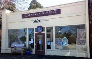

Property Detail
2 Jarves St
Storebuilding
BARNSTABLE
VILLAG
Massachusetts
B and X Area of moderate flood hazard, usually the area between the limits of the 100-year and 500-year floods.
0.04 AC
2025
Cape Cod
2025
Other Market Areas
013600
Barnstable Town, MA
1,560 SF
SAND-000073-000030
NEARBY LISTINGS FOR SALE OR LEASE
DEMOGRAPHICS near 2 Jarves St
1 mile
3 mile
5 mile
2025 Total Population
2,221
6,638
18,368
2030 Population
2,140
6,345
17,750
Pop Growth 2025-2030
(3.65%)
(4.41%)
(3.36%)
Average Age
53
49
47
2025 Total Households
1,049
2,814
7,384
HH Growth 2025-2030
(4.19%)
(4.87%)
(3.68%)
Median Household Inc
$103,307
$103,954
$111,241
Avg Household Size
2.00
2.30
2.40
2025 Avg HH Vehicles
2.00
2.00
2.00
Median Home Value
$637,609
$625,590
$605,899
Median Year Built
1964
1975
1981
Nearby Places
Map Layers
Map Styles
 Street
 Aerial
Layers
 Traffic
 Biking
Places
Listings with unknown addresses are not visible on the map
- Restaurants
- Banks
- Shops
- Fitness
- Groceries
PUBLIC TRANSPORTATION
COMMUTER RAIL
Drive
Walk
Distance
12 min
6.6 mi
Drive
Walk
Distance
17 min
9.2 mi
AIRPORT
Martha's Vineyard
Drive
Walk
Distance
Martha's Vineyard
100 min
37.3 mi
Nantucket Memorial
Drive
Walk
Distance
Nantucket Memorial
174 min
48.1 mi
SALE & LEASE HISTORY
LISTING DATE
SALE/LEASE

Sep 24, 2016
For Sale
Feb 06, 2020
For Sale
Nearby Properties
Address
Land Use
TOTAL SIZE
Lot Size
Zoning
Address
Land Use
TOTAL SIZE
Lot Size
Zoning
270,790 SF
62.90 AC
R-2
Address
Land Use
TOTAL SIZE
Lot Size
Zoning
125,550 SF
45.57 AC
RIDGE
Address
Land Use
TOTAL SIZE
Lot Size
Zoning
654.71 AC
R40
Address
Land Use
TOTAL SIZE
Lot Size
Zoning
Address
Land Use
TOTAL SIZE
Lot Size
Zoning
2,295.68 AC
R-1
Address
Land Use
TOTAL SIZE
Lot Size
Zoning
16.20 AC
BL-1
Address
Land Use
TOTAL SIZE
Lot Size
Zoning
325 AC
R-1
Address
Land Use
TOTAL SIZE
Lot Size
Zoning
46.68 AC
R-1
Address
Land Use
TOTAL SIZE
Lot Size
Zoning
38.35 AC
RIDGE
Address
Land Use
TOTAL SIZE
Lot Size
Zoning
148.70 AC
R40
Address
Land Use
TOTAL SIZE
Lot Size
Zoning
Address
Land Use
TOTAL SIZE
Lot Size
Zoning
29.83 AC
IND
Address
Land Use
TOTAL SIZE
Lot Size
Zoning
41.40 AC
IND
Address
Land Use
TOTAL SIZE
Lot Size
Zoning
4.94 AC
VILLAG
Address
Land Use
TOTAL SIZE
Lot Size
Zoning
11.97 AC
MARINE
Address
Land Use
TOTAL SIZE
Lot Size
Zoning
31.50 AC
MARINE
Address
Land Use
TOTAL SIZE
Lot Size
Zoning
83.01 AC
R-2
Address
Land Use
TOTAL SIZE
Lot Size
Zoning
36,388 SF
6.70 AC
BL-1
Address
Land Use
TOTAL SIZE
Lot Size
Zoning
40,476 SF
7 AC
BL-1
Address
Land Use
TOTAL SIZE
Lot Size
Zoning
17,110 SF
1.68 AC
R-1
Address
Land Use
TOTAL SIZE
Lot Size
Zoning
39,202 SF
6.31 AC
BL-1
Address
Land Use
TOTAL SIZE
Lot Size
Zoning
60,820 SF
9.11 AC
FLEX
Address
Land Use
TOTAL SIZE
Lot Size
Zoning
610 SF
24.11 AC
R-1
Address
Land Use
TOTAL SIZE
Lot Size
Zoning
21.30 AC
IND
Address
Land Use
TOTAL SIZE
Lot Size
Zoning
4,146 SF
11.40 AC
BL-1
Address
Land Use
TOTAL SIZE
Lot Size
Zoning
8,989 SF
1.19 AC
MARINE
Address
Land Use
TOTAL SIZE
Lot Size
Zoning
Address
Land Use
TOTAL SIZE
Lot Size
Zoning
95.35 AC
RIDGE
Address
Land Use
TOTAL SIZE
Lot Size
Zoning
16,449 SF
4.21 AC
Address
Land Use
TOTAL SIZE
Lot Size
Zoning
10,691 SF
0.75 AC
VILLAG
The World's #1 Commercial Real Estate Marketplace
Connect with us
© 2026 CoStar Group
The information above has been obtained from sources believed reliable. While we do not doubt its accuracy we have not verified it and make no guarantee, warranty or representation about it. It is your responsibility to independently confirm its accuracy and completeness. Any projections, opinions, assumptions, or estimates used are for example only and do not represent the current or future performance of the property. The value of this transaction to you depends on tax and other factors which should be evaluated by your tax, financial, and legal advisors. You and your advisors should conduct a careful, independent investigation of the property to determine to your satisfaction the suitability of the property for your needs.