Property Record
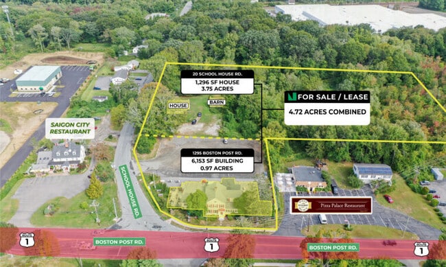
20 School House Rd, Old Saybrook, CT 06475
This Property Is For Sale
NEARBY LISTINGS FOR SALE OR LEASE
Property Detail
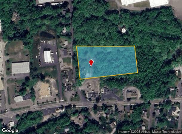
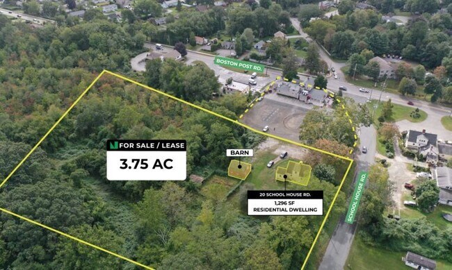
20 School House Rd
Sfr
Middlesex
X
Connecticut
09007C0342J
3.75 AC
2025
SW Midlsx/Old Saybrk/Rt 9
2025
Hartford
670100
Hartford-West Hartford-East Hartford, CT
1,296 SF
OSAY-000027-000032
DEMOGRAPHICS near 20 School House Rd
1 mile
3 mile
5 mile
2024 Total Population
3,206
15,940
27,641
2029 Population
3,382
16,440
28,185
Pop Growth 2024-2029
+ 5.49%
+ 3.14%
+ 1.97%
Average Age
51
50
50
2024 Total Households
1,466
7,147
12,405
HH Growth 2024-2029
+ 5.53%
+ 3.27%
+ 2.05%
Median Household Inc
$107,177
$96,549
$98,406
Avg Household Size
2.10
2.20
2.20
2024 Avg HH Vehicles
2.00
2.00
2.00
Median Home Value
$378,720
$415,876
$426,301
Median Year Built
1965
1971
1970
Nearby Places
Map Layers
Map Styles
 Street
 Aerial
Transit
 Traffic
 Biking
Places
Listings with unknown addresses are not visible on the map
- Restaurants
- Banks
- Shops
- Fitness
- Groceries
PUBLIC TRANSPORTATION
COMMUTER RAIL
Old Saybrook (Shore Line East - Shore Line East)
Drive
Walk
Distance
Old Saybrook (Shore Line East - Shore Line East)
4 min
2.0 mi
Westbrook (Shore Line East - Shore Line East)
Drive
Walk
Distance
Westbrook (Shore Line East - Shore Line East)
5 min
3.0 mi
AIRPORT
Tweed/New Haven
Drive
Walk
Distance
Tweed/New Haven
36 min
26.9 mi
Freight Ports
Port of New Haven
Drive
Walk
Distance
Port of New Haven
36 min
27.5 mi
Nearby Properties
Address
Land Use
TOTAL SIZE
Lot Size
Zoning
Address
Land Use
TOTAL SIZE
Lot Size
Zoning
10.78 AC
B-2
Address
Land Use
TOTAL SIZE
Lot Size
Zoning
91,300 SF
8.03 AC
TIC
Address
Land Use
TOTAL SIZE
Lot Size
Zoning
159,832 SF
110.10 AC
RR
Address
Land Use
TOTAL SIZE
Lot Size
Zoning
14.87 AC
NCD
Address
Land Use
TOTAL SIZE
Lot Size
Zoning
35.40 AC
B-2
Address
Land Use
TOTAL SIZE
Lot Size
Zoning
39.32 AC
LI/LDR
Address
Land Use
TOTAL SIZE
Lot Size
Zoning
40,942 SF
7.45 AC
A
Address
Land Use
TOTAL SIZE
Lot Size
Zoning
83,486 SF
3.71 AC
SP-2
Address
Land Use
TOTAL SIZE
Lot Size
Zoning
20.17 AC
A
Address
Land Use
TOTAL SIZE
Lot Size
Zoning
14.78 AC
B-4
Address
Land Use
TOTAL SIZE
Lot Size
Zoning
46.69 AC
MDR
Address
Land Use
TOTAL SIZE
Lot Size
Zoning
49.71 AC
TIC
Address
Land Use
TOTAL SIZE
Lot Size
Zoning
101,587 SF
34.34 AC
A
Address
Land Use
TOTAL SIZE
Lot Size
Zoning
14.25 AC
A
Address
Land Use
TOTAL SIZE
Lot Size
Zoning
8,565 SF
2.08 AC
AA-2
Address
Land Use
TOTAL SIZE
Lot Size
Zoning
8,699 SF
1.52 AC
AA-2
Address
Land Use
TOTAL SIZE
Lot Size
Zoning
80.46 AC
AA-2
Address
Land Use
TOTAL SIZE
Lot Size
Zoning
11,373 SF
0.66 AC
AA-2
Address
Land Use
TOTAL SIZE
Lot Size
Zoning
72,128 SF
22.08 AC
I-1
Address
Land Use
TOTAL SIZE
Lot Size
Zoning
10.80 AC
I-1
Address
Land Use
TOTAL SIZE
Lot Size
Zoning
22,984 SF
6.58 AC
MDR
Address
Land Use
TOTAL SIZE
Lot Size
Zoning
17,833 SF
3.87 AC
A
Address
Land Use
TOTAL SIZE
Lot Size
Zoning
7.36 AC
B1
Address
Land Use
TOTAL SIZE
Lot Size
Zoning
25,144 SF
3.74 AC
B-4
Address
Land Use
TOTAL SIZE
Lot Size
Zoning
24,360 SF
7.78 AC
B-2
Address
Land Use
TOTAL SIZE
Lot Size
Zoning
64,427 SF
1.46 AC
Address
Land Use
TOTAL SIZE
Lot Size
Zoning
291,816 SF
29.64 AC
I-1
Address
Land Use
TOTAL SIZE
Lot Size
Zoning
5,470 SF
1.48 AC
AA-2
Address
Land Use
TOTAL SIZE
Lot Size
Zoning
9,244 SF
1.10 AC
AA-2
Address
Land Use
TOTAL SIZE
Lot Size
Zoning
52,960 SF
32 AC
AA1
The World's #1 Commercial Real Estate Marketplace
Connect with us
© 2026 CoStar Group
The information above has been obtained from sources believed reliable. While we do not doubt its accuracy we have not verified it and make no guarantee, warranty or representation about it. It is your responsibility to independently confirm its accuracy and completeness. Any projections, opinions, assumptions, or estimates used are for example only and do not represent the current or future performance of the property. The value of this transaction to you depends on tax and other factors which should be evaluated by your tax, financial, and legal advisors. You and your advisors should conduct a careful, independent investigation of the property to determine to your satisfaction the suitability of the property for your needs.