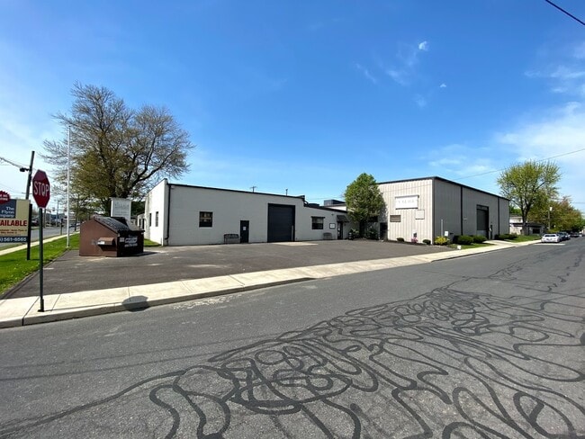
Property Record
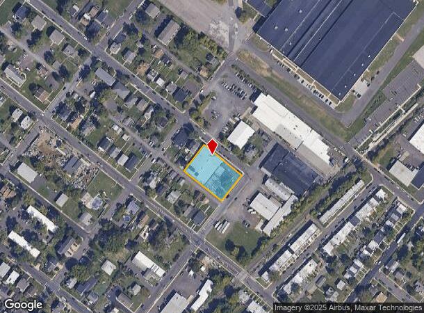
200 W 8Th St, Lansdale, PA 19446

Current Lease Availabilities
NEARBY LISTINGS FOR SALE OR LEASE
Property Detail
200 W 8Th St
Philadelphia-Camden-Wilmington, PA-NJ-DE-MD
Np Indust Center Incorpora
11-00-04672-006
359 X 150 31433 SF
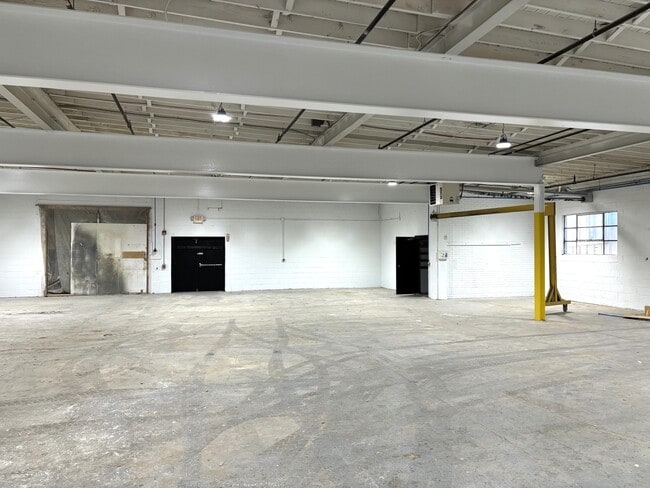
Warehouse
Montgomery
X
Pennsylvania
42091C0256G
42
2024
0.72 AC
2025
East Montgomery Cty
200901
Philadelphia
21,644 SF
DEMOGRAPHICS near 200 W 8Th St
1 Mile
3 Mile
5 Mile
2024 Total Population
16,293
81,611
152,234
2029 Population
16,655
82,937
154,328
Pop Growth 2024-2029
+ 2.22%
+ 1.62%
+ 1.38%
Average Age
39
42
43
2024 Total Households
6,145
31,677
58,516
HH Growth 2024-2029
+ 2.16%
+ 1.50%
+ 1.31%
Median Household Inc
$86,000
$96,981
$106,460
Avg Household Size
2.50
2.50
2.50
2024 Avg HH Vehicles
2.00
2.00
2.00
Median Home Value
$282,386
$356,645
$394,928
Median Year Built
1956
1976
1981
Nearby Places
Map Layers
Map Styles
 Street
 Aerial
- Restaurants
- Banks
- Shops
- Fitness
- Groceries
PUBLIC TRANSPORTATION
TRANSIT/SUBWAY
Lansdale (R5 - Southeastern Pennsylvania Transportation Authority Regional Rail (SEPTA Regional Rail))
DRIVE
WALK
Distance
Lansdale (R5 - Southeastern Pennsylvania Transportation Authority Regional Rail (SEPTA Regional Rail))
3 min
14 min
0.7 mi
COMMUTER RAIL
DRIVE
WALK
Distance
2 min
5 min
0.3 mi
Lansdale (R5 - Southeastern Pennsylvania Transportation Authority Regional Rail (SEPTA Regional Rail))
DRIVE
WALK
Distance
Lansdale (R5 - Southeastern Pennsylvania Transportation Authority Regional Rail (SEPTA Regional Rail))
3 min
13 min
0.7 mi
AIRPORT
Lehigh Valley International
DRIVE
WALK
Distance
Lehigh Valley International
57 min
33.8 mi
Trenton Mercer
DRIVE
WALK
Distance
Trenton Mercer
58 min
36.5 mi
Philadelphia International
DRIVE
WALK
Distance
Philadelphia International
61 min
41.4 mi
Freight Ports
Port of Philadelphia
DRIVE
WALK
Distance
Port of Philadelphia
44 min
24.8 mi
Nearby Properties
Address
Land Use
TOTAL SIZE
Lot Size
Zoning
Address
Land Use
TOTAL SIZE
Lot Size
Zoning
7,622,512 SF
315.44 AC
LI
Address
Land Use
TOTAL SIZE
Lot Size
Zoning
1,744,364 SF
91.78 AC
LI
Address
Land Use
TOTAL SIZE
Lot Size
Zoning
519,907 SF
91.44 AC
R125
Address
Land Use
TOTAL SIZE
Lot Size
Zoning
404,986 SF
22.21 AC
I
Address
Land Use
TOTAL SIZE
Lot Size
Zoning
258,179 SF
65.34 AC
IN
Address
Land Use
TOTAL SIZE
Lot Size
Zoning
629,336 SF
31.74 AC
IN
Address
Land Use
TOTAL SIZE
Lot Size
Zoning
977,439 SF
70.93 AC
GA
Address
Land Use
TOTAL SIZE
Lot Size
Zoning
268,288 SF
30.59 AC
RA
Address
Land Use
TOTAL SIZE
Lot Size
Zoning
444,426 SF
30 AC
GA
Address
Land Use
TOTAL SIZE
Lot Size
Zoning
1,127,663 SF
14.16 AC
RS
Address
Land Use
TOTAL SIZE
Lot Size
Zoning
454,126 SF
37.18 AC
MRC
Address
Land Use
TOTAL SIZE
Lot Size
Zoning
319,136 SF
18.35 AC
HDR
Address
Land Use
TOTAL SIZE
Lot Size
Zoning
301,431 SF
41.90 AC
S
Address
Land Use
TOTAL SIZE
Lot Size
Zoning
517,834 SF
31.33 AC
GA
Address
Land Use
TOTAL SIZE
Lot Size
Zoning
253,741 SF
9.09 AC
VO
Address
Land Use
TOTAL SIZE
Lot Size
Zoning
832,830 SF
53.72 AC
LI
Address
Land Use
TOTAL SIZE
Lot Size
Zoning
245,104 SF
31.21 AC
C
Address
Land Use
TOTAL SIZE
Lot Size
Zoning
253,915 SF
17.78 AC
GA
Address
Land Use
TOTAL SIZE
Lot Size
Zoning
199,368 SF
24.65 AC
RC
Address
Land Use
TOTAL SIZE
Lot Size
Zoning
219,869 SF
41.98 AC
LI
Address
Land Use
TOTAL SIZE
Lot Size
Zoning
225,154 SF
6.38 AC
B
Address
Land Use
TOTAL SIZE
Lot Size
Zoning
767,474 SF
64.82 AC
RC
Address
Land Use
TOTAL SIZE
Lot Size
Zoning
373,104 SF
31.94 AC
LI
Address
Land Use
TOTAL SIZE
Lot Size
Zoning
170,351 SF
71.70 AC
IN
Address
Land Use
TOTAL SIZE
Lot Size
Zoning
334,450 SF
18.86 AC
GA
Address
Land Use
TOTAL SIZE
Lot Size
Zoning
179,930 SF
16 AC
IN
Address
Land Use
TOTAL SIZE
Lot Size
Zoning
139,081 SF
15.20 AC
LI
Address
Land Use
TOTAL SIZE
Lot Size
Zoning
142,336 SF
3.17 AC
RS
Address
Land Use
TOTAL SIZE
Lot Size
Zoning
131,631 SF
18.12 AC
SC
Address
Land Use
TOTAL SIZE
Lot Size
Zoning
337,074 SF
12.92 AC
A
The World's #1 Commercial Real Estate Marketplace
Connect with us
© 2026 CoStar Group
The information above has been obtained from sources believed reliable. While we do not doubt its accuracy we have not verified it and make no guarantee, warranty or representation about it. It is your responsibility to independently confirm its accuracy and completeness. Any projections, opinions, assumptions, or estimates used are for example only and do not represent the current or future performance of the property. The value of this transaction to you depends on tax and other factors which should be evaluated by your tax, financial, and legal advisors. You and your advisors should conduct a careful, independent investigation of the property to determine to your satisfaction the suitability of the property for your needs.