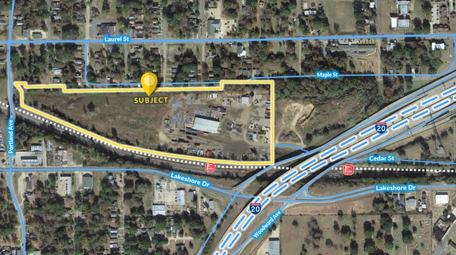
Property Record
2115 Mabel St, Shreveport, LA 71103

Save to a Folder
{{folder.Name}}
{{folder.ListingIds.length}} Properties
{{folder.ListingIds.length}} Property
Create a New Folder
Current Lease Availabilities
Property Detail
2115 Mabel St
171402-035-0013-00
23.40 ACRES-M/L-A TRACT OF LAND IN THE NW/4 OFNE/4 OF SEC. 2-17-14 PER ASSRS CITY PLAT171402-35-13
Commercialnec
CADDO
B and X Area of moderate flood hazard, usually the area between the limits of the 100-year and 500-year floods.
Louisiana
2025
23.40 AC
2025
Central
021800
Shreveport/Bossier City
100 SF
Shreveport-Bossier City, LA
NEARBY LISTINGS FOR SALE OR LEASE
DEMOGRAPHICS near 2115 Mabel St
1 mile
3 mile
5 mile
2025 Total Population
5,851
51,213
126,752
2030 Population
5,893
50,687
124,752
Pop Growth 2025-2030
+ 0.72%
(1.03%)
(1.58%)
Average Age
43
40
40
2025 Total Households
2,512
21,901
53,355
HH Growth 2025-2030
+ 0.56%
(1.24%)
(1.77%)
Median Household Inc
$26,767
$36,828
$40,644
Avg Household Size
2.20
2.20
2.20
2025 Avg HH Vehicles
1.00
1.00
1.00
Median Home Value
$67,690
$107,637
$130,500
Median Year Built
1961
1961
1965
Nearby Places
Map Layers
Map Styles
 Street
 Aerial
Layers
 Traffic
 Biking
Places
Listings with unknown addresses are not visible on the map
- Restaurants
- Banks
- Shops
- Fitness
- Groceries
PUBLIC TRANSPORTATION
AIRPORT
Shreveport Regional
Drive
Walk
Distance
Shreveport Regional
14 min
7.0 mi
Nearby Properties
Address
Land Use
TOTAL SIZE
Lot Size
Zoning
Address
Land Use
TOTAL SIZE
Lot Size
Zoning
100 SF
23.59 AC
Address
Land Use
TOTAL SIZE
Lot Size
Zoning
66,239 SF
111 AC
Address
Land Use
TOTAL SIZE
Lot Size
Zoning
100 SF
7.17 AC
Address
Land Use
TOTAL SIZE
Lot Size
Zoning
239,598 SF
4.10 AC
Address
Land Use
TOTAL SIZE
Lot Size
Zoning
Address
Land Use
TOTAL SIZE
Lot Size
Zoning
100 SF
9.54 AC
Address
Land Use
TOTAL SIZE
Lot Size
Zoning
100 SF
25.65 AC
Address
Land Use
TOTAL SIZE
Lot Size
Zoning
280,756 SF
3 AC
Address
Land Use
TOTAL SIZE
Lot Size
Zoning
Address
Land Use
TOTAL SIZE
Lot Size
Zoning
100 SF
108.03 AC
Address
Land Use
TOTAL SIZE
Lot Size
Zoning
100 SF
7.71 AC
Address
Land Use
TOTAL SIZE
Lot Size
Zoning
Address
Land Use
TOTAL SIZE
Lot Size
Zoning
100 SF
0.74 AC
Address
Land Use
TOTAL SIZE
Lot Size
Zoning
100 SF
3.37 AC
Address
Land Use
TOTAL SIZE
Lot Size
Zoning
100 SF
18.80 AC
Address
Land Use
TOTAL SIZE
Lot Size
Zoning
100 SF
1.34 AC
Address
Land Use
TOTAL SIZE
Lot Size
Zoning
100 SF
4.21 AC
Address
Land Use
TOTAL SIZE
Lot Size
Zoning
100 SF
3.08 AC
Address
Land Use
TOTAL SIZE
Lot Size
Zoning
100 SF
20 AC
Address
Land Use
TOTAL SIZE
Lot Size
Zoning
Address
Land Use
TOTAL SIZE
Lot Size
Zoning
100 SF
24.42 AC
Address
Land Use
TOTAL SIZE
Lot Size
Zoning
100 SF
4.19 AC
Address
Land Use
TOTAL SIZE
Lot Size
Zoning
100 SF
0.48 AC
Address
Land Use
TOTAL SIZE
Lot Size
Zoning
100 SF
10.91 AC
Address
Land Use
TOTAL SIZE
Lot Size
Zoning
100 SF
4.78 AC
Address
Land Use
TOTAL SIZE
Lot Size
Zoning
100 SF
13.17 AC
Address
Land Use
TOTAL SIZE
Lot Size
Zoning
100 SF
2.48 AC
Address
Land Use
TOTAL SIZE
Lot Size
Zoning
100 SF
6.52 AC
Address
Land Use
TOTAL SIZE
Lot Size
Zoning
100 SF
2.59 AC
Address
Land Use
TOTAL SIZE
Lot Size
Zoning
100 SF
3.98 AC
The World's #1 Commercial Real Estate Marketplace
Connect with us
© 2026 CoStar Group
The information above has been obtained from sources believed reliable. While we do not doubt its accuracy we have not verified it and make no guarantee, warranty or representation about it. It is your responsibility to independently confirm its accuracy and completeness. Any projections, opinions, assumptions, or estimates used are for example only and do not represent the current or future performance of the property. The value of this transaction to you depends on tax and other factors which should be evaluated by your tax, financial, and legal advisors. You and your advisors should conduct a careful, independent investigation of the property to determine to your satisfaction the suitability of the property for your needs.