Property Record
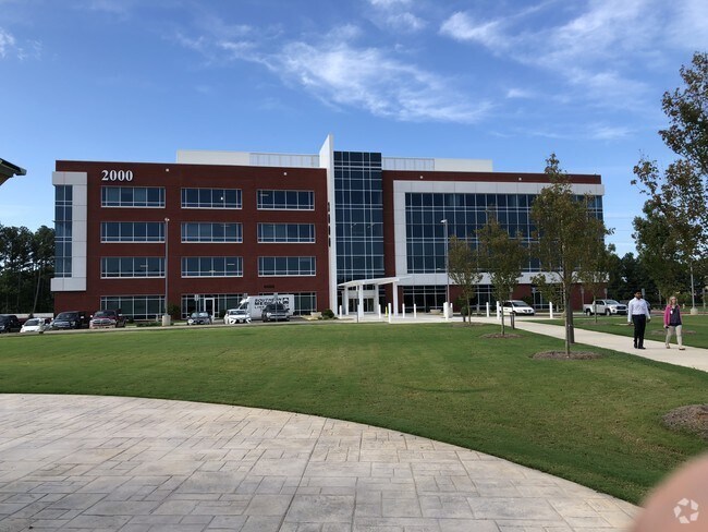
2000 Howard Farm Dr, Cumming, GA 30041


Current Lease Availabilities
NEARBY LISTINGS FOR SALE OR LEASE
Property Detail
2000 Howard Farm Dr
152-021
Market Place Dis
Commercialnec
2-1 225-226-ETAL
AE
Forsyth
13117C0142F
Georgia
2024
43.76 AC
2025
N Fulton/Forsyth County
130509
Atlanta
149,540 SF
Atlanta-Sandy Springs-Roswell, GA
DEMOGRAPHICS near 2000 Howard Farm Dr
1 Mile
3 Mile
5 Mile
2024 Total Population
4,053
48,874
125,042
2029 Population
4,724
56,821
144,867
Pop Growth 2024-2029
+ 16.56%
+ 16.26%
+ 15.85%
Average Age
37
39
39
2024 Total Households
1,381
16,642
41,815
HH Growth 2024-2029
+ 16.44%
+ 16.38%
+ 15.98%
Median Household Inc
$111,014
$113,316
$123,218
Avg Household Size
2.90
2.90
2.90
2024 Avg HH Vehicles
2.00
2.00
2.00
Median Home Value
$442,944
$423,314
$452,418
Median Year Built
2009
2004
2004
Nearby Places
Map Layers
Map Styles
 Street
 Aerial
- Restaurants
- Banks
- Shops
- Fitness
- Groceries
Nearby Properties
Address
Land Use
TOTAL SIZE
Lot Size
Zoning
Address
Land Use
TOTAL SIZE
Lot Size
Zoning
581,433 SF
31.45 AC
INST
Address
Land Use
TOTAL SIZE
Lot Size
Zoning
8,848 SF
15.75 AC
PUD
Address
Land Use
TOTAL SIZE
Lot Size
Zoning
475,011 SF
39.64 AC
CBD
Address
Land Use
TOTAL SIZE
Lot Size
Zoning
10.82 AC
PUD
Address
Land Use
TOTAL SIZE
Lot Size
Zoning
10.57 AC
PUD
Address
Land Use
TOTAL SIZE
Lot Size
Zoning
15,081 SF
27.53 AC
R3
Address
Land Use
TOTAL SIZE
Lot Size
Zoning
208,496 SF
23.61 AC
R3
Address
Land Use
TOTAL SIZE
Lot Size
Zoning
312,095 SF
28.86 AC
PSC
Address
Land Use
TOTAL SIZE
Lot Size
Zoning
29,763 SF
20.36 AC
MP
Address
Land Use
TOTAL SIZE
Lot Size
Zoning
302,599 SF
35.89 AC
R3
Address
Land Use
TOTAL SIZE
Lot Size
Zoning
15,600 SF
21.98 AC
R3
Address
Land Use
TOTAL SIZE
Lot Size
Zoning
173,374 SF
32.90 AC
CBD
Address
Land Use
TOTAL SIZE
Lot Size
Zoning
141,650 SF
21.58 AC
M1
Address
Land Use
TOTAL SIZE
Lot Size
Zoning
6.49 AC
PUD
Address
Land Use
TOTAL SIZE
Lot Size
Zoning
171,065 SF
16.22 AC
CBD
Address
Land Use
TOTAL SIZE
Lot Size
Zoning
60,235 SF
11.94 AC
CBD
Address
Land Use
TOTAL SIZE
Lot Size
Zoning
42.50 AC
RES3
Address
Land Use
TOTAL SIZE
Lot Size
Zoning
192,316 SF
51.53 AC
A1
Address
Land Use
TOTAL SIZE
Lot Size
Zoning
24.78 AC
INST
Address
Land Use
TOTAL SIZE
Lot Size
Zoning
16.56 AC
MP
Address
Land Use
TOTAL SIZE
Lot Size
Zoning
120,750 SF
9.37 AC
INST
Address
Land Use
TOTAL SIZE
Lot Size
Zoning
65,364 SF
15.29 AC
PSC
Address
Land Use
TOTAL SIZE
Lot Size
Zoning
152,562 SF
12.80 AC
R3
Address
Land Use
TOTAL SIZE
Lot Size
Zoning
290,701 SF
70.48 AC
A1
Address
Land Use
TOTAL SIZE
Lot Size
Zoning
1,600 SF
85.02 AC
RES3
Address
Land Use
TOTAL SIZE
Lot Size
Zoning
80,598 SF
10.07 AC
CBD
Address
Land Use
TOTAL SIZE
Lot Size
Zoning
2,376 SF
68.90 AC
A1
Address
Land Use
TOTAL SIZE
Lot Size
Zoning
127,940 SF
14.30 AC
HB
Address
Land Use
TOTAL SIZE
Lot Size
Zoning
99,232 SF
The World's #1 Commercial Real Estate Marketplace
Connect with us
© 2026 CoStar Group
The information above has been obtained from sources believed reliable. While we do not doubt its accuracy we have not verified it and make no guarantee, warranty or representation about it. It is your responsibility to independently confirm its accuracy and completeness. Any projections, opinions, assumptions, or estimates used are for example only and do not represent the current or future performance of the property. The value of this transaction to you depends on tax and other factors which should be evaluated by your tax, financial, and legal advisors. You and your advisors should conduct a careful, independent investigation of the property to determine to your satisfaction the suitability of the property for your needs.