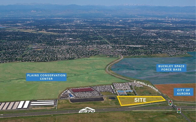
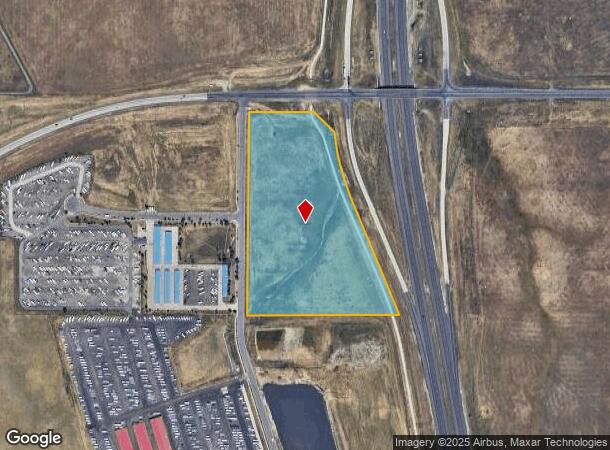
Property Record
2000 S Rome Way, Aurora, CO 80018
NEARBY LISTINGS FOR SALE OR LEASE
Property Detail
2000 S Rome Way
1975-25-2-00-005
SECTION 25 TOWNSHIP 04 RANGE 66 THAT PART OF THE N 1/2 OF THE NW 1/4 OF SEC 25-4-66 DESC AS BEG 221.84 FT W OF THE SE COR OF SD N 1/2 OF THE NW 1/4 TH ALG CURVE TO LEFT 62.64 FT TH NW 702.32 FT TH ALG CURVE RT 408.05 FT TH NW 173.49 FT TH W 391.01 FT
Vacantlandnec
Arapahoe
X
Colorado
08005C0211L
30 AC
2024
Aurora
2025
Denver
007108
Denver-Aurora-Centennial, CO
DEMOGRAPHICS near 2000 S Rome Way
1 Mile
3 Mile
5 Mile
2024 Total Population
324
52,654
197,335
2029 Population
325
52,557
198,192
Pop Growth 2024-2029
+ 0.31%
(0.18%)
+ 0.43%
Average Age
39
37
37
2024 Total Households
103
17,723
67,001
HH Growth 2024-2029
0.00%
(0.28%)
+ 0.34%
Median Household Inc
$128,472
$105,372
$92,274
Avg Household Size
3.00
2.90
2.80
2024 Avg HH Vehicles
3.00
2.00
2.00
Median Home Value
$475,489
$425,803
$423,251
Median Year Built
2005
1996
1988
Nearby Places
Map Layers
Map Styles
 Street
 Aerial
- Restaurants
- Banks
- Shops
- Fitness
- Groceries
PUBLIC TRANSPORTATION
COMMUTER RAIL
40Th Ave & Airport Blvd - Gateway Park Station Track 2 (Union Station to Denver Airport Station - Regional Transportation District)
DRIVE
WALK
Distance
40Th Ave & Airport Blvd - Gateway Park Station Track 2 (Union Station to Denver Airport Station - Regional Transportation District)
14 min
9.2 mi
AIRPORT
Denver International
DRIVE
WALK
Distance
Denver International
19 min
17.0 mi
Freight Ports
Tulsa Port Of Catoosa
DRIVE
WALK
Distance
Tulsa Port Of Catoosa
712 min
696.9 mi
SALE & LEASE HISTORY
LISTING DATE
SALE/LEASE

Sep 24, 2016
For Sale
Nov 20, 2017
For Sale
Apr 15, 2025
For Sale
Nearby Properties
Address
Land Use
TOTAL SIZE
Lot Size
Zoning
Address
Land Use
TOTAL SIZE
Lot Size
Zoning
355,937 SF
19.66 AC
RPD
Address
Land Use
TOTAL SIZE
Lot Size
Zoning
277,940 SF
31.61 AC
Address
Land Use
TOTAL SIZE
Lot Size
Zoning
142,378 SF
14.64 AC
Address
Land Use
TOTAL SIZE
Lot Size
Zoning
4,080 SF
116.55 AC
Address
Land Use
TOTAL SIZE
Lot Size
Zoning
135,050 SF
19.38 AC
Address
Land Use
TOTAL SIZE
Lot Size
Zoning
105,244 SF
12.64 AC
RPCZD
Address
Land Use
TOTAL SIZE
Lot Size
Zoning
473.14 AC
AA1
Address
Land Use
TOTAL SIZE
Lot Size
Zoning
254,752 SF
14.71 AC
RZMF
Address
Land Use
TOTAL SIZE
Lot Size
Zoning
70,715 SF
13.57 AC
Address
Land Use
TOTAL SIZE
Lot Size
Zoning
44.65 AC
Address
Land Use
TOTAL SIZE
Lot Size
Zoning
36.34 AC
Address
Land Use
TOTAL SIZE
Lot Size
Zoning
29,361 SF
4.60 AC
RB1
Address
Land Use
TOTAL SIZE
Lot Size
Zoning
19.54 AC
RZSFD
Address
Land Use
TOTAL SIZE
Lot Size
Zoning
15.04 AC
Address
Land Use
TOTAL SIZE
Lot Size
Zoning
234,516 SF
11.29 AC
RZMF
Address
Land Use
TOTAL SIZE
Lot Size
Zoning
104,823 SF
3.42 AC
RPCZD
Address
Land Use
TOTAL SIZE
Lot Size
Zoning
57,916 SF
9.07 AC
Address
Land Use
TOTAL SIZE
Lot Size
Zoning
182,199 SF
6.01 AC
Address
Land Use
TOTAL SIZE
Lot Size
Zoning
55,800 SF
7.20 AC
AMU
Address
Land Use
TOTAL SIZE
Lot Size
Zoning
185,224 SF
8 AC
PUD
Address
Land Use
TOTAL SIZE
Lot Size
Zoning
58,440 SF
7.02 AC
Address
Land Use
TOTAL SIZE
Lot Size
Zoning
19.43 AC
Address
Land Use
TOTAL SIZE
Lot Size
Zoning
36,000 SF
6.17 AC
RZOP
Address
Land Use
TOTAL SIZE
Lot Size
Zoning
45,920 SF
7.15 AC
Address
Land Use
TOTAL SIZE
Lot Size
Zoning
43,160 SF
7.24 AC
Address
Land Use
TOTAL SIZE
Lot Size
Zoning
18,060 SF
2.21 AC
The World's #1 Commercial Real Estate Marketplace
Connect with us
© 2026 CoStar Group
The information above has been obtained from sources believed reliable. While we do not doubt its accuracy we have not verified it and make no guarantee, warranty or representation about it. It is your responsibility to independently confirm its accuracy and completeness. Any projections, opinions, assumptions, or estimates used are for example only and do not represent the current or future performance of the property. The value of this transaction to you depends on tax and other factors which should be evaluated by your tax, financial, and legal advisors. You and your advisors should conduct a careful, independent investigation of the property to determine to your satisfaction the suitability of the property for your needs.