Property Record
2001 E Thousand Oaks Blvd, Thousand Oaks, CA 91362


Save to a Folder
{{folder.Name}}
{{folder.ListingIds.length}} Properties
{{folder.ListingIds.length}} Property
Create a New Folder
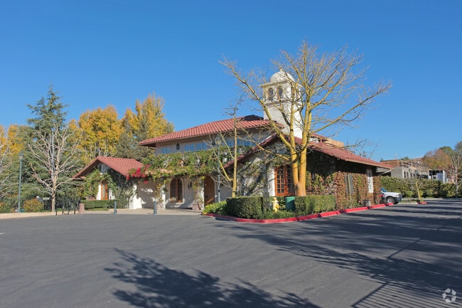
Property Detail
2001 E Thousand Oaks Blvd
Oxnard-Thousand Oaks-Ventura, CA
REF: 8 MR 73
670-0-280-170
Ventura
Commercialnec
California
B and X Area of moderate flood hazard, usually the area between the limits of the 100-year and 500-year floods.
3.86 AC
2025
Thousand Oaks/SE County
2026
Los Angeles
007100
NEARBY LISTINGS FOR SALE OR LEASE
DEMOGRAPHICS near 2001 E Thousand Oaks Blvd
1 mile
3 mile
5 mile
2025 Total Population
9,437
64,810
139,017
2030 Population
9,415
64,476
138,045
Pop Growth 2025-2030
(0.23%)
(0.52%)
(0.70%)
Average Age
41
44
44
2025 Total Households
3,838
25,048
51,526
HH Growth 2025-2030
(0.31%)
(0.62%)
(0.82%)
Median Household Inc
$84,625
$124,506
$141,710
Avg Household Size
2.40
2.50
2.60
2025 Avg HH Vehicles
2.00
2.00
2.00
Median Home Value
$793,262
$1,024,605
$1,030,235
Median Year Built
1978
1975
1978
Nearby Places
Map Layers
Map Styles
 Street
 Aerial
Layers
 Traffic
 Biking
Places
Listings with unknown addresses are not visible on the map
- Restaurants
- Banks
- Shops
- Fitness
- Groceries
PUBLIC TRANSPORTATION
AIRPORT
Bob Hope
Drive
Walk
Distance
Bob Hope
44 min
33.4 mi
Los Angeles International
Drive
Walk
Distance
Los Angeles International
54 min
41.5 mi
Freight Ports
The Port of Hueneme
Drive
Walk
Distance
The Port of Hueneme
35 min
23.8 mi
Nearby Properties
Address
Land Use
TOTAL SIZE
Lot Size
Zoning
Address
Land Use
TOTAL SIZE
Lot Size
Zoning
13.12 AC
PL
Address
Land Use
TOTAL SIZE
Lot Size
Zoning
384,742 SF
19.93 AC
RPD2
Address
Land Use
TOTAL SIZE
Lot Size
Zoning
38,851 SF
40.49 AC
M-1
Address
Land Use
TOTAL SIZE
Lot Size
Zoning
239,224 SF
11.65 AC
Address
Land Use
TOTAL SIZE
Lot Size
Zoning
253,686 SF
13.69 AC
RPD2
Address
Land Use
TOTAL SIZE
Lot Size
Zoning
233,391 SF
11.71 AC
RPD2
Address
Land Use
TOTAL SIZE
Lot Size
Zoning
Address
Land Use
TOTAL SIZE
Lot Size
Zoning
15,596 SF
3.17 AC
C2
Address
Land Use
TOTAL SIZE
Lot Size
Zoning
199,586 SF
8.95 AC
RPD25
Address
Land Use
TOTAL SIZE
Lot Size
Zoning
206,886 SF
12.11 AC
Address
Land Use
TOTAL SIZE
Lot Size
Zoning
17,278 SF
15.46 AC
Address
Land Use
TOTAL SIZE
Lot Size
Zoning
182,756 SF
8.88 AC
RPD1
Address
Land Use
TOTAL SIZE
Lot Size
Zoning
90,194 SF
4.12 AC
Address
Land Use
TOTAL SIZE
Lot Size
Zoning
26,654 SF
17.84 AC
C3
Address
Land Use
TOTAL SIZE
Lot Size
Zoning
162,078 SF
9.05 AC
R3
Address
Land Use
TOTAL SIZE
Lot Size
Zoning
10.63 AC
C4
Address
Land Use
TOTAL SIZE
Lot Size
Zoning
168,729 SF
10.21 AC
WVM1*
Address
Land Use
TOTAL SIZE
Lot Size
Zoning
2,398 SF
11.59 AC
C2
Address
Land Use
TOTAL SIZE
Lot Size
Zoning
123,248 SF
8.70 AC
RPD2
Address
Land Use
TOTAL SIZE
Lot Size
Zoning
177,503 SF
5.36 AC
Address
Land Use
TOTAL SIZE
Lot Size
Zoning
117,172 SF
14.47 AC
C1
Address
Land Use
TOTAL SIZE
Lot Size
Zoning
127,196 SF
10.18 AC
MULT
Address
Land Use
TOTAL SIZE
Lot Size
Zoning
6,606 SF
5.42 AC
M1
Address
Land Use
TOTAL SIZE
Lot Size
Zoning
73,421 SF
2.66 AC
C2
Address
Land Use
TOTAL SIZE
Lot Size
Zoning
365,098 SF
18.18 AC
WVM1*
Address
Land Use
TOTAL SIZE
Lot Size
Zoning
42,203 SF
16.37 AC
CHEVRON TE
Address
Land Use
TOTAL SIZE
Lot Size
Zoning
94,268 SF
0.81 AC
Address
Land Use
TOTAL SIZE
Lot Size
Zoning
89,664 SF
5.03 AC
R-3
Address
Land Use
TOTAL SIZE
Lot Size
Zoning
73,565 SF
5.27 AC
MULT
Address
Land Use
TOTAL SIZE
Lot Size
Zoning
21,878 SF
8.22 AC
C4
The World's #1 Commercial Real Estate Marketplace
Connect with us
© 2026 CoStar Group
The information above has been obtained from sources believed reliable. While we do not doubt its accuracy we have not verified it and make no guarantee, warranty or representation about it. It is your responsibility to independently confirm its accuracy and completeness. Any projections, opinions, assumptions, or estimates used are for example only and do not represent the current or future performance of the property. The value of this transaction to you depends on tax and other factors which should be evaluated by your tax, financial, and legal advisors. You and your advisors should conduct a careful, independent investigation of the property to determine to your satisfaction the suitability of the property for your needs.