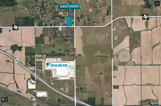
Property Record
20015 Fm 2920, Waller, TX 77484

Property Detail
20015 Fm 2920
Houston-Pasadena-The Woodlands, TX
TR 16 ABST 332 H C SCHOOL LANDS 6
0422420000043
HARRIS
Agriculturalland
Texas
B and X Area of moderate flood hazard, usually the area between the limits of the 100-year and 500-year floods.
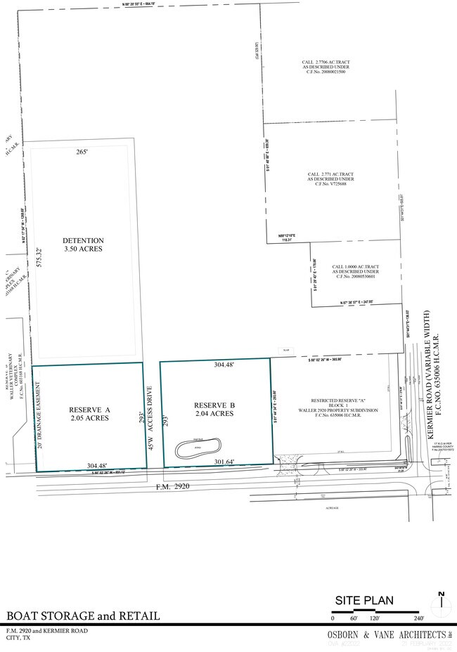
20.74 AC
2024
Northwest Outlier
2025
Houston
556000
NEARBY LISTINGS FOR SALE OR LEASE
DEMOGRAPHICS near 20015 Fm 2920
1 mile
3 mile
5 mile
2025 Total Population
390
2,279
19,406
2030 Population
397
2,416
21,541
Pop Growth 2025-2030
+ 1.79%
+ 6.01%
+ 11.00%
Average Age
38
37
35
2025 Total Households
138
776
6,328
HH Growth 2025-2030
+ 2.17%
+ 5.93%
+ 11.08%
Median Household Inc
$64,687
$87,704
$92,350
Avg Household Size
2.90
2.90
3.10
2025 Avg HH Vehicles
3.00
3.00
2.00
Median Home Value
$287,499
$327,884
$286,636
Median Year Built
1997
1999
2007
Nearby Places
Map Layers
Map Styles
 Street
 Aerial
Layers
 Traffic
 Biking
Places
Listings with unknown addresses are not visible on the map
- Restaurants
- Banks
- Shops
- Fitness
- Groceries
SALE & LEASE HISTORY
LISTING DATE
SALE/LEASE

Feb 02, 2022
For Sale
Nearby Properties
Address
Land Use
TOTAL SIZE
Lot Size
Zoning
Address
Land Use
TOTAL SIZE
Lot Size
Zoning
283.61 AC
Address
Land Use
TOTAL SIZE
Lot Size
Zoning
463,544 SF
31.14 AC
Address
Land Use
TOTAL SIZE
Lot Size
Zoning
82,217 SF
270.54 AC
Address
Land Use
TOTAL SIZE
Lot Size
Zoning
1,463.22 AC
Address
Land Use
TOTAL SIZE
Lot Size
Zoning
474.77 AC
Address
Land Use
TOTAL SIZE
Lot Size
Zoning
100,709 SF
33.32 AC
Address
Land Use
TOTAL SIZE
Lot Size
Zoning
164.11 AC
Address
Land Use
TOTAL SIZE
Lot Size
Zoning
17,400 SF
21.16 AC
Address
Land Use
TOTAL SIZE
Lot Size
Zoning
77,880 SF
20 AC
Address
Land Use
TOTAL SIZE
Lot Size
Zoning
337.84 AC
Address
Land Use
TOTAL SIZE
Lot Size
Zoning
428.29 AC
Address
Land Use
TOTAL SIZE
Lot Size
Zoning
283.44 AC
Address
Land Use
TOTAL SIZE
Lot Size
Zoning
81,900 SF
25.81 AC
Address
Land Use
TOTAL SIZE
Lot Size
Zoning
69,623 SF
10 AC
Address
Land Use
TOTAL SIZE
Lot Size
Zoning
860.08 AC
Address
Land Use
TOTAL SIZE
Lot Size
Zoning
42,400 SF
19.73 AC
Address
Land Use
TOTAL SIZE
Lot Size
Zoning
Address
Land Use
TOTAL SIZE
Lot Size
Zoning
105 AC
Address
Land Use
TOTAL SIZE
Lot Size
Zoning
467.86 AC
Address
Land Use
TOTAL SIZE
Lot Size
Zoning
30,748 SF
17.20 AC
Address
Land Use
TOTAL SIZE
Lot Size
Zoning
48,648 SF
2.25 AC
Address
Land Use
TOTAL SIZE
Lot Size
Zoning
68.28 AC
Address
Land Use
TOTAL SIZE
Lot Size
Zoning
120.20 AC
Address
Land Use
TOTAL SIZE
Lot Size
Zoning
152.84 AC
Address
Land Use
TOTAL SIZE
Lot Size
Zoning
127.53 AC
Address
Land Use
TOTAL SIZE
Lot Size
Zoning
8,827 SF
8.45 AC
Address
Land Use
TOTAL SIZE
Lot Size
Zoning
101.59 AC
Address
Land Use
TOTAL SIZE
Lot Size
Zoning
69,560 SF
13.54 AC
Address
Land Use
TOTAL SIZE
Lot Size
Zoning
81.91 AC
Address
Land Use
TOTAL SIZE
Lot Size
Zoning
208.88 AC
The World's #1 Commercial Real Estate Marketplace
Connect with us
© 2026 CoStar Group
The information above has been obtained from sources believed reliable. While we do not doubt its accuracy we have not verified it and make no guarantee, warranty or representation about it. It is your responsibility to independently confirm its accuracy and completeness. Any projections, opinions, assumptions, or estimates used are for example only and do not represent the current or future performance of the property. The value of this transaction to you depends on tax and other factors which should be evaluated by your tax, financial, and legal advisors. You and your advisors should conduct a careful, independent investigation of the property to determine to your satisfaction the suitability of the property for your needs.