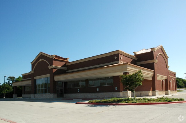
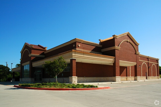
Property Record
2004 N Goliad St, Rockwall, TX 75087

Property Detail
2004 N Goliad St
Dallas-Fort Worth-Arlington, TX
QUAIL RUN RETAIL, BLOCK B, LOT 1R, ACRES 2.519, (REPLAT 2004)
54374
Rockwall
Commercialnec
Texas
B and X Area of moderate flood hazard, usually the area between the limits of the 100-year and 500-year floods.
1r
2025
2.52 AC
2025
Rockwall
040202
Dallas/Ft Worth
14,732 SF
NEARBY LISTINGS FOR SALE OR LEASE
DEMOGRAPHICS near 2004 N Goliad St
1 mile
3 mile
5 mile
2025 Total Population
11,919
35,779
121,593
2030 Population
14,210
42,757
141,426
Pop Growth 2025-2030
+ 19.22%
+ 19.50%
+ 16.31%
Average Age
38
39
38
2025 Total Households
3,776
12,412
40,738
HH Growth 2025-2030
+ 19.04%
+ 19.38%
+ 16.46%
Median Household Inc
$136,100
$112,097
$114,669
Avg Household Size
3.10
2.80
2.90
2025 Avg HH Vehicles
2.00
2.00
2.00
Median Home Value
$445,889
$440,583
$402,220
Median Year Built
2007
2005
2005
Nearby Places
Map Layers
Map Styles
 Street
 Aerial
Layers
 Traffic
 Biking
Places
Listings with unknown addresses are not visible on the map
- Restaurants
- Banks
- Shops
- Fitness
- Groceries
PUBLIC TRANSPORTATION
AIRPORT
Dallas Love Field
Drive
Walk
Distance
Dallas Love Field
46 min
30.1 mi
Freight Ports
Port of Shreveport
Drive
Walk
Distance
Port of Shreveport
209 min
186.6 mi
Nearby Properties
Address
Land Use
TOTAL SIZE
Lot Size
Zoning
Address
Land Use
TOTAL SIZE
Lot Size
Zoning
193,393 SF
69.53 AC
Address
Land Use
TOTAL SIZE
Lot Size
Zoning
288,677 SF
41.65 AC
P11
Address
Land Use
TOTAL SIZE
Lot Size
Zoning
242,845 SF
16.01 AC
Address
Land Use
TOTAL SIZE
Lot Size
Zoning
126,341 SF
18.41 AC
L1
Address
Land Use
TOTAL SIZE
Lot Size
Zoning
211,790 SF
11.58 AC
MF1
Address
Land Use
TOTAL SIZE
Lot Size
Zoning
245,501 SF
6.65 AC
Address
Land Use
TOTAL SIZE
Lot Size
Zoning
353,525 SF
42.99 AC
Address
Land Use
TOTAL SIZE
Lot Size
Zoning
191,568 SF
10.31 AC
Address
Land Use
TOTAL SIZE
Lot Size
Zoning
223,664 SF
3.80 AC
Address
Land Use
TOTAL SIZE
Lot Size
Zoning
101,024 SF
8.46 AC
Address
Land Use
TOTAL SIZE
Lot Size
Zoning
253,274 SF
18.76 AC
Address
Land Use
TOTAL SIZE
Lot Size
Zoning
121,766 SF
4.28 AC
Address
Land Use
TOTAL SIZE
Lot Size
Zoning
91,612 SF
12 AC
Address
Land Use
TOTAL SIZE
Lot Size
Zoning
146,730 SF
7.33 AC
Address
Land Use
TOTAL SIZE
Lot Size
Zoning
211,211 SF
10.19 AC
L1
Address
Land Use
TOTAL SIZE
Lot Size
Zoning
139,917 SF
8.91 AC
Address
Land Use
TOTAL SIZE
Lot Size
Zoning
213,280 SF
15.31 AC
Address
Land Use
TOTAL SIZE
Lot Size
Zoning
42,023 SF
4.19 AC
Address
Land Use
TOTAL SIZE
Lot Size
Zoning
120,525 SF
6.64 AC
Address
Land Use
TOTAL SIZE
Lot Size
Zoning
93,932 SF
11 AC
Address
Land Use
TOTAL SIZE
Lot Size
Zoning
56,652 SF
11.26 AC
Address
Land Use
TOTAL SIZE
Lot Size
Zoning
79,228 SF
14.75 AC
Address
Land Use
TOTAL SIZE
Lot Size
Zoning
90,751 SF
11.24 AC
Address
Land Use
TOTAL SIZE
Lot Size
Zoning
65,303 SF
9.43 AC
Address
Land Use
TOTAL SIZE
Lot Size
Zoning
52,051 SF
6.98 AC
Address
Land Use
TOTAL SIZE
Lot Size
Zoning
74,900 SF
15.09 AC
Address
Land Use
TOTAL SIZE
Lot Size
Zoning
227.41 AC
PD3
Address
Land Use
TOTAL SIZE
Lot Size
Zoning
57,082 SF
13.37 AC
Address
Land Use
TOTAL SIZE
Lot Size
Zoning
52,582 SF
15.16 AC
Address
Land Use
TOTAL SIZE
Lot Size
Zoning
75,600 SF
5.13 AC
The World's #1 Commercial Real Estate Marketplace
Connect with us
© 2026 CoStar Group
The information above has been obtained from sources believed reliable. While we do not doubt its accuracy we have not verified it and make no guarantee, warranty or representation about it. It is your responsibility to independently confirm its accuracy and completeness. Any projections, opinions, assumptions, or estimates used are for example only and do not represent the current or future performance of the property. The value of this transaction to you depends on tax and other factors which should be evaluated by your tax, financial, and legal advisors. You and your advisors should conduct a careful, independent investigation of the property to determine to your satisfaction the suitability of the property for your needs.