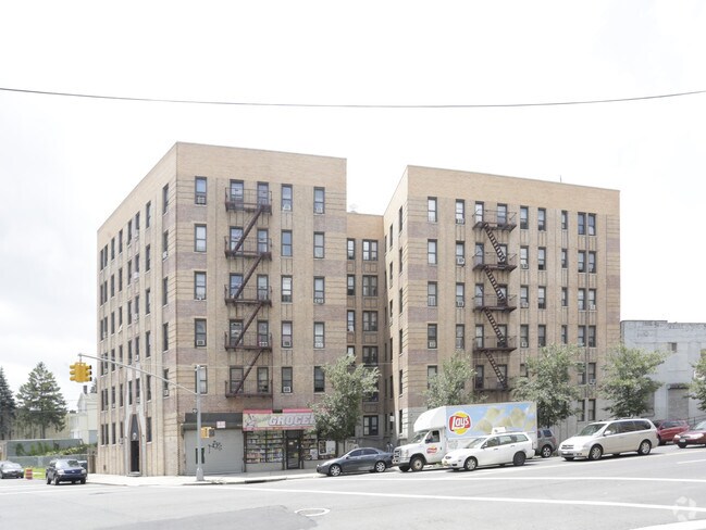
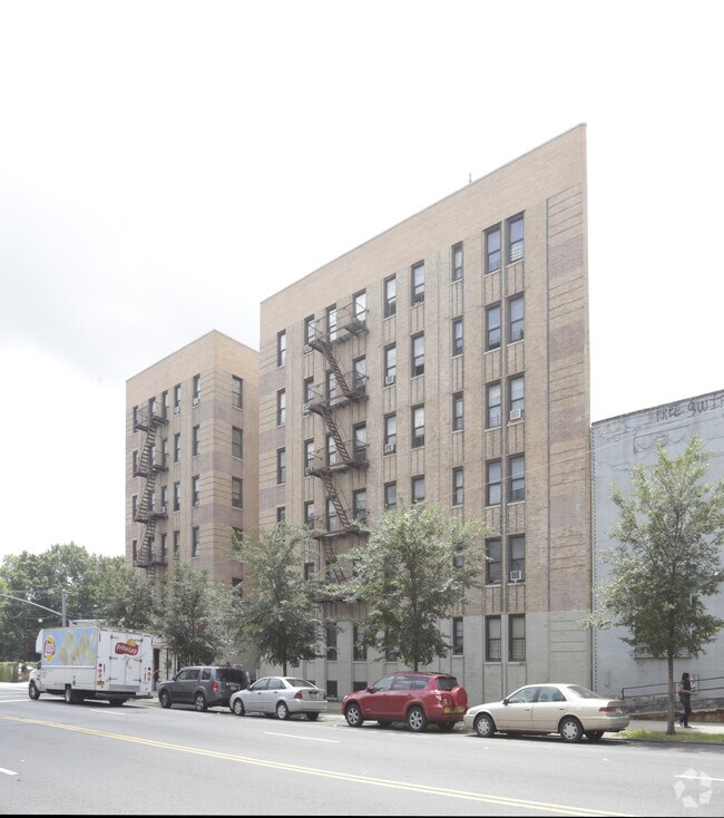
Property Record
2009 Cruger Ave, Bronx, NY 10462

NEARBY LISTINGS FOR SALE OR LEASE
Property Detail
2009 Cruger Ave
04257-0040
DOCID-2023091500916001
Apartment
Bronx
X
New York
3604970101F
40
2024
0.24 AC
2025
Van Nest
023000
Westchester/So Connecticut
49,260 SF
New York-Jersey City-White Plains, NY-NJ
DEMOGRAPHICS near 2009 Cruger Ave
1 mile
3 mile
5 mile
2024 Total Population
113,446
1,070,163
1,788,930
2029 Population
103,846
987,231
1,657,150
Pop Growth 2024-2029
(8.46%)
(7.75%)
(7.37%)
Average Age
38
38
39
2024 Total Households
41,895
373,580
649,046
HH Growth 2024-2029
(9.20%)
(8.50%)
(7.94%)
Median Household Inc
$48,522
$42,356
$46,148
Avg Household Size
2.60
2.70
2.60
2024 Avg HH Vehicles
1.00
.00
1.00
Median Home Value
$578,302
$493,067
$529,507
Median Year Built
1948
1952
1951
Nearby Places
Map Layers
Map Styles
 Street
 Aerial
Transit
 Traffic
 Biking
Places
Listings with unknown addresses are not visible on the map
- Restaurants
- Banks
- Shops
- Fitness
- Groceries
PUBLIC TRANSPORTATION
TRANSIT/SUBWAY
Bronx Park East (2 - New York MTA Subway (The Subway), 5 - New York MTA Subway (The Subway))
Drive
Walk
Distance
Bronx Park East (2 - New York MTA Subway (The Subway), 5 - New York MTA Subway (The Subway))
0 min
4 min
0.2 mi
Pelham Parkway (2,5 Line) (2 - New York MTA Subway (The Subway), 5 - New York MTA Subway (The Subway))
Drive
Walk
Distance
Pelham Parkway (2,5 Line) (2 - New York MTA Subway (The Subway), 5 - New York MTA Subway (The Subway))
1 min
9 min
0.5 mi
Morris Park (5 - New York MTA Subway (The Subway))
Drive
Walk
Distance
Morris Park (5 - New York MTA Subway (The Subway))
2 min
12 min
0.6 mi
East 180 Street (2 - New York MTA Subway (The Subway), 5 - New York MTA Subway (The Subway))
Drive
Walk
Distance
East 180 Street (2 - New York MTA Subway (The Subway), 5 - New York MTA Subway (The Subway))
2 min
17 min
0.9 mi
Pelham Parkway (5 Line) (5 - New York MTA Subway (The Subway))
Drive
Walk
Distance
Pelham Parkway (5 Line) (5 - New York MTA Subway (The Subway))
3 min
19 min
1.0 mi
COMMUTER RAIL
Fordham Station (Harlem Line - Metro-North Commuter Railroad Company (Metro-North), New Haven Line - Metro-North Commuter Railroad Company (Metro-North))
Drive
Walk
Distance
Fordham Station (Harlem Line - Metro-North Commuter Railroad Company (Metro-North), New Haven Line - Metro-North Commuter Railroad Company (Metro-North))
6 min
2.1 mi
Botanical Garden Station (Harlem Line - Metro-North Commuter Railroad Company (Metro-North))
Drive
Walk
Distance
Botanical Garden Station (Harlem Line - Metro-North Commuter Railroad Company (Metro-North))
5 min
2.1 mi
AIRPORT
LaGuardia
Drive
Walk
Distance
LaGuardia
21 min
10.4 mi
John F Kennedy International
Drive
Walk
Distance
John F Kennedy International
27 min
18.0 mi
Westchester County
Drive
Walk
Distance
Westchester County
34 min
21.7 mi
Freight Ports
NY - Red Hook Container Terminal
Drive
Walk
Distance
NY - Red Hook Container Terminal
34 min
18.9 mi
Nearby Properties
Address
Land Use
TOTAL SIZE
Lot Size
Zoning
Address
Land Use
TOTAL SIZE
Lot Size
Zoning
115.90 AC
R6
Address
Land Use
TOTAL SIZE
Lot Size
Zoning
115.90 AC
R6
Address
Land Use
TOTAL SIZE
Lot Size
Zoning
115.90 AC
R6
Address
Land Use
TOTAL SIZE
Lot Size
Zoning
115.90 AC
R6
Address
Land Use
TOTAL SIZE
Lot Size
Zoning
115.90 AC
R6
Address
Land Use
TOTAL SIZE
Lot Size
Zoning
115.90 AC
R6
Address
Land Use
TOTAL SIZE
Lot Size
Zoning
115.90 AC
R6
Address
Land Use
TOTAL SIZE
Lot Size
Zoning
115.90 AC
R6
Address
Land Use
TOTAL SIZE
Lot Size
Zoning
115.90 AC
R6
Address
Land Use
TOTAL SIZE
Lot Size
Zoning
115.90 AC
R6
Address
Land Use
TOTAL SIZE
Lot Size
Zoning
115.90 AC
R6
Address
Land Use
TOTAL SIZE
Lot Size
Zoning
115.90 AC
R6
Address
Land Use
TOTAL SIZE
Lot Size
Zoning
115.90 AC
R6
Address
Land Use
TOTAL SIZE
Lot Size
Zoning
115.90 AC
R6
Address
Land Use
TOTAL SIZE
Lot Size
Zoning
115.90 AC
R6
Address
Land Use
TOTAL SIZE
Lot Size
Zoning
115.90 AC
R6
Address
Land Use
TOTAL SIZE
Lot Size
Zoning
115.90 AC
R6
Address
Land Use
TOTAL SIZE
Lot Size
Zoning
115.90 AC
R6
Address
Land Use
TOTAL SIZE
Lot Size
Zoning
115.90 AC
R6
Address
Land Use
TOTAL SIZE
Lot Size
Zoning
115.90 AC
R6
Address
Land Use
TOTAL SIZE
Lot Size
Zoning
115.90 AC
R6
Address
Land Use
TOTAL SIZE
Lot Size
Zoning
115.90 AC
R6
Address
Land Use
TOTAL SIZE
Lot Size
Zoning
115.90 AC
R6
Address
Land Use
TOTAL SIZE
Lot Size
Zoning
115.90 AC
R6
Address
Land Use
TOTAL SIZE
Lot Size
Zoning
115.90 AC
R6
Address
Land Use
TOTAL SIZE
Lot Size
Zoning
1,299,700 SF
29.82 AC
R6
Address
Land Use
TOTAL SIZE
Lot Size
Zoning
550,000 SF
8.75 AC
M1-1
Address
Land Use
TOTAL SIZE
Lot Size
Zoning
13,243,398 SF
115.90 AC
R6
Address
Land Use
TOTAL SIZE
Lot Size
Zoning
1,743,584 SF
77.87 AC
R6
Address
Land Use
TOTAL SIZE
Lot Size
Zoning
44.83 AC
R6
The World's #1 Commercial Real Estate Marketplace
Connect with us
© 2026 CoStar Group
The information above has been obtained from sources believed reliable. While we do not doubt its accuracy we have not verified it and make no guarantee, warranty or representation about it. It is your responsibility to independently confirm its accuracy and completeness. Any projections, opinions, assumptions, or estimates used are for example only and do not represent the current or future performance of the property. The value of this transaction to you depends on tax and other factors which should be evaluated by your tax, financial, and legal advisors. You and your advisors should conduct a careful, independent investigation of the property to determine to your satisfaction the suitability of the property for your needs.