Property Record
201 Bluffs Ct, Canton, GA 30114


Save to a Folder
{{folder.Name}}
{{folder.ListingIds.length}} Properties
{{folder.ListingIds.length}} Property
Create a New Folder
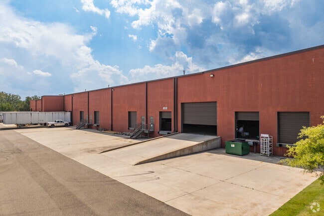
Property Detail
201 Bluffs Ct
014N22-00000-006-00Q-0000
LL 224, 225, 244 14TH D
Lightindustrial
CHEROKEE
PD-MU
Georgia
B and X Area of moderate flood hazard, usually the area between the limits of the 100-year and 500-year floods.
9.63 AC
2025
Woodstock/Canton
2025
Atlanta
090402
Atlanta-Sandy Springs-Roswell, GA
82,621 SF
NEARBY LISTINGS FOR SALE OR LEASE
DEMOGRAPHICS near 201 Bluffs Ct
1 mile
3 mile
5 mile
2025 Total Population
2,254
19,683
42,157
2030 Population
2,540
21,804
46,054
Pop Growth 2025-2030
+ 12.69%
+ 10.78%
+ 9.24%
Average Age
41
40
41
2025 Total Households
791
7,318
15,278
HH Growth 2025-2030
+ 12.77%
+ 10.80%
+ 9.38%
Median Household Inc
$110,565
$79,300
$88,147
Avg Household Size
2.90
2.60
2.70
2025 Avg HH Vehicles
2.00
2.00
2.00
Median Home Value
$589,789
$481,779
$478,443
Median Year Built
2010
2005
2002
Nearby Places
Map Layers
Map Styles
 Street
 Aerial
Layers
 Traffic
 Biking
Places
Listings with unknown addresses are not visible on the map
- Restaurants
- Banks
- Shops
- Fitness
- Groceries
SALE & LEASE HISTORY
LISTING DATE
SALE/LEASE

Mar 07, 2022
For Lease
Nearby Properties
Address
Land Use
TOTAL SIZE
Lot Size
Zoning
Address
Land Use
TOTAL SIZE
Lot Size
Zoning
299,432 SF
50.55 AC
PD-MU
Address
Land Use
TOTAL SIZE
Lot Size
Zoning
244,451 SF
20.55 AC
PSC
Address
Land Use
TOTAL SIZE
Lot Size
Zoning
260,621 SF
26.25 AC
RM-15
Address
Land Use
TOTAL SIZE
Lot Size
Zoning
133,711 SF
22.23 AC
R-3
Address
Land Use
TOTAL SIZE
Lot Size
Zoning
80,795 SF
34.86 AC
PD-MIXED U
Address
Land Use
TOTAL SIZE
Lot Size
Zoning
239,139 SF
88 AC
PD-MU
Address
Land Use
TOTAL SIZE
Lot Size
Zoning
238,343 SF
38.77 AC
PSC
Address
Land Use
TOTAL SIZE
Lot Size
Zoning
270,248 SF
29.05 AC
PD-MU
Address
Land Use
TOTAL SIZE
Lot Size
Zoning
279,274 SF
23.46 AC
R-5
Address
Land Use
TOTAL SIZE
Lot Size
Zoning
197.68 AC
PD-MU
Address
Land Use
TOTAL SIZE
Lot Size
Zoning
79,672 SF
4.28 AC
PSC
Address
Land Use
TOTAL SIZE
Lot Size
Zoning
548,520 SF
70.10 AC
LI
Address
Land Use
TOTAL SIZE
Lot Size
Zoning
687,913 SF
24.31 AC
LI
Address
Land Use
TOTAL SIZE
Lot Size
Zoning
159,645 SF
14.05 AC
RM-15
Address
Land Use
TOTAL SIZE
Lot Size
Zoning
78,236 SF
23.64 AC
PD
Address
Land Use
TOTAL SIZE
Lot Size
Zoning
66,710 SF
15.14 AC
PD-MU
Address
Land Use
TOTAL SIZE
Lot Size
Zoning
423,504 SF
12.95 AC
LI
Address
Land Use
TOTAL SIZE
Lot Size
Zoning
31,822 SF
2.29 AC
PSC
Address
Land Use
TOTAL SIZE
Lot Size
Zoning
196,718 SF
32.59 AC
GC
Address
Land Use
TOTAL SIZE
Lot Size
Zoning
27,935 SF
1.82 AC
PSC
Address
Land Use
TOTAL SIZE
Lot Size
Zoning
27.16 AC
PD-MU
Address
Land Use
TOTAL SIZE
Lot Size
Zoning
58.19 AC
PD-MIXED U
Address
Land Use
TOTAL SIZE
Lot Size
Zoning
63,061 SF
11.22 AC
GC
Address
Land Use
TOTAL SIZE
Lot Size
Zoning
28,109 SF
1.89 AC
PSC
Address
Land Use
TOTAL SIZE
Lot Size
Zoning
176,500 SF
7.82 AC
LI
Address
Land Use
TOTAL SIZE
Lot Size
Zoning
62,108 SF
25 AC
OI
Address
Land Use
TOTAL SIZE
Lot Size
Zoning
108,892 SF
16.53 AC
LI
Address
Land Use
TOTAL SIZE
Lot Size
Zoning
32,367 SF
3.80 AC
PSC
Address
Land Use
TOTAL SIZE
Lot Size
Zoning
52,553 SF
8.35 AC
LI
The World's #1 Commercial Real Estate Marketplace
Connect with us
© 2026 CoStar Group
The information above has been obtained from sources believed reliable. While we do not doubt its accuracy we have not verified it and make no guarantee, warranty or representation about it. It is your responsibility to independently confirm its accuracy and completeness. Any projections, opinions, assumptions, or estimates used are for example only and do not represent the current or future performance of the property. The value of this transaction to you depends on tax and other factors which should be evaluated by your tax, financial, and legal advisors. You and your advisors should conduct a careful, independent investigation of the property to determine to your satisfaction the suitability of the property for your needs.