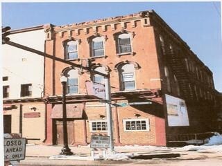
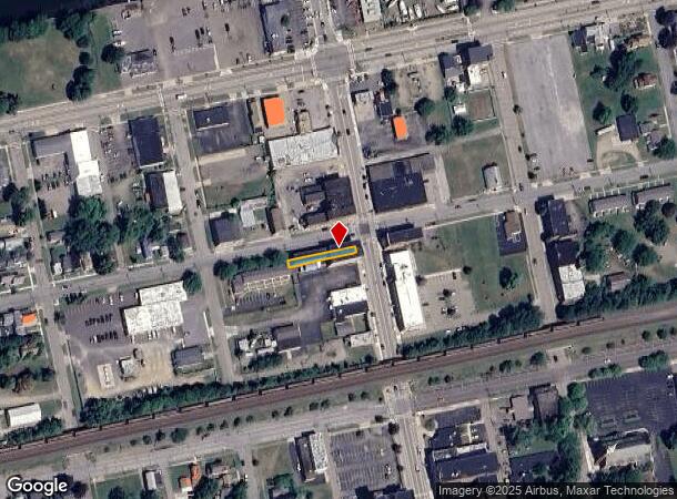
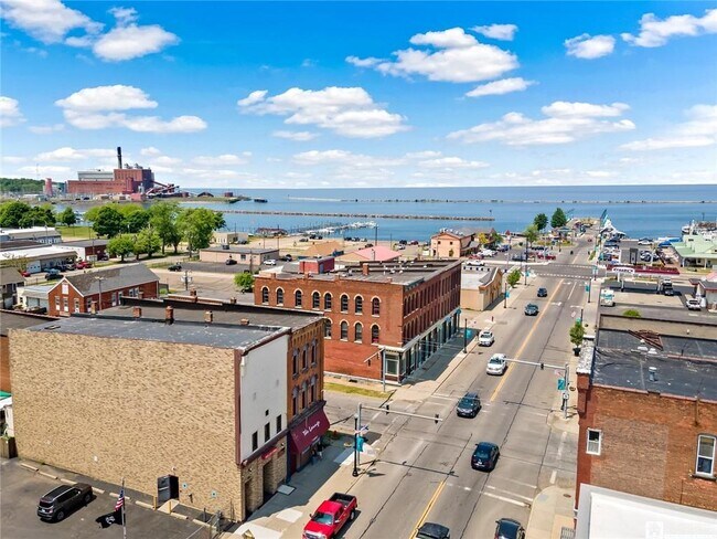
Property Record
201 Central Ave, Dunkirk, NY 14048
NEARBY LISTINGS FOR SALE OR LEASE
Property Detail
201 Central Ave
Jamestown-Dunkirk, NY
22 X 180 MER; OLD APN: 060300 11-5-1
060300-079-014-0004-013-000
Chautauqua
Commercialofficeresidentialmixeduse
New York
2025
13.000
2024
0.09 AC
035600
New York West Area
12,312 SF
Other Market Areas
DEMOGRAPHICS near 201 Central Ave
1 mile
3 mile
5 mile
2024 Total Population
8,209
18,452
25,412
2029 Population
7,915
18,016
24,931
Pop Growth 2024-2029
(3.58%)
(2.36%)
(1.89%)
Average Age
40
39
41
2024 Total Households
3,450
7,157
10,192
HH Growth 2024-2029
(3.77%)
(2.58%)
(2.02%)
Median Household Inc
$32,538
$42,710
$44,201
Avg Household Size
2.20
2.20
2.20
2024 Avg HH Vehicles
1.00
1.00
2.00
Median Home Value
$62,544
$84,516
$103,814
Median Year Built
1948
1949
1949
Nearby Places
Map Layers
Map Styles
 Street
 Aerial
Transit
 Traffic
 Biking
Places
Listings with unknown addresses are not visible on the map
- Restaurants
- Banks
- Shops
- Fitness
- Groceries
SALE & LEASE HISTORY
LISTING DATE
SALE/LEASE

Oct 10, 2016
For Sale
Jun 30, 2023
For Sale
Nearby Properties
Address
Land Use
TOTAL SIZE
Lot Size
Zoning
Address
Land Use
TOTAL SIZE
Lot Size
Zoning
Address
Land Use
TOTAL SIZE
Lot Size
Zoning
135,304 SF
4.96 AC
CBD
Address
Land Use
TOTAL SIZE
Lot Size
Zoning
83.12 AC
Address
Land Use
TOTAL SIZE
Lot Size
Zoning
163,219 SF
6.50 AC
M2
Address
Land Use
TOTAL SIZE
Lot Size
Zoning
836 SF
22 AC
R2
Address
Land Use
TOTAL SIZE
Lot Size
Zoning
1,300 SF
16 AC
M1
Address
Land Use
TOTAL SIZE
Lot Size
Zoning
542,989 SF
47.40 AC
L1
Address
Land Use
TOTAL SIZE
Lot Size
Zoning
153,111 SF
12.70 AC
R2
Address
Land Use
TOTAL SIZE
Lot Size
Zoning
15,244 SF
19.36 AC
M2
Address
Land Use
TOTAL SIZE
Lot Size
Zoning
99,596 SF
17.13 AC
AG
Address
Land Use
TOTAL SIZE
Lot Size
Zoning
113,097 SF
8.20 AC
HC
Address
Land Use
TOTAL SIZE
Lot Size
Zoning
31.20 AC
C1
Address
Land Use
TOTAL SIZE
Lot Size
Zoning
90,660 SF
5.30 AC
HC
Address
Land Use
TOTAL SIZE
Lot Size
Zoning
99,617 SF
4.96 AC
R2
Address
Land Use
TOTAL SIZE
Lot Size
Zoning
21,000 SF
11.70 AC
HC
Address
Land Use
TOTAL SIZE
Lot Size
Zoning
2.11 AC
CBD
Address
Land Use
TOTAL SIZE
Lot Size
Zoning
143,375 SF
24.70 AC
C2
Address
Land Use
TOTAL SIZE
Lot Size
Zoning
228,261 SF
10.50 AC
L1
Address
Land Use
TOTAL SIZE
Lot Size
Zoning
10,000 SF
1.10 AC
C2
Address
Land Use
TOTAL SIZE
Lot Size
Zoning
85,175 SF
5.40 AC
C1
Address
Land Use
TOTAL SIZE
Lot Size
Zoning
29.90 AC
07 - MIXED
Address
Land Use
TOTAL SIZE
Lot Size
Zoning
21.70 AC
07 - MIXED
Address
Land Use
TOTAL SIZE
Lot Size
Zoning
4,988 SF
12.90 AC
R1
Address
Land Use
TOTAL SIZE
Lot Size
Zoning
69,093 SF
1.90 AC
C1
Address
Land Use
TOTAL SIZE
Lot Size
Zoning
49,310 SF
3.80 AC
C1
Address
Land Use
TOTAL SIZE
Lot Size
Zoning
33,826 SF
3.10 AC
R3
Address
Land Use
TOTAL SIZE
Lot Size
Zoning
20,800 SF
11.20 AC
R1
Address
Land Use
TOTAL SIZE
Lot Size
Zoning
30,882 SF
10.58 AC
M2
Address
Land Use
TOTAL SIZE
Lot Size
Zoning
31,715 SF
3.20 AC
CR
Address
Land Use
TOTAL SIZE
Lot Size
Zoning
20.60 AC
CR
The World's #1 Commercial Real Estate Marketplace
Connect with us
© 2026 CoStar Group
The information above has been obtained from sources believed reliable. While we do not doubt its accuracy we have not verified it and make no guarantee, warranty or representation about it. It is your responsibility to independently confirm its accuracy and completeness. Any projections, opinions, assumptions, or estimates used are for example only and do not represent the current or future performance of the property. The value of this transaction to you depends on tax and other factors which should be evaluated by your tax, financial, and legal advisors. You and your advisors should conduct a careful, independent investigation of the property to determine to your satisfaction the suitability of the property for your needs.