Property Record
201 Murray St, Niwot, CO 80544
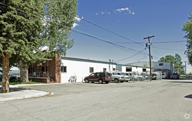

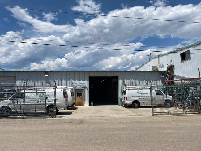

Property Detail
201 Murray St
1317254-00-005
0.57 ACS M/L IN NW 1/4 SE 1/4 25-2N-70
Warehouse
BOULDER
RC
Colorado
B and X Area of moderate flood hazard, usually the area between the limits of the 100-year and 500-year floods.
0.56 AC
2024
Boulder County
2025
Denver
013205
Boulder, CO
8,465 SF
NEARBY LISTINGS FOR SALE OR LEASE
DEMOGRAPHICS near 201 Murray St
1 mile
3 mile
5 mile
2024 Total Population
2,618
19,470
46,881
2029 Population
2,624
19,372
46,753
Pop Growth 2024-2029
+ 0.23%
(0.50%)
(0.27%)
Average Age
47
43
42
2024 Total Households
1,062
7,870
18,860
HH Growth 2024-2029
+ 0.09%
(0.89%)
(0.46%)
Median Household Inc
$142,931
$139,899
$114,392
Avg Household Size
2.30
2.40
2.40
2024 Avg HH Vehicles
2.00
2.00
2.00
Median Home Value
$935,883
$856,672
$793,184
Median Year Built
1983
1996
1992
Nearby Places
Map Layers
Map Styles
 Street
 Aerial
Transit
 Traffic
 Biking
Places
Listings with unknown addresses are not visible on the map
- Restaurants
- Banks
- Shops
- Fitness
- Groceries
PUBLIC TRANSPORTATION
AIRPORT
Denver International
Drive
Walk
Distance
Denver International
56 min
43.0 mi
SALE & LEASE HISTORY
LISTING DATE
SALE/LEASE

Jul 15, 2020
For Lease
Nearby Properties
Address
Land Use
TOTAL SIZE
Lot Size
Zoning
Address
Land Use
TOTAL SIZE
Lot Size
Zoning
17.51 AC
Address
Land Use
TOTAL SIZE
Lot Size
Zoning
155.96 AC
Address
Land Use
TOTAL SIZE
Lot Size
Zoning
141.82 AC
A
Address
Land Use
TOTAL SIZE
Lot Size
Zoning
2,696,002 SF
344.44 AC
Address
Land Use
TOTAL SIZE
Lot Size
Zoning
97.48 AC
A
Address
Land Use
TOTAL SIZE
Lot Size
Zoning
621 SF
118.25 AC
A
Address
Land Use
TOTAL SIZE
Lot Size
Zoning
174.57 AC
A
Address
Land Use
TOTAL SIZE
Lot Size
Zoning
173.50 AC
A
Address
Land Use
TOTAL SIZE
Lot Size
Zoning
306.20 AC
A
Address
Land Use
TOTAL SIZE
Lot Size
Zoning
4,048 SF
158.20 AC
A
Address
Land Use
TOTAL SIZE
Lot Size
Zoning
147.13 AC
A
Address
Land Use
TOTAL SIZE
Lot Size
Zoning
161.08 AC
A
Address
Land Use
TOTAL SIZE
Lot Size
Zoning
158.19 AC
A
Address
Land Use
TOTAL SIZE
Lot Size
Zoning
159.19 AC
A
Address
Land Use
TOTAL SIZE
Lot Size
Zoning
223,669 SF
14.27 AC
Address
Land Use
TOTAL SIZE
Lot Size
Zoning
304,116 SF
23.66 AC
MF
Address
Land Use
TOTAL SIZE
Lot Size
Zoning
56,673 SF
35.16 AC
A
Address
Land Use
TOTAL SIZE
Lot Size
Zoning
34.29 AC
A
Address
Land Use
TOTAL SIZE
Lot Size
Zoning
267.15 AC
RR
Address
Land Use
TOTAL SIZE
Lot Size
Zoning
33.28 AC
A
Address
Land Use
TOTAL SIZE
Lot Size
Zoning
1,072,030 SF
119.89 AC
Address
Land Use
TOTAL SIZE
Lot Size
Zoning
80.83 AC
A
Address
Land Use
TOTAL SIZE
Lot Size
Zoning
79.23 AC
A
Address
Land Use
TOTAL SIZE
Lot Size
Zoning
79.45 AC
A
Address
Land Use
TOTAL SIZE
Lot Size
Zoning
76.35 AC
A
Address
Land Use
TOTAL SIZE
Lot Size
Zoning
76.33 AC
A
Address
Land Use
TOTAL SIZE
Lot Size
Zoning
74.26 AC
A
Address
Land Use
TOTAL SIZE
Lot Size
Zoning
73.97 AC
Address
Land Use
TOTAL SIZE
Lot Size
Zoning
33.11 AC
A
Address
Land Use
TOTAL SIZE
Lot Size
Zoning
1,344 SF
141.01 AC
The World's #1 Commercial Real Estate Marketplace
Connect with us
© 2026 CoStar Group
The information above has been obtained from sources believed reliable. While we do not doubt its accuracy we have not verified it and make no guarantee, warranty or representation about it. It is your responsibility to independently confirm its accuracy and completeness. Any projections, opinions, assumptions, or estimates used are for example only and do not represent the current or future performance of the property. The value of this transaction to you depends on tax and other factors which should be evaluated by your tax, financial, and legal advisors. You and your advisors should conduct a careful, independent investigation of the property to determine to your satisfaction the suitability of the property for your needs.