Property Record
201 State Highway 7 St, , CO
This Property Is For Sale
Property Detail
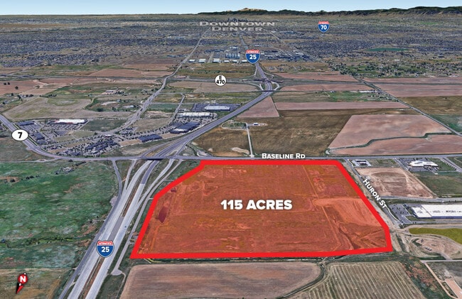
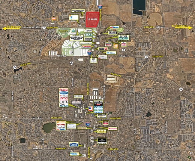
201 State Highway 7 St
Denver-Aurora-Centennial, CO
SUBD: NORTHLANDS FILING NO 1 REPLAT B LOT: 1 S: 34 T: 1N R: 68W
1467-34-4-03-004
BROOMFIELD
Residentialacreage
Colorado
PUD
1
2024
4.76 AC
2025
Broomfield County
031400
Denver
NEARBY LISTINGS FOR SALE OR LEASE
DEMOGRAPHICS near 201 State Highway 7 St
1 mile
3 mile
5 mile
2024 Total Population
2,687
25,691
94,882
2029 Population
2,957
27,695
100,447
Pop Growth 2024-2029
+ 10.05%
+ 7.80%
+ 5.87%
Average Age
34
37
39
2024 Total Households
900
8,806
32,705
HH Growth 2024-2029
+ 10.44%
+ 8.16%
+ 6.08%
Median Household Inc
$139,821
$169,571
$153,565
Avg Household Size
2.90
2.90
2.90
2024 Avg HH Vehicles
2.00
2.00
2.00
Median Home Value
$737,859
$775,280
$752,827
Median Year Built
2011
2010
2007
Nearby Places
Map Layers
Map Styles
 Street
 Aerial
Transit
 Traffic
 Biking
Places
Listings with unknown addresses are not visible on the map
- Restaurants
- Banks
- Shops
- Fitness
- Groceries
Nearby Properties
Address
Land Use
TOTAL SIZE
Lot Size
Zoning
Address
Land Use
TOTAL SIZE
Lot Size
Zoning
355,866 SF
16.17 AC
Address
Land Use
TOTAL SIZE
Lot Size
Zoning
538,595 SF
87.92 AC
Address
Land Use
TOTAL SIZE
Lot Size
Zoning
177,730 SF
17.82 AC
PUD
Address
Land Use
TOTAL SIZE
Lot Size
Zoning
712,276 SF
72.16 AC
Address
Land Use
TOTAL SIZE
Lot Size
Zoning
869,000 SF
61.97 AC
Address
Land Use
TOTAL SIZE
Lot Size
Zoning
190,387 SF
106.32 AC
PUD
Address
Land Use
TOTAL SIZE
Lot Size
Zoning
202,491 SF
52.56 AC
PUD
Address
Land Use
TOTAL SIZE
Lot Size
Zoning
333,686 SF
19.68 AC
PUD
Address
Land Use
TOTAL SIZE
Lot Size
Zoning
136,036 SF
12.87 AC
PUD
Address
Land Use
TOTAL SIZE
Lot Size
Zoning
253,459 SF
34.63 AC
Address
Land Use
TOTAL SIZE
Lot Size
Zoning
119,427 SF
12.75 AC
PUD
Address
Land Use
TOTAL SIZE
Lot Size
Zoning
284,997 SF
13.55 AC
PUD
Address
Land Use
TOTAL SIZE
Lot Size
Zoning
176,000 SF
12.03 AC
Address
Land Use
TOTAL SIZE
Lot Size
Zoning
164,372 SF
11.58 AC
PUD
Address
Land Use
TOTAL SIZE
Lot Size
Zoning
39.44 AC
PUD
Address
Land Use
TOTAL SIZE
Lot Size
Zoning
297,895 SF
6.77 AC
Address
Land Use
TOTAL SIZE
Lot Size
Zoning
146,300 SF
9 AC
Address
Land Use
TOTAL SIZE
Lot Size
Zoning
386,513 SF
4.89 AC
Address
Land Use
TOTAL SIZE
Lot Size
Zoning
130,628 SF
12.13 AC
PUD
Address
Land Use
TOTAL SIZE
Lot Size
Zoning
268,040 SF
17.59 AC
Address
Land Use
TOTAL SIZE
Lot Size
Zoning
152,841 SF
9.30 AC
PUD
Address
Land Use
TOTAL SIZE
Lot Size
Zoning
152,841 SF
7.74 AC
PUD
Address
Land Use
TOTAL SIZE
Lot Size
Zoning
152,841 SF
7.74 AC
PUD
Address
Land Use
TOTAL SIZE
Lot Size
Zoning
152,841 SF
7.74 AC
PUD
Address
Land Use
TOTAL SIZE
Lot Size
Zoning
124,446 SF
14.31 AC
Address
Land Use
TOTAL SIZE
Lot Size
Zoning
128,656 SF
6.27 AC
Address
Land Use
TOTAL SIZE
Lot Size
Zoning
112,594 SF
12.35 AC
Address
Land Use
TOTAL SIZE
Lot Size
Zoning
180,159 SF
14.93 AC
Address
Land Use
TOTAL SIZE
Lot Size
Zoning
114,700 SF
9.99 AC
Address
Land Use
TOTAL SIZE
Lot Size
Zoning
36,022 SF
2.68 AC
PUD
The World's #1 Commercial Real Estate Marketplace
Connect with us
© 2026 CoStar Group
The information above has been obtained from sources believed reliable. While we do not doubt its accuracy we have not verified it and make no guarantee, warranty or representation about it. It is your responsibility to independently confirm its accuracy and completeness. Any projections, opinions, assumptions, or estimates used are for example only and do not represent the current or future performance of the property. The value of this transaction to you depends on tax and other factors which should be evaluated by your tax, financial, and legal advisors. You and your advisors should conduct a careful, independent investigation of the property to determine to your satisfaction the suitability of the property for your needs.