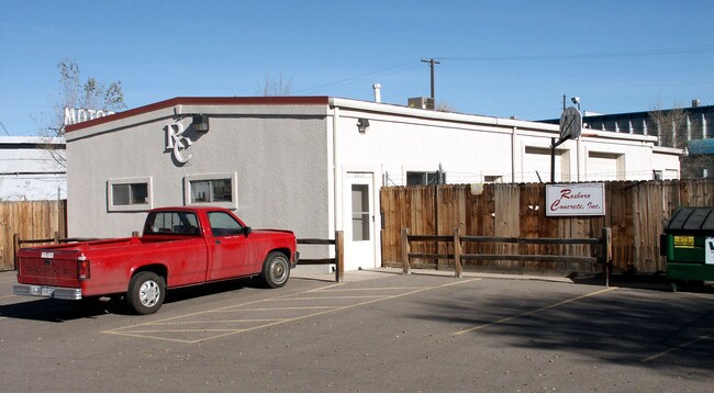
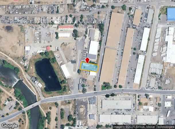
Property Record
2019 W Union Ave, Englewood, CO 80110
NEARBY LISTINGS FOR SALE OR LEASE
Property Detail
2019 W Union Ave
2077-09-2-00-025
SECTION 09 TOWNSHIP 05 RANGE 68 BEG 962.5 FT E & 254 FT S OF NW COR OF SW 1/4 NW 1/4 OF SEC 9-5-68 TH S 9 DEGREES 05 W 482.8 FT TRUE PT OF BEG TH S 80 DEGREES 55 E 180 FT TH N 9 DEGREES 05 E 76.57 FT M/L TH N 80 DEGREES 55 W 180 FT TH S 9 DEGREES 05
Warehouse
Arapahoe
X
Colorado
08005C0144L
0.32 AC
2023
Southwest C-470
2024
Denver
006200
Denver-Aurora-Lakewood, CO
1,800 SF
DEMOGRAPHICS near 2019 W Union Ave
1 Mile
3 Mile
5 Mile
2024 Total Population
7,272
105,118
304,515
2029 Population
7,320
105,576
305,291
Pop Growth 2024-2029
+ 0.66%
+ 0.44%
+ 0.25%
Average Age
40
41
40
2024 Total Households
3,229
44,840
124,840
HH Growth 2024-2029
+ 0.74%
+ 0.49%
+ 0.31%
Median Household Inc
$85,625
$76,578
$86,339
Avg Household Size
2.20
2.30
2.30
2024 Avg HH Vehicles
2.00
2.00
2.00
Median Home Value
$445,854
$496,956
$558,762
Median Year Built
1974
1970
1972
Nearby Places
Map Layers
Map Styles
 Street
 Aerial
- Restaurants
- Banks
- Shops
- Fitness
- Groceries
PUBLIC TRANSPORTATION
COMMUTER RAIL
Union Station: LoDo-Coors Field-16th Street Mall (C Line - Denver Regional Transportation District Light Rail (TheRide), E Line - Denver Regional Transportation District Light Rail (TheRide), W Line - Denver Regional Transportation District Light Rail (TheRide))
DRIVE
WALK
Distance
Union Station: LoDo-Coors Field-16th Street Mall (C Line - Denver Regional Transportation District Light Rail (TheRide), E Line - Denver Regional Transportation District Light Rail (TheRide), W Line - Denver Regional Transportation District Light Rail (TheRide))
16 min
9.7 mi
DRIVE
WALK
Distance
16 min
9.7 mi
AIRPORT
Denver International
DRIVE
WALK
Distance
Denver International
45 min
32.9 mi
Nearby Properties
Address
Land Use
TOTAL SIZE
Lot Size
Zoning
Address
Land Use
TOTAL SIZE
Lot Size
Zoning
665,722 SF
615.85 AC
OS-B
Address
Land Use
TOTAL SIZE
Lot Size
Zoning
248,291 SF
128.77 AC
CMP-H2
Address
Land Use
TOTAL SIZE
Lot Size
Zoning
330,776 SF
48.11 AC
CMP-H2
Address
Land Use
TOTAL SIZE
Lot Size
Zoning
214,192 SF
0.03 AC
Address
Land Use
TOTAL SIZE
Lot Size
Zoning
251,583 SF
38.03 AC
Address
Land Use
TOTAL SIZE
Lot Size
Zoning
381 SF
66.05 AC
I-B
Address
Land Use
TOTAL SIZE
Lot Size
Zoning
208,529 SF
34.81 AC
R-5
Address
Land Use
TOTAL SIZE
Lot Size
Zoning
33,500 SF
53.33 AC
Address
Land Use
TOTAL SIZE
Lot Size
Zoning
139,858 SF
2.36 AC
Address
Land Use
TOTAL SIZE
Lot Size
Zoning
221,025 SF
8.45 AC
PUD
Address
Land Use
TOTAL SIZE
Lot Size
Zoning
118,881 SF
107.83 AC
Address
Land Use
TOTAL SIZE
Lot Size
Zoning
107,159 SF
26.40 AC
Address
Land Use
TOTAL SIZE
Lot Size
Zoning
47.24 AC
Address
Land Use
TOTAL SIZE
Lot Size
Zoning
7,035 SF
12.90 AC
LPD-R
Address
Land Use
TOTAL SIZE
Lot Size
Zoning
110,016 SF
1.29 AC
Address
Land Use
TOTAL SIZE
Lot Size
Zoning
10,260 SF
49.33 AC
CMP-H2
Address
Land Use
TOTAL SIZE
Lot Size
Zoning
250,402 SF
21 AC
Address
Land Use
TOTAL SIZE
Lot Size
Zoning
229,830 SF
11.33 AC
Address
Land Use
TOTAL SIZE
Lot Size
Zoning
258,980 SF
16.55 AC
PUD
Address
Land Use
TOTAL SIZE
Lot Size
Zoning
206,632 SF
33.68 AC
Address
Land Use
TOTAL SIZE
Lot Size
Zoning
239,795 SF
12.56 AC
I-A
Address
Land Use
TOTAL SIZE
Lot Size
Zoning
299,772 SF
14.19 AC
Address
Land Use
TOTAL SIZE
Lot Size
Zoning
94,367 SF
10.02 AC
R-2
Address
Land Use
TOTAL SIZE
Lot Size
Zoning
39.44 AC
Address
Land Use
TOTAL SIZE
Lot Size
Zoning
157,145 SF
15.70 AC
Address
Land Use
TOTAL SIZE
Lot Size
Zoning
115,056 SF
6.17 AC
CMP-EI2
Address
Land Use
TOTAL SIZE
Lot Size
Zoning
133,594 SF
25.03 AC
Address
Land Use
TOTAL SIZE
Lot Size
Zoning
227,359 SF
11.31 AC
Address
Land Use
TOTAL SIZE
Lot Size
Zoning
310,890 SF
16.55 AC
R-2-A
Address
Land Use
TOTAL SIZE
Lot Size
Zoning
146,877 SF
11.52 AC
The World's #1 Commercial Real Estate Marketplace
Connect with us
© 2025 CoStar Group
The information above has been obtained from sources believed reliable. While we do not doubt its accuracy we have not verified it and make no guarantee, warranty or representation about it. It is your responsibility to independently confirm its accuracy and completeness. Any projections, opinions, assumptions, or estimates used are for example only and do not represent the current or future performance of the property. The value of this transaction to you depends on tax and other factors which should be evaluated by your tax, financial, and legal advisors. You and your advisors should conduct a careful, independent investigation of the property to determine to your satisfaction the suitability of the property for your needs.