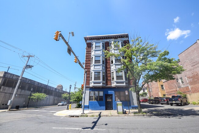
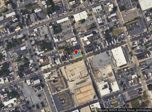
Property Record
202 N 6Th St, Allentown, PA 18102


NEARBY LISTINGS FOR SALE OR LEASE
Property Detail
202 N 6Th St
Allentown-Bethlehem-Easton, PA-NJ
Unk
640711069620-1
LOTS: 012
Officebuilding
Lehigh
X
Pennsylvania
42077C0251F
12
2025
0.16 AC
2025
Lehigh Valley
001000
Philadelphia
11,178 SF
DEMOGRAPHICS near 202 N 6Th St
1 Mile
3 Mile
5 Mile
2024 Total Population
50,368
149,705
252,435
2029 Population
50,849
150,837
254,404
Pop Growth 2024-2029
+ 0.95%
+ 0.76%
+ 0.78%
Average Age
34
37
39
2024 Total Households
17,573
55,246
96,067
HH Growth 2024-2029
+ 1.30%
+ 0.84%
+ 0.84%
Median Household Inc
$37,473
$49,799
$57,080
Avg Household Size
2.70
2.60
2.50
2024 Avg HH Vehicles
1.00
2.00
2.00
Median Home Value
$102,584
$175,253
$205,180
Median Year Built
1947
1955
1958
Nearby Places
Map Layers
Map Styles
 Street
 Aerial
- Restaurants
- Banks
- Shops
- Fitness
- Groceries
PUBLIC TRANSPORTATION
AIRPORT
Lehigh Valley International
DRIVE
WALK
Distance
Lehigh Valley International
9 min
4.3 mi
SALE & LEASE HISTORY
LISTING DATE
SALE/LEASE

Mar 28, 2024
For Lease
Jul 06, 2022
For Lease
Nearby Properties
Address
Land Use
TOTAL SIZE
Lot Size
Zoning
Address
Land Use
TOTAL SIZE
Lot Size
Zoning
302,304 SF
5.15 AC
B-2
Address
Land Use
TOTAL SIZE
Lot Size
Zoning
353,441 SF
4.34 AC
I-G
Address
Land Use
TOTAL SIZE
Lot Size
Zoning
187,337 SF
2.11 AC
I-G
Address
Land Use
TOTAL SIZE
Lot Size
Zoning
298,543 SF
55.08 AC
PIO
Address
Land Use
TOTAL SIZE
Lot Size
Zoning
505,128 SF
25.92 AC
C-2
Address
Land Use
TOTAL SIZE
Lot Size
Zoning
356,283 SF
2 AC
I-G
Address
Land Use
TOTAL SIZE
Lot Size
Zoning
300,783 SF
0.64 AC
B-2
Address
Land Use
TOTAL SIZE
Lot Size
Zoning
295,502 SF
0.77 AC
B-2
Address
Land Use
TOTAL SIZE
Lot Size
Zoning
229,379 SF
1.16 AC
I-G
Address
Land Use
TOTAL SIZE
Lot Size
Zoning
520,201 SF
77.66 AC
PIO
Address
Land Use
TOTAL SIZE
Lot Size
Zoning
314,421 SF
2.22 AC
I-G
Address
Land Use
TOTAL SIZE
Lot Size
Zoning
25.75 AC
B/LI
Address
Land Use
TOTAL SIZE
Lot Size
Zoning
113,608 SF
6.43 AC
I-G
Address
Land Use
TOTAL SIZE
Lot Size
Zoning
124,954 SF
1.23 AC
B-2
Address
Land Use
TOTAL SIZE
Lot Size
Zoning
155,344 SF
B-2
Address
Land Use
TOTAL SIZE
Lot Size
Zoning
252,920 SF
12.88 AC
I-G
Address
Land Use
TOTAL SIZE
Lot Size
Zoning
72,678 SF
17.21 AC
PC
Address
Land Use
TOTAL SIZE
Lot Size
Zoning
266,354 SF
2.56 AC
R-H
Address
Land Use
TOTAL SIZE
Lot Size
Zoning
165,557 SF
0.48 AC
B-2
Address
Land Use
TOTAL SIZE
Lot Size
Zoning
139,462 SF
1.30 AC
B-2
Address
Land Use
TOTAL SIZE
Lot Size
Zoning
113,162 SF
3.02 AC
B/LI
Address
Land Use
TOTAL SIZE
Lot Size
Zoning
85,440 SF
2.10 AC
I-G
Address
Land Use
TOTAL SIZE
Lot Size
Zoning
123,432 SF
30.70 AC
C-2
Address
Land Use
TOTAL SIZE
Lot Size
Zoning
139,812 SF
0.14 AC
B-2
Address
Land Use
TOTAL SIZE
Lot Size
Zoning
208,086 SF
3.13 AC
R-H
Address
Land Use
TOTAL SIZE
Lot Size
Zoning
42,250 SF
3.33 AC
I-G
Address
Land Use
TOTAL SIZE
Lot Size
Zoning
48,816 SF
197.98 AC
I-2
Address
Land Use
TOTAL SIZE
Lot Size
Zoning
326,320 SF
11.73 AC
PC
Address
Land Use
TOTAL SIZE
Lot Size
Zoning
71,838 SF
0.48 AC
I-G
Address
Land Use
TOTAL SIZE
Lot Size
Zoning
133,912 SF
0.79 AC
I-3
The World's #1 Commercial Real Estate Marketplace
Connect with us
© 2025 CoStar Group
The information above has been obtained from sources believed reliable. While we do not doubt its accuracy we have not verified it and make no guarantee, warranty or representation about it. It is your responsibility to independently confirm its accuracy and completeness. Any projections, opinions, assumptions, or estimates used are for example only and do not represent the current or future performance of the property. The value of this transaction to you depends on tax and other factors which should be evaluated by your tax, financial, and legal advisors. You and your advisors should conduct a careful, independent investigation of the property to determine to your satisfaction the suitability of the property for your needs.