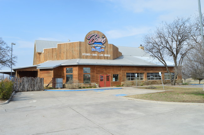
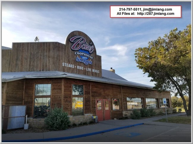
Property Record
2025 N Highway 287, Decatur, TX 76234

Property Detail
2025 N Highway 287
Dallas-Fort Worth-Arlington, TX
LOT 1 BLK A RESTAURANT ADDITION
R25610A0100
Wise
Commercialnec
Texas
B and X Area of moderate flood hazard, usually the area between the limits of the 100-year and 500-year floods.
1
2024
2 AC
2025
Northwest Fort Worth
150202
Dallas/Ft Worth
10,286 SF
NEARBY LISTINGS FOR SALE OR LEASE
DEMOGRAPHICS near 2025 N Highway 287
1 mile
3 mile
5 mile
2025 Total Population
96
7,756
12,984
2030 Population
112
8,946
14,955
Pop Growth 2025-2030
+ 16.67%
+ 15.34%
+ 15.18%
Average Age
40
39
40
2025 Total Households
36
2,864
4,786
HH Growth 2025-2030
+ 16.67%
+ 15.15%
+ 14.96%
Median Household Inc
$66,964
$72,151
$83,762
Avg Household Size
2.70
2.60
2.60
2025 Avg HH Vehicles
2.00
2.00
2.00
Median Home Value
$238,889
$292,679
$328,961
Median Year Built
1994
1990
1993
Nearby Places
Map Layers
Map Styles
 Street
 Aerial
Layers
 Traffic
 Biking
Places
Listings with unknown addresses are not visible on the map
- Restaurants
- Banks
- Shops
- Fitness
- Groceries
SALE & LEASE HISTORY
LISTING DATE
SALE/LEASE

Sep 05, 2017
For Sale
Sep 01, 2017
For Sale
Nov 29, 2017
For Sale
Aug 31, 2017
For Sale
Aug 30, 2017
For Sale
Aug 25, 2017
For Sale
Aug 11, 2017
For Sale
Aug 11, 2017
For Sale
Aug 04, 2017
For Sale
Apr 04, 2018
For Sale
Nearby Properties
Address
Land Use
TOTAL SIZE
Lot Size
Zoning
Address
Land Use
TOTAL SIZE
Lot Size
Zoning
112,981 SF
19.22 AC
Address
Land Use
TOTAL SIZE
Lot Size
Zoning
95,496 SF
15.09 AC
Address
Land Use
TOTAL SIZE
Lot Size
Zoning
95,300 SF
20 AC
Address
Land Use
TOTAL SIZE
Lot Size
Zoning
110,744 SF
7.72 AC
Address
Land Use
TOTAL SIZE
Lot Size
Zoning
49,724 SF
24.49 AC
Address
Land Use
TOTAL SIZE
Lot Size
Zoning
85,477 SF
8.31 AC
Address
Land Use
TOTAL SIZE
Lot Size
Zoning
186,937 SF
25.61 AC
Address
Land Use
TOTAL SIZE
Lot Size
Zoning
50,004 SF
2.03 AC
Address
Land Use
TOTAL SIZE
Lot Size
Zoning
112,598 SF
13.04 AC
Address
Land Use
TOTAL SIZE
Lot Size
Zoning
44,884 SF
9.05 AC
Address
Land Use
TOTAL SIZE
Lot Size
Zoning
57,738 SF
0.52 AC
Address
Land Use
TOTAL SIZE
Lot Size
Zoning
70,408 SF
6.70 AC
Address
Land Use
TOTAL SIZE
Lot Size
Zoning
6,883 SF
5.36 AC
Address
Land Use
TOTAL SIZE
Lot Size
Zoning
17,368 SF
13.80 AC
Address
Land Use
TOTAL SIZE
Lot Size
Zoning
31,050 SF
3.55 AC
Address
Land Use
TOTAL SIZE
Lot Size
Zoning
26,024 SF
7.06 AC
Address
Land Use
TOTAL SIZE
Lot Size
Zoning
48,949 SF
3.74 AC
Address
Land Use
TOTAL SIZE
Lot Size
Zoning
25,821 SF
2.52 AC
Address
Land Use
TOTAL SIZE
Lot Size
Zoning
54,598 SF
7.94 AC
Address
Land Use
TOTAL SIZE
Lot Size
Zoning
25,390 SF
3.03 AC
Address
Land Use
TOTAL SIZE
Lot Size
Zoning
29,012 SF
1.42 AC
Address
Land Use
TOTAL SIZE
Lot Size
Zoning
39,734 SF
3.60 AC
Address
Land Use
TOTAL SIZE
Lot Size
Zoning
73,125 SF
4.32 AC
Address
Land Use
TOTAL SIZE
Lot Size
Zoning
17,308 SF
28.40 AC
Address
Land Use
TOTAL SIZE
Lot Size
Zoning
52,296 SF
5.71 AC
Address
Land Use
TOTAL SIZE
Lot Size
Zoning
9,947 SF
1.67 AC
Address
Land Use
TOTAL SIZE
Lot Size
Zoning
13,178 SF
1.80 AC
Address
Land Use
TOTAL SIZE
Lot Size
Zoning
18,304 SF
3.98 AC
Address
Land Use
TOTAL SIZE
Lot Size
Zoning
18,131 SF
7.25 AC
Address
Land Use
TOTAL SIZE
Lot Size
Zoning
18,593 SF
1.97 AC
The World's #1 Commercial Real Estate Marketplace
Connect with us
© 2026 CoStar Group
The information above has been obtained from sources believed reliable. While we do not doubt its accuracy we have not verified it and make no guarantee, warranty or representation about it. It is your responsibility to independently confirm its accuracy and completeness. Any projections, opinions, assumptions, or estimates used are for example only and do not represent the current or future performance of the property. The value of this transaction to you depends on tax and other factors which should be evaluated by your tax, financial, and legal advisors. You and your advisors should conduct a careful, independent investigation of the property to determine to your satisfaction the suitability of the property for your needs.