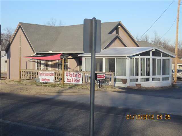
Property Record
2033 N Kickapoo Ave, Shawnee, OK 74804

Property Detail
2033 N Kickapoo Ave
Shawnee, OK
ROSE GARDEN BLK 42 LOTS 13 THRU 16
234000042013000000
Pottawatomie
Restaurantbuilding
Oklahoma
B and X Area of moderate flood hazard, usually the area between the limits of the 100-year and 500-year floods.
13
2024
4 AC
2025
Oklahoma East Area
500600
Other Market Areas
1,605 SF
NEARBY LISTINGS FOR SALE OR LEASE
DEMOGRAPHICS near 2033 N Kickapoo Ave
1 mile
3 mile
5 mile
2025 Total Population
6,045
32,222
36,971
2030 Population
6,181
32,968
37,819
Pop Growth 2025-2030
+ 2.25%
+ 2.32%
+ 2.29%
Average Age
38
38
39
2025 Total Households
2,366
12,265
14,058
HH Growth 2025-2030
+ 2.28%
+ 2.41%
+ 2.38%
Median Household Inc
$54,218
$51,746
$52,613
Avg Household Size
2.30
2.40
2.40
2025 Avg HH Vehicles
2.00
2.00
2.00
Median Home Value
$151,741
$156,771
$166,890
Median Year Built
1961
1972
1973
Nearby Places
Map Layers
Map Styles
 Street
 Aerial
Layers
 Traffic
 Biking
Places
Listings with unknown addresses are not visible on the map
- Restaurants
- Banks
- Shops
- Fitness
- Groceries
PUBLIC TRANSPORTATION
AIRPORT
Will Rogers World
Drive
Walk
Distance
Will Rogers World
47 min
42.6 mi
SALE & LEASE HISTORY
LISTING DATE
SALE/LEASE

May 10, 2018
For Lease
May 02, 2018
For Sale
Mar 30, 2022
For Sale
Mar 11, 2021
For Sale
Jan 23, 2018
For Sale
Nearby Properties
Address
Land Use
TOTAL SIZE
Lot Size
Zoning
Address
Land Use
TOTAL SIZE
Lot Size
Zoning
19,004 SF
5 AC
Address
Land Use
TOTAL SIZE
Lot Size
Zoning
14,455 SF
1 AC
Address
Land Use
TOTAL SIZE
Lot Size
Zoning
15,888 SF
2.03 AC
Address
Land Use
TOTAL SIZE
Lot Size
Zoning
14,735 SF
3.92 AC
Address
Land Use
TOTAL SIZE
Lot Size
Zoning
17,380 SF
2.50 AC
Address
Land Use
TOTAL SIZE
Lot Size
Zoning
20,522 SF
0.80 AC
Address
Land Use
TOTAL SIZE
Lot Size
Zoning
12,330 SF
3 AC
Address
Land Use
TOTAL SIZE
Lot Size
Zoning
39,428 SF
18 AC
Address
Land Use
TOTAL SIZE
Lot Size
Zoning
19,720 SF
5 AC
Address
Land Use
TOTAL SIZE
Lot Size
Zoning
66,012 SF
0.40 AC
Address
Land Use
TOTAL SIZE
Lot Size
Zoning
12,120 SF
3.50 AC
Address
Land Use
TOTAL SIZE
Lot Size
Zoning
30,094 SF
8 AC
Address
Land Use
TOTAL SIZE
Lot Size
Zoning
13,000 SF
3 AC
Address
Land Use
TOTAL SIZE
Lot Size
Zoning
6,595 SF
11.84 AC
Address
Land Use
TOTAL SIZE
Lot Size
Zoning
21,418 SF
16 AC
Address
Land Use
TOTAL SIZE
Lot Size
Zoning
Address
Land Use
TOTAL SIZE
Lot Size
Zoning
146,320 SF
14.37 AC
Address
Land Use
TOTAL SIZE
Lot Size
Zoning
8,026 SF
0.28 AC
Address
Land Use
TOTAL SIZE
Lot Size
Zoning
53,709 SF
8.31 AC
Address
Land Use
TOTAL SIZE
Lot Size
Zoning
54,996 SF
12.15 AC
Address
Land Use
TOTAL SIZE
Lot Size
Zoning
5,347 SF
0.23 AC
Address
Land Use
TOTAL SIZE
Lot Size
Zoning
11,274 SF
4 AC
Address
Land Use
TOTAL SIZE
Lot Size
Zoning
18,368 SF
3.68 AC
Address
Land Use
TOTAL SIZE
Lot Size
Zoning
5,852 SF
1 AC
Address
Land Use
TOTAL SIZE
Lot Size
Zoning
10,525 SF
5.50 AC
Address
Land Use
TOTAL SIZE
Lot Size
Zoning
19,804 SF
1.75 AC
Address
Land Use
TOTAL SIZE
Lot Size
Zoning
7,500 SF
3 AC
Address
Land Use
TOTAL SIZE
Lot Size
Zoning
9,000 SF
0.48 AC
The World's #1 Commercial Real Estate Marketplace
Connect with us
© 2026 CoStar Group
The information above has been obtained from sources believed reliable. While we do not doubt its accuracy we have not verified it and make no guarantee, warranty or representation about it. It is your responsibility to independently confirm its accuracy and completeness. Any projections, opinions, assumptions, or estimates used are for example only and do not represent the current or future performance of the property. The value of this transaction to you depends on tax and other factors which should be evaluated by your tax, financial, and legal advisors. You and your advisors should conduct a careful, independent investigation of the property to determine to your satisfaction the suitability of the property for your needs.