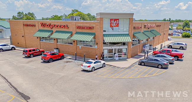
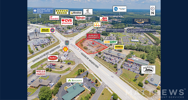
Property Record
2041 E Main St, Dothan, AL 36301

Property Detail
2041 E Main St
10-04-20-3-001-004-000
BEG @ NE INT OF ROSS CLARK CIR & E MAIN ST IN E1/2 OF SW1/4OF SEC 20 T3N R27E TH N ALG R/W 225.4' E 59.5' S 1.54' SE 88.89' E
Storebuilding
Houston
B and X Area of moderate flood hazard, usually the area between the limits of the 100-year and 500-year floods.
Alabama
2025
1.85 AC
2025
Dothan/Enterprise
041400
Other Market Areas
13,638 SF
Dothan, AL
NEARBY LISTINGS FOR SALE OR LEASE
DEMOGRAPHICS near 2041 E Main St
1 mile
3 mile
5 mile
2025 Total Population
3,262
27,008
54,039
2030 Population
3,302
27,526
55,009
Pop Growth 2025-2030
+ 1.23%
+ 1.92%
+ 1.79%
Average Age
39
39
40
2025 Total Households
1,287
11,206
22,706
HH Growth 2025-2030
+ 1.32%
+ 2.00%
+ 1.85%
Median Household Inc
$35,793
$36,910
$45,937
Avg Household Size
2.40
2.30
2.30
2025 Avg HH Vehicles
2.00
2.00
2.00
Median Home Value
$107,216
$130,538
$166,392
Median Year Built
1975
1972
1976
Nearby Places
Map Layers
Map Styles
 Street
 Aerial
Layers
 Traffic
 Biking
Places
Listings with unknown addresses are not visible on the map
- Restaurants
- Banks
- Shops
- Fitness
- Groceries
PUBLIC TRANSPORTATION
AIRPORT
Dothan Regional
Drive
Walk
Distance
Dothan Regional
20 min
11.2 mi
SALE & LEASE HISTORY
LISTING DATE
SALE/LEASE

Jul 18, 2025
For Sale
Dec 06, 2017
For Sale
Nearby Properties
Address
Land Use
TOTAL SIZE
Lot Size
Zoning
Address
Land Use
TOTAL SIZE
Lot Size
Zoning
9,150 SF
Address
Land Use
TOTAL SIZE
Lot Size
Zoning
27,224 SF
9.25 AC
Address
Land Use
TOTAL SIZE
Lot Size
Zoning
3,700 SF
19.20 AC
Address
Land Use
TOTAL SIZE
Lot Size
Zoning
1,800 SF
21.49 AC
Address
Land Use
TOTAL SIZE
Lot Size
Zoning
68,981 SF
1.97 AC
Address
Land Use
TOTAL SIZE
Lot Size
Zoning
88,725 SF
17 AC
Address
Land Use
TOTAL SIZE
Lot Size
Zoning
34,399 SF
17.70 AC
Address
Land Use
TOTAL SIZE
Lot Size
Zoning
11,422 SF
38 AC
Address
Land Use
TOTAL SIZE
Lot Size
Zoning
46,876 SF
12.66 AC
Address
Land Use
TOTAL SIZE
Lot Size
Zoning
2,680 SF
1.67 AC
Address
Land Use
TOTAL SIZE
Lot Size
Zoning
71,457 SF
3.90 AC
Address
Land Use
TOTAL SIZE
Lot Size
Zoning
39,223 SF
12.03 AC
Address
Land Use
TOTAL SIZE
Lot Size
Zoning
90,918 SF
0.88 AC
Address
Land Use
TOTAL SIZE
Lot Size
Zoning
10,308 SF
11.24 AC
Address
Land Use
TOTAL SIZE
Lot Size
Zoning
170,846 SF
3.49 AC
Address
Land Use
TOTAL SIZE
Lot Size
Zoning
42,982 SF
1.24 AC
Address
Land Use
TOTAL SIZE
Lot Size
Zoning
2,737 SF
16 AC
Address
Land Use
TOTAL SIZE
Lot Size
Zoning
1,776 SF
2.89 AC
Address
Land Use
TOTAL SIZE
Lot Size
Zoning
30,565 SF
3.84 AC
Address
Land Use
TOTAL SIZE
Lot Size
Zoning
19,189 SF
5.26 AC
Address
Land Use
TOTAL SIZE
Lot Size
Zoning
48,628 SF
5.13 AC
Address
Land Use
TOTAL SIZE
Lot Size
Zoning
6,930 SF
5.88 AC
Address
Land Use
TOTAL SIZE
Lot Size
Zoning
36,505 SF
3.65 AC
Address
Land Use
TOTAL SIZE
Lot Size
Zoning
34,743 SF
6.54 AC
Address
Land Use
TOTAL SIZE
Lot Size
Zoning
83,169 SF
5.20 AC
Address
Land Use
TOTAL SIZE
Lot Size
Zoning
24,478 SF
Address
Land Use
TOTAL SIZE
Lot Size
Zoning
1,603 SF
4.10 AC
Address
Land Use
TOTAL SIZE
Lot Size
Zoning
48,556 SF
7.48 AC
Address
Land Use
TOTAL SIZE
Lot Size
Zoning
4,338 SF
10.80 AC
Address
Land Use
TOTAL SIZE
Lot Size
Zoning
150,056 SF
9.43 AC
The World's #1 Commercial Real Estate Marketplace
Connect with us
© 2026 CoStar Group
The information above has been obtained from sources believed reliable. While we do not doubt its accuracy we have not verified it and make no guarantee, warranty or representation about it. It is your responsibility to independently confirm its accuracy and completeness. Any projections, opinions, assumptions, or estimates used are for example only and do not represent the current or future performance of the property. The value of this transaction to you depends on tax and other factors which should be evaluated by your tax, financial, and legal advisors. You and your advisors should conduct a careful, independent investigation of the property to determine to your satisfaction the suitability of the property for your needs.