Property Record
2055 W Amherst Ave, Englewood, CO 80110
Current Lease Availabilities
NEARBY LISTINGS FOR SALE OR LEASE
Property Detail
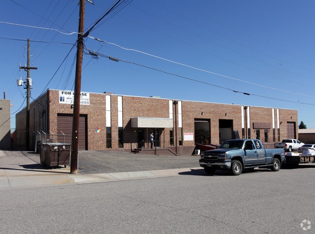
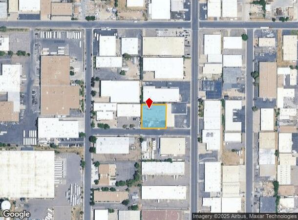
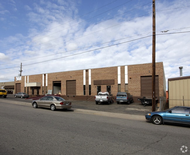
2055 W Amherst Ave
Denver-Aurora-Lakewood, CO
Yale-Tejon Industrial Park
1971-33-2-04-013
SUBDIVISIONCD 068550 SUBDIVISIONNAME YALE-TEJON INDUSTRIAL PARK BLOCK 002 LOT 005 WLY 150 FT OF LOT 5 BLK 2 YALE TEJON INDUSTRIAL PARK
Warehouse
Arapahoe
X
Colorado
0800460192J
005
2023
0.50 AC
2024
Lower South Central
005551
Denver
14,548 SF
DEMOGRAPHICS near 2055 W Amherst Ave
1 Mile
3 Mile
5 Mile
2024 Total Population
12,130
146,549
388,724
2029 Population
12,164
146,860
390,454
Pop Growth 2024-2029
+ 0.28%
+ 0.21%
+ 0.45%
Average Age
36
38
39
2024 Total Households
4,472
58,194
169,790
HH Growth 2024-2029
+ 0.18%
+ 0.19%
+ 0.53%
Median Household Inc
$66,536
$74,431
$78,371
Avg Household Size
2.50
2.40
2.20
2024 Avg HH Vehicles
2.00
2.00
2.00
Median Home Value
$350,889
$473,691
$535,244
Median Year Built
1976
1960
1968
Nearby Places
- Restaurants
- Banks
- Shops
- Fitness
- Groceries
PUBLIC TRANSPORTATION
COMMUTER RAIL
Union Station: Lodo-Coors Field-16Th Street Mall (C Line - Denver Regional Transportation District Light Rail (TheRide), E Line - Denver Regional Transportation District Light Rail (TheRide), W Line - Denver Regional Transportation District Light Rail (TheRide))
DRIVE
WALK
Distance
Union Station: Lodo-Coors Field-16Th Street Mall (C Line - Denver Regional Transportation District Light Rail (TheRide), E Line - Denver Regional Transportation District Light Rail (TheRide), W Line - Denver Regional Transportation District Light Rail (TheRide))
15 min
8.3 mi
Denver (California Zephyr - Amtrak)
DRIVE
WALK
Distance
Denver (California Zephyr - Amtrak)
15 min
8.5 mi
AIRPORT
Denver International
DRIVE
WALK
Distance
Denver International
44 min
32.6 mi
Freight Ports
Tulsa Port Of Catoosa
DRIVE
WALK
Distance
Tulsa Port Of Catoosa
742 min
718.1 mi
Nearby Properties
Address
Land Use
TOTAL SIZE
Lot Size
Zoning
Address
Land Use
TOTAL SIZE
Lot Size
Zoning
1,137,044 SF
35.49 AC
CMP-EI
Address
Land Use
TOTAL SIZE
Lot Size
Zoning
441,643 SF
9.79 AC
H-1-B
Address
Land Use
TOTAL SIZE
Lot Size
Zoning
550,760 SF
13.25 AC
CMP-EI
Address
Land Use
TOTAL SIZE
Lot Size
Zoning
543,122 SF
13.43 AC
CMP-EI
Address
Land Use
TOTAL SIZE
Lot Size
Zoning
248,291 SF
128.77 AC
CMP-H2
Address
Land Use
TOTAL SIZE
Lot Size
Zoning
330,776 SF
48.11 AC
CMP-H2
Address
Land Use
TOTAL SIZE
Lot Size
Zoning
362,988 SF
4.71 AC
T-MU-30
Address
Land Use
TOTAL SIZE
Lot Size
Zoning
214,192 SF
0.03 AC
Address
Land Use
TOTAL SIZE
Lot Size
Zoning
124,658 SF
2.13 AC
CMP-EI
Address
Land Use
TOTAL SIZE
Lot Size
Zoning
356,004 SF
4.59 AC
C-MX-12
Address
Land Use
TOTAL SIZE
Lot Size
Zoning
341,493 SF
4.22 AC
T-MU-30
Address
Land Use
TOTAL SIZE
Lot Size
Zoning
533,298 SF
3.23 AC
C-MX
Address
Land Use
TOTAL SIZE
Lot Size
Zoning
158,805 SF
3.71 AC
CMP-EI
Address
Land Use
TOTAL SIZE
Lot Size
Zoning
304,560 SF
23.94 AC
S-SU-F
Address
Land Use
TOTAL SIZE
Lot Size
Zoning
381 SF
66.05 AC
I-B
Address
Land Use
TOTAL SIZE
Lot Size
Zoning
377,735 SF
1.72 AC
G-RX
Address
Land Use
TOTAL SIZE
Lot Size
Zoning
208,529 SF
34.81 AC
R-5
Address
Land Use
TOTAL SIZE
Lot Size
Zoning
368,527 SF
18.71 AC
S-SU-D
Address
Land Use
TOTAL SIZE
Lot Size
Zoning
33,500 SF
53.33 AC
Address
Land Use
TOTAL SIZE
Lot Size
Zoning
472,235 SF
1.98 AC
C-RX
Address
Land Use
TOTAL SIZE
Lot Size
Zoning
117,641 SF
7.44 AC
S-SU-D
Address
Land Use
TOTAL SIZE
Lot Size
Zoning
458,000 SF
5.85 AC
Address
Land Use
TOTAL SIZE
Lot Size
Zoning
139,858 SF
2.36 AC
Address
Land Use
TOTAL SIZE
Lot Size
Zoning
239,840 SF
3.11 AC
T-MU-30
Address
Land Use
TOTAL SIZE
Lot Size
Zoning
236,250 SF
2.22 AC
C-MX-5
Address
Land Use
TOTAL SIZE
Lot Size
Zoning
422,426 SF
1.05 AC
C-RX
Address
Land Use
TOTAL SIZE
Lot Size
Zoning
221,025 SF
8.45 AC
PUD
Address
Land Use
TOTAL SIZE
Lot Size
Zoning
6.84 AC
C-MX-12
Address
Land Use
TOTAL SIZE
Lot Size
Zoning
118,881 SF
107.83 AC
Address
Land Use
TOTAL SIZE
Lot Size
Zoning
107,159 SF
26.40 AC
The World's #1 Commercial Real Estate Marketplace
Connect with us
© 2025 CoStar Group
The information above has been obtained from sources believed reliable. While we do not doubt its accuracy we have not verified it and make no guarantee, warranty or representation about it. It is your responsibility to independently confirm its accuracy and completeness. Any projections, opinions, assumptions, or estimates used are for example only and do not represent the current or future performance of the property. The value of this transaction to you depends on tax and other factors which should be evaluated by your tax, financial, and legal advisors. You and your advisors should conduct a careful, independent investigation of the property to determine to your satisfaction the suitability of the property for your needs.