Property Record
206 Merrow Rd, Tolland, CT 06084
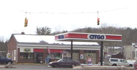

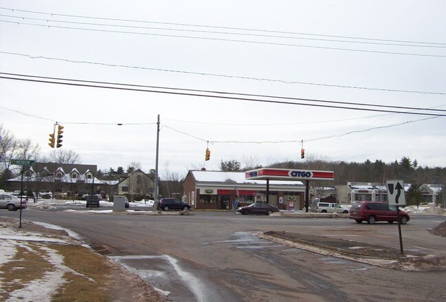
Property Detail
206 Merrow Rd
TOLL-000028-C000000-000006
Capitol
Commercialbuilding
Connecticut
GDD
6-0
2025
0.74 AC
2025
Tolland County
533102
Hartford
2,088 SF
Hartford-West Hartford-East Hartford, CT
NEARBY LISTINGS FOR SALE OR LEASE
DEMOGRAPHICS near 206 Merrow Rd
1 mile
3 mile
5 mile
2025 Total Population
902
11,075
34,087
2030 Population
913
11,271
34,880
Pop Growth 2025-2030
+ 1.22%
+ 1.77%
+ 2.33%
Average Age
43
42
41
2025 Total Households
339
4,155
13,651
HH Growth 2025-2030
+ 1.18%
+ 1.76%
+ 2.43%
Median Household Inc
$112,500
$121,219
$99,488
Avg Household Size
2.60
2.60
2.40
2025 Avg HH Vehicles
2.00
2.00
2.00
Median Home Value
$338,815
$355,083
$344,241
Median Year Built
1977
1979
1977
Nearby Places
Map Layers
Map Styles
 Street
 Aerial
Layers
 Traffic
 Biking
Places
Listings with unknown addresses are not visible on the map
- Restaurants
- Banks
- Shops
- Fitness
- Groceries
PUBLIC TRANSPORTATION
AIRPORT
Bradley International
Drive
Walk
Distance
Bradley International
49 min
27.9 mi
SALE & LEASE HISTORY
LISTING DATE
SALE/LEASE

Jan 19, 2017
For Lease
Nearby Properties
Address
Land Use
TOTAL SIZE
Lot Size
Zoning
Address
Land Use
TOTAL SIZE
Lot Size
Zoning
258,330 SF
68.50 AC
RDD
Address
Land Use
TOTAL SIZE
Lot Size
Zoning
168,410 SF
100.15 AC
RDD
Address
Land Use
TOTAL SIZE
Lot Size
Zoning
46.42 AC
VCZ
Address
Land Use
TOTAL SIZE
Lot Size
Zoning
20.50 AC
GDD
Address
Land Use
TOTAL SIZE
Lot Size
Zoning
48 AC
RDD
Address
Land Use
TOTAL SIZE
Lot Size
Zoning
63,016 SF
8.60 AC
R80
Address
Land Use
TOTAL SIZE
Lot Size
Zoning
59.01 AC
RDD
Address
Land Use
TOTAL SIZE
Lot Size
Zoning
10 AC
RDD
Address
Land Use
TOTAL SIZE
Lot Size
Zoning
50.71 AC
GDD
Address
Land Use
TOTAL SIZE
Lot Size
Zoning
26,602 SF
5.47 AC
VCZ
Address
Land Use
TOTAL SIZE
Lot Size
Zoning
27,740 SF
11.92 AC
RDD
Address
Land Use
TOTAL SIZE
Lot Size
Zoning
9.05 AC
TCZ
Address
Land Use
TOTAL SIZE
Lot Size
Zoning
16,414 SF
3.44 AC
GDD
Address
Land Use
TOTAL SIZE
Lot Size
Zoning
10,728 SF
39.68 AC
RDD
Address
Land Use
TOTAL SIZE
Lot Size
Zoning
37,556 SF
7.91 AC
GDD
Address
Land Use
TOTAL SIZE
Lot Size
Zoning
1,200 SF
108 AC
RDD
Address
Land Use
TOTAL SIZE
Lot Size
Zoning
1.99 AC
VCZ
Address
Land Use
TOTAL SIZE
Lot Size
Zoning
1,132 SF
0.78 AC
RDD
Address
Land Use
TOTAL SIZE
Lot Size
Zoning
32,583 SF
16.71 AC
DC
Address
Land Use
TOTAL SIZE
Lot Size
Zoning
44,000 SF
5 AC
DI
Address
Land Use
TOTAL SIZE
Lot Size
Zoning
15.32 AC
TCZ
Address
Land Use
TOTAL SIZE
Lot Size
Zoning
16,128 SF
4.91 AC
TCZ
Address
Land Use
TOTAL SIZE
Lot Size
Zoning
6,806 SF
131.13 AC
RDD
Address
Land Use
TOTAL SIZE
Lot Size
Zoning
3.42 AC
VCZ
Address
Land Use
TOTAL SIZE
Lot Size
Zoning
9,259 SF
2.24 AC
NCZG
Address
Land Use
TOTAL SIZE
Lot Size
Zoning
96.50 AC
GR80
Address
Land Use
TOTAL SIZE
Lot Size
Zoning
10,848 SF
8 AC
DCR
Address
Land Use
TOTAL SIZE
Lot Size
Zoning
31,200 SF
5.10 AC
DI
Address
Land Use
TOTAL SIZE
Lot Size
Zoning
7,060 SF
11.60 AC
GR80
Address
Land Use
TOTAL SIZE
Lot Size
Zoning
14,845 SF
6 AC
RDD
The World's #1 Commercial Real Estate Marketplace
Connect with us
© 2026 CoStar Group
The information above has been obtained from sources believed reliable. While we do not doubt its accuracy we have not verified it and make no guarantee, warranty or representation about it. It is your responsibility to independently confirm its accuracy and completeness. Any projections, opinions, assumptions, or estimates used are for example only and do not represent the current or future performance of the property. The value of this transaction to you depends on tax and other factors which should be evaluated by your tax, financial, and legal advisors. You and your advisors should conduct a careful, independent investigation of the property to determine to your satisfaction the suitability of the property for your needs.